Arghakhanchi is one of the districts of Lumbini Province in Nepal. The district headquarter is Sandhikharka. The district covers an area of 1,193 km2 (461 sq mi) and has a population (2011) of 197,632. Its neighboring districts are Palpa in the east, Gulmi in the north, Kapilvastu District in the south and Pyuthan in the west. The district also covers 4.18km of daily busy road connecting Kapilvastu and Bhalubang, Lalmatiya, Dang with Rapti River as Mahendra Highway or Easy-West Highway.

Baglung District, a part of Gandaki Province, is one of the seventy-seven districts of Nepal. The district, with Baglung as its district headquarters, covers an area of 1,784 km2 (689 sq mi) and has a population (2011) of 268,613.

Kaski District, a part of Gandaki Province, is one of the seventy-seven districts of Nepal. The name is disambiguated from Kaskikot, the ancient Kaski Kingdom.

Palpa District (Nepali: पाल्पा जिल्ला, a part of Lumbini Province, is one of the seventy-seven districts of Nepal, a landlocked country of South Asia. The district, with Tansen as its headquarters, covers an area of 1,373 km2 and has a population of 261,180.

Pyuthan District (Nepali: प्युठान जिल्ला, is a "hill" district some 427.6 km west of Kathmandu in Lumbini Province in midwestern Nepal. Pyuthan covers an area of 1,309 km2 with population of 212,484 in 2001 and 226,796 in 2011. Pyuthan Khalanga is the district's administrative center.

Salyan District IPA: [sʌljan], in Karnali Province, is one of the seventy-seven districts of Nepal. Salyan covers an area of 1,462 km2 (564 sq mi) with a population of 213,500 in 2001 and 241,716 in 2011. The district's administrative center is named Salyan or Salyan Khalanga, today it is part of Shaarada Municipality.

Baglung is a municipality in Gandaki Province, in western Nepal, 275 km (171 mi) west of Kathmandu. It is the administrative headquarters of Baglung District. Baglung serves as the major center for business, finance, education, service and healthcare for the people of mid-Kali Gandaki valley that encompass Beni, Jaljala, Baglung, Kushma, Kathekhola, Galkot, Phalewas and Jaimuni local bodies. The city is located at the cross-section of Kaligandaki corridor highway and midhill highway that transverse Nepal in north–south and east–west directions respectively.

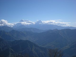
Jomsom, also known as Dzongsam, is the centre of Gharapjhong rural municipality in Mustang district and a former independent village development committee situated at an altitude of about 2,700 metres (8,900 ft) in Gandaki Province of western Nepal. The soaring peaks of Dhaulagiri and Nilgiri form a backdrop to the town straddling the Kali Gandaki River, which flows right through the centre of Jomsom. Along the banks of the Kali Gandaki, black fossilised stones called shaligram, considered as an iconic symbol and reminder of the god Vishnu in the Hindu culture, can be found. Such stones are believed to be found only in the Kali Gandaki, and are considered holy by Hindus.
Burtibang is a village development committee in Baglung District in the Dhaulagiri Zone of central Nepal. Burtibang is the second-largest commercial city in the district after Baglung.
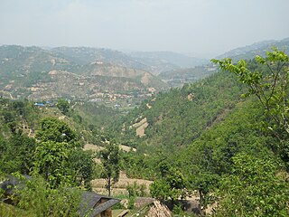
Sukhaura is administered under Bareng Rural Municipality of Baglung District of Gandaki Province. Sukhaura is located in the south-eastern part of Baglung District bordering Gulmi District in the South. Sukhaura is rich in forest resources. A large area of the village is occupied by the thick forest. Some forest areas are preserved under community efforts. Sukhaura is surrounded by Salyan in the east, Galkot in the north and the west and Chandrakot, Gulmi in the south. Sukhaura is also characterised as one of the politically conscious villages of the district. It is mainly inhabited by the Magar and the Kshetri communities. Nepali is the lingua-franca. People are mostly Hindus. Sukhaura is well-connected with transportation, electricity and communication networks. Water supply is now adequately accessible to each house. There is full-equipped educational facility up to +2 level in Sukhaura. Sukhaura's main economy is based on agriculture and animal husbandry. Maize, millet, barley, wheat, buckwheat and potato are main cereals produced in the village. The village is enriched with medicinal herbs. Nowadays people are trying to modernize the agriculture that is expected to establish the market access to the nearby semi-towns. The villagers are also paying attention to professionalize the animal husbandry. Some notable places are Majhgaun, Dhampu, Pancheuli, Vitriban, Bahundada etc. The village is rapidly modernising in recent times. The village is also rich in culture and tradition. There are a few individuals from the village who have reached very influential position of national politics as well as artistic arena.
Dhikurpokhari is a suburb and former Village Development Committee in Kaski District in the Gandaki Province of northern-central Nepal. At the 1991 Nepal census, it had a population of 7,392 persons in 1,427 individual households.
Bhimad is a municipality in Tanahu District in the Gandaki Zone of central Nepal. At the time of the 2011 Nepal census the city had a population of 8,414 people living in 2,191 individual households. It is 30 minutes away from Khairenitar. Due to its historic importance, a plan is underway to incorporate the Shukla Gandaki municipality and form the Bhimad Sub-metropolitan City in the near future. This is being done in order to improve the integrated development of this region because the city is currently experiencing accelerated development. While Bhimad lacks sufficient hospital facilities for its population size, there are many health centers in various communities.

Rampur is a municipality in Palpa District in Lumbini Province of West southern Nepal. According to hindu mythology, Maharishi Vasistha taught Yogavasistha to lord Rama in the cave of Rampur. Rampur is 65 km northeast from the headquarter city Tansen. The valley is bounded by Syangja District in the north, Tanahun District in the northeast, and Nawalparasi District in the east. The popular religious river Kaligandaki disconnects the boundary in the northern part.
Malika Dhuri is a 3,700 m (12,100 ft) high mountain peak in Muna, Myagdi, Nepal. The name is derived from two local words Malika and Dhuri. Its coordinate is at.
Galkot is a municipality in Baglung district of Gandaki province of Nepal. It consists of several VDCs. Nearby cities include Gulmi and Pokhara. Its geographic coordinates are 28°13'24"N 83°25'29"E.
Serachaur सेराचौर is a village which is located in Kaski District, Gandaki Province, Nepal. The word Sera refers to a plain land which is used to farm and supply food to a palace and Chaur means a grassy land. First settlers of this village were Adhikari Family. It is a part of the Annapurna Gaunpalika ward number- 2, Kaski, Nepal. Pastly the village was part of Dhikurpokhari V.D.C but later the Ministry of Federal Affairs and Local Development (Nepal) dissolved the existing village development committees and announced the establishment of this new local body. Visitors can take the Baglung Highway, Kaskikot road and other existing trails to reach here. Concrete pavement is recent installation to the road.

Varagung Muktichhetra, earlier Bahragaun Muktichhetra is a rural municipality situated in Mustang District of Gandaki Province of Nepal The rural municipality is situated on the southern part of the Mustang, surrounded by Dalome rural municipality on the north, Gharpajhong and Thasang rural municipalities on the south, Manang District on the east and Dolpa District on the west. The north-southern border of the rural municipality touches the Myagdi District boundary.
Annapurna Rural Municipality, Kaski is a Gaunpalika in Kaski District in Gandaki Province of Nepal named after the Annapurna Mountain. On 12 March 2017, the Government of Nepal implemented a new local administrative structure. With the implementation of the new local administrative structure, VDSs have been replaced with municipal and village councils. Annapurna Gaupalika is one of these 753 local units.
Bareng Rural Municipality (Bareng Gaupalika) (Nepali: वरेङ गाउँपालिका) is a Gaunpalika in Baglung District in Gandaki Province of Nepal. On 12 March 2017, the government of Nepal implemented a new local administrative structure, in which VDCs have been replaced with municipal and Village Councils. Bareng is one of these 753 local units.
Mahashila Rural Municipality is a Gaunpalika in Parbat District in Gandaki of Nepal. On 12 March 2017, the government of Nepal implemented a new local administrative structure, with the implementation of the new local governance structure, Village Development Committees have been merged to form Municipalities and Gaunpalikas.

