Northern New Mexico in cultural terms usually refers to the area of heavy Spanish settlement in the north-central part of New Mexico, however, New Mexico state government also uses the term to mean the northwest and north central, but to exclude both the northeastern high plains counties and Sandoval County. The top 5 largest cities in Northern New Mexico are: (1) Santa Fe; (2) Las Vegas; (3) Espanola; (4) Los Alamos; (5) Raton.

This is a list of properties and districts in New Mexico that are on the National Register of Historic Places. There are more than 1,100 listings. Of these, 46 are National Historic Landmarks. There are listings in each of the state's 33 counties.
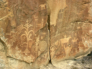
Crow Canyon Archaeological District is a historic site in Rio Arriba and San Juan counties in New Mexico. It is located about 30 miles southeast of the city of Farmington. Located in Dinétah, the traditional homeland of the Navajo people, the site contains a variety of Navajo ruins and rock art from the 16th, 17th, and 18th centuries. There are several large petroglyph panels which include both Navajo and Pueblo images, as well as a handful of Navajo defensive structures known as pueblitos which were built in the 18th century during a period of conflict with the Utes.

The Albuquerque–Santa Fe–Las Vegas combined statistical area is made up of nine counties in north central New Mexico. The combined statistical area consists of the Albuquerque and Santa Fe metropolitan statistical areas, and the Las Vegas, Los Alamos, Española, and Grants micropolitan statistical areas. As of the 2010 census, the CSA had a population of 1,146,049. Roughly 55% of New Mexico's residents live in this area. Prior to the 2013 redefintions, the CSA consisted only of the Santa Fe metropolitan statistical area and the Española micropolitan statistical area. The total land area of the Albuquerque–Santa Fe–Las Vegas combined statistical area is 26,421 sq. mi.

Embudo is an unincorporated community in Rio Arriba County, New Mexico, United States. It is on NM State Road 68. The Embudo Station is located 2.9 miles south of the intersection of NM State Road 75, near where the Embudo River flows into the Rio Grande.

The Rio Grande Trail is a proposed long distance trail along the Rio Grande in the U.S. state of New Mexico. The river extends over 1,800 total miles, some 700 miles (1,100 km) of which pass through the heart of New Mexico. It is the state's primary drainage feature and most valuable natural and cultural resource. The river and its bosque provide a wide variety of recreation, including hunting and fishing, birdwatching, river rafting, hiking, biking, and horseback riding. The river also flows through or beside numerous spectacular and geologically interesting landforms, the result of extensive volcanism and erosion within the Rio Grande Rift. Although some trail advocates would like to see the trail extended the full distance through New Mexico, from the Colorado border to the United States–Mexico border, the portion proposed for initial development extends 300 miles (480 km), from Bernalillo south to Las Cruces.

San Gabriel de Yungue-Ouinge, or San Gabriel de Yunque, was the site of the first Spanish capital of its provincial territory of Santa Fe de Nuevo México. It is located where the Rio Chama meets the Rio Grande, west of present-day Ohkay Owingeh, New Mexico. The pueblo of Yuque Yunque was provided as a gesture of goodwill toward Juan de Oñate, and he founded his colonial government there. It was moved to Santa Fe in 1610. The site was declared a National Historic Landmark in 1964. The archaeological site was leveled and plowed over in 1984, and a historical marker has been placed on the west side of the Rio Grande, off the old New Mexico State Road 74.
San Lorenzo, New Mexico can refer to:
Sublette is a railroad town in northern Rio Arriba County, New Mexico, built as a section station in 1880. It is located north-east of Chama, just south of the Colorado state line and at milepost 306.1 of the former Denver and Rio Grande Western Railroad. When the Denver & Rio Grande Western Railroad abandoned its narrow gauge lines in the late 1960s, two parts of the system were preserved independently: the Cumbres & Toltec Scenic Railroad from Antonito to Chama, including Sublette itself, and the Durango and Silverton Narrow Gauge Railroad. Sublette sits at an elevation of 9,281 feet in the southeastern San Juan Mountains.

Northern Rio Grande National Heritage Area is a federally designated National Heritage Area in the U.S. state of New Mexico. The national heritage area includes a section of the upper Rio Grande Valley that has been inhabited by the Puebloan peoples since the early Pre-Columbian era.

San Antonio Mountain is a free-standing volcanic peak in Rio Arriba County, New Mexico. With an elevation of 10,908 feet, San Antonio Mountain is the highest peak within the Taos Plateau volcanic field, the largest volcanic field within the Rio Grande Rift valley.
Cañoncito or Canoncito may refer to the following places in the U.S. state of New Mexico:
Riverside, New Mexico may refer to:

Riverside is a former village, now a suburb of Española, New Mexico, in Rio Arriba County, New Mexico, in the southwestern United States. It is located in north-central New Mexico, on the left bank of the Rio Grande across the river from Española proper. It is on NM Route 68 just north of US Route 285 and just south of the former village of Santa Niño. To the southeast is the former village of San Pedro.
San Jose is a census-designated place in Rio Arriba County, New Mexico, United States. Its population was 695 as of the 2010 census. U.S. Route 84 and U.S. Route 285 pass through the community.
San Jose may refer to the following places in the U.S. state of New Mexico:
Chamita is an unincorporated community and census-designated place in Rio Arriba County, New Mexico, United States. Its population was 870 as of the 2010 census. New Mexico State Road 74 passes through the community. During its earlier years, the community was known as San Pedro De Chamita and served as the first County Seat for Rio Arriba county.


