
Santa Cruz is the largest city and the county seat of Santa Cruz County, in Northern California. As of the 2020 census, the city population was 62,956. Situated on the northern edge of Monterey Bay, Santa Cruz is a popular tourist destination, owing to its beaches, surf culture, and historic landmarks.

Boulder Creek is a small rural mountain community in the coastal Santa Cruz Mountains. It is a census-designated place (CDP) in Santa Cruz County, California, with a population of 5,429 as of the 2020 census. Throughout its history, Boulder Creek has been home to a logging town and a resort community, as well as a counter-culture haven. Today, it is identified as the gateway to Big Basin Redwoods State Park.
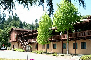
Scotts Valley is a small city in Santa Cruz County, California, United States, about thirty miles (48 km) south of downtown San Jose and six miles (9.7 km) north of the city of Santa Cruz, in the upland slope of the Santa Cruz Mountains. As of the 2020 census, the city population was 12,224. Principal access to the city is supplied by State Route 17 that connects San Jose and Santa Cruz. The city was incorporated in 1966.

The Santa Cruz Mountains are a mountain range in central and Northern California, United States, constituting a part of the Pacific Coast Ranges. They form a ridge down the San Francisco Peninsula, south of San Francisco. They separate the Pacific Ocean from the San Francisco Bay and the Santa Clara Valley, and continue south to the Central Coast, bordering Monterey Bay and ending at the Salinas Valley. The range passes through the counties of San Mateo, Santa Clara, and Santa Cruz, with the Pajaro River forming the southern boundary.

Silicon Valley Monterey Bay Council (#055) is a Boy Scouts of America council headquartered in San Jose, California. It was the result of a council merger between the Santa Clara County Council and the Monterey Bay Area Council. In 2004, the previous two councils served over 11,000 youth in over 400 Boy Scout troops, Cub Scout packs, Venturing crews, and Explorer posts. In 2012, the Monterey Bay Area Council announced that after 89 years as a separate council, it had agreed to merge back into the Santa Clara County Council. As of 2013, the council served 13,000 youth in four different counties.
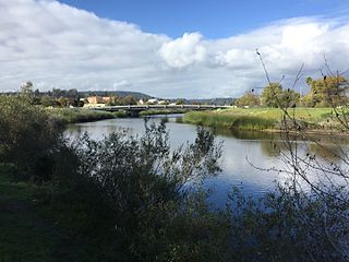
The San Lorenzo River is a 29.3-mile-long (47.2 km) river in the U.S. state of California. The name San Lorenzo derives from the Spanish language for "Saint Lawrence" due to its reported sighting on that saint's feast day by Spanish explorers. Its headwaters originate in Castle Rock State Park in the Santa Cruz Mountains and flow south by southeast through the San Lorenzo Valley before passing through Santa Cruz and emptying into Monterey Bay and the Pacific Ocean.

State Route 9 is a rural and mountainous state highway in the U.S. state of California that travels 35 miles (56 km) from SR 1 in Santa Cruz to SR 17 in Los Gatos, passing through the San Lorenzo Valley and the Saratoga Gap in the Santa Cruz Mountains.
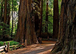
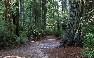
Henry Cowell Redwoods State Park is a state park of California, United States, preserving mainly forest and riparian areas in the watershed of the San Lorenzo River, including a grove of old-growth coast redwood. It is located in Santa Cruz County, primarily in the area between the cities of Santa Cruz and Scotts Valley, near the community of Felton and the University of California at Santa Cruz. The park includes a non-contiguous extension in the Fall Creek area north of Felton. The 4,623-acre (1,871 ha) park was established in 1953.

Waddell Creek is the name given to both the creek and the watershed that run through Big Basin Redwoods State Park in Santa Cruz County, California. The Waddell Creek mainstem is formed by the confluence of East and West Waddell Creeks, and empties into the Pacific Ocean at Waddell Beach, just south of Año Nuevo Point.
Sempervirens Fund, originally established in 1900 as Sempervirens Club, is California's oldest land trust. Founder Andrew P. Hill’s goal was to preserve the old-growth forest that became Big Basin Redwoods State Park, the first California state park in 1902. Sempervirens Fund's mission is to protect and permanently preserve coast redwood forests, wildlife habitat, watersheds, and other important natural features of California's Santa Cruz Mountains, and to encourage people to appreciate and enjoy this environment. Sempervirens Fund does this by purchasing land for protection and transferring it to state or local agencies. Sempervirens Fund has also worked to establish conservation easements and trail linkages between parks and coastal marine preserves. As of 2013, Sempervirens Fund has saved more than 34,000 acres of redwood lands.

Carbonera Creek is a 10.2-mile-long (16.4 km) watercourse in Santa Cruz County, California, that eventually flows to the San Lorenzo River.

The Redwood Grove of Henry Cowell Redwoods State Park, which is located in Santa Cruz County in Northern California, is a grove of Coast Redwoods with trees extending into the 1400- to 1800-year-old range. This grove allows for the use of self-guided tours of the flat, 0.8-mile (1.3 km) loop trail which is easily accessible. Dozens of large, Redwood trees are located within a few feet of the walking trail.

Boulder Creek is a 7.9-mile-long (13 km) stream tributary of the San Lorenzo River in the U.S. state of California. Its drainage basin consists of approximately 11.3 square miles (29.3 km2) of Santa Cruz County. Its main stem begins high in the Santa Cruz Mountains in Big Basin Redwoods State Park. It flows generally south, through the Park and unincorporated community of Boulder Creek, before finally emptying into the San Lorenzo River in the community's downtown.
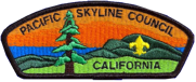
One of the six Boy Scouts of America councils that serves the San Francisco Bay area, the Pacific Skyline Council was founded in 1940 as the Stanford Area Council (#031). In 1994, the Stanford Area Council merged with the San Mateo County Council (#020) to form the current council which serves youth in San Mateo County and northern Santa Clara county.
Zayante is a census-designated place (CDP) in Santa Cruz County, California. It is a residential area located on Zayante Creek. Zayante sits at an elevation of 699 feet (213 m). The 2020 United States census reported Zayante's population was 729.

Wilder Ranch State Park is a California State Park on the Pacific Ocean coast north of Santa Cruz, California. The park was formerly a dairy ranch, and many of the ranch buildings have been restored for use as a museum. There are no campgrounds; a day-use parking lot provides access to the museum. Dogs are prohibited on the trails, but many trails allow bikes and/or horses. The long trails and ocean views make the area a favorite of hikers, equestrians and mountain bikers. Public beaches continue to the north in Coast Dairies State Park.
Rancho Cañada del Rincon en el Rio San Lorenzo was a 5,827-acre (23.58 km2) Mexican land grant in present-day Santa Cruz County, California given in 1843 by Governor Manuel Micheltorena, and confirmed in 1846 by Governor Pío Pico, to Pedro Sainsevain. The name means "valley on a corner on the San Lorenzo River". The grant was north of present-day Santa Cruz on the San Lorenzo River.

The California Powder Works Bridge is a historic covered bridge in Santa Cruz, California. It is a Smith truss bridge, built across the San Lorenzo River in 1872 by the California Powder Works, an explosives manufacturer whose factory complex stood on the river banks. The bridge was designated a National Historic Landmark in 2015 as one of the best-preserved national examples of the Smith truss. It is owned and maintained by the Paradise Park Masonic Club, and is open to pedestrian and vehicular traffic, with a posted weight limit of 5 tons.
Fall Creek is a 5.5-mile-long (8.9 km) southeastward-flowing stream originating on the eastern slopes of Ben Lomond Mountain in the southern Santa Cruz Mountains in Santa Cruz County, before joining the San Lorenzo River, whose waters flow to Monterey Bay and the Pacific Ocean. Fall Creek is regarded as "the most important tributary stream for coho salmon and steelhead trout in the San Lorenzo River watershed."
