
Ore is natural rock or sediment that contains one or more valuable minerals, typically containing metals, that can be mined, treated and sold at a profit. Ore is extracted from the earth through mining and treated or refined, often via smelting, to extract the valuable metals or minerals. The grade of ore refers to the concentration of the desired material it contains. The value of the metals or minerals a rock contains must be weighed against the cost of extraction to determine whether it is of sufficiently high grade to be worth mining, and is therefore considered an ore.
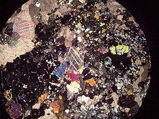
Skarns or tactites are hard, coarse-grained metamorphic rocks that form by a process called metasomatism. Skarns tend to be rich in calcium-magnesium-iron-manganese-aluminium silicate minerals, which are also referred to as calc-silicate minerals. These minerals form as a result of alteration which occurs when hydrothermal fluids interact with a protolith of either igneous or sedimentary origin. In many cases, skarns are associated with the intrusion of a granitic pluton found in and around faults or shear zones that intrude into a carbonate layer composed of either dolomite or limestone. Skarns can form by regional, or contact metamorphism and therefore form in relatively high temperature environments. The hydrothermal fluids associated with the metasomatic processes can originate from either magmatic, metamorphic, meteoric, marine, or even a mix of these. The resulting skarn may consist of a variety of different minerals which are highly dependent on both the original composition of the hydrothermal fluid and the original composition of the protolith.

Chuquicamata is the largest open pit copper mine by excavated volume in the world. It is located in the north of Chile, just outside Calama at 2,850 m (9,350 ft) above sea level, 215 km (134 mi) northeast of Antofagasta and 1,240 km (770 mi) north of the capital, Santiago. Flotation and smelting facilities were installed in 1952, and expansion of the refining facilities in 1968 made 500,000 ton annual copper production possible in the late 1970s. Previously part of Anaconda Copper, the mine is now owned and operated by Codelco, a Chilean state enterprise, since the Chilean nationalization of copper in the late 1960s and early 1970s. Its depth of 850 metres (2,790 ft) makes it the second deepest open-pit mine in the world after Bingham Canyon Mine in Utah, United States.
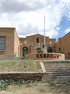
Hillsboro is an unincorporated community in Sierra County, New Mexico, United States, located in the southwestern part of the state. It was founded in 1877, following the discovery of gold. The community was the county seat of Sierra County from 1884 until 1936, when Hot Springs became the county seat.
The Southeast Missouri Lead District, commonly called the Lead Belt, is a lead mining district in the southeastern part of Missouri. Counties in the Lead Belt include Saint Francois; Crawford; Dent; Iron; Madison: Reynolds; and Washington. Philip Francois Renault of France led a large exploratory mission in 1719 and started mining operations in Old Mines and Mine La Motte in 1720. The town of Sainte Genevieve was founded as a river port for transportation of lead out of the area. Moses Austin started large-scale mining and smelting at Potosi, originally known as Mine a Breton, and founded Herculaneum as his shipping point on the Mississippi. This lead was originally used as a roofing material. Bonne Terre has large subterranean mines, now used commercially for recreational scuba diving.

Porphyry copper deposits are copper ore bodies that are formed from hydrothermal fluids that originate from a voluminous magma chamber several kilometers below the deposit itself. Predating or associated with those fluids are vertical dikes of porphyritic intrusive rocks from which this deposit type derives its name. In later stages, circulating meteoric fluids may interact with the magmatic fluids. Successive envelopes of hydrothermal alteration typically enclose a core of disseminated ore minerals in often stockwork-forming hairline fractures and veins. Because of their large volume, porphyry orebodies can be economic from copper concentrations as low as 0.15% copper and can have economic amounts of by-products such as molybdenum, silver, and gold. In some mines, those metals are the main product.
Various theories of ore genesis explain how the various types of mineral deposits form within the Earth's crust. Ore-genesis theories vary depending on the mineral or commodity examined.

A polymetallic replacement deposit, also known as carbonate replacement deposit or high-temperature carbonate-hosted Ag-Pb-Zn deposit, is an orebody of metallic minerals formed by the replacement of sedimentary, usually carbonate rock, by metal-bearing solutions in the vicinity of igneous intrusions. When the ore forms a blanketlike body along the bedding plane of the rock, it is commonly called a manto ore deposit. Other ore geometries are chimneys and veins. Polymetallic replacements/mantos are often stratiform wall-rock replacement orebodies distal to porphyry copper deposits, or porphyry molybdenum deposits. The term manto is from the Spanish word for mantle, or cloak, although the geologic manto is more like a mantle roll than a sheetlike structure.
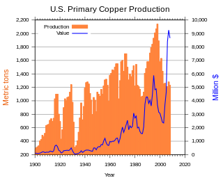
Copper mining in the United States has been a major industry since the rise of the northern Michigan copper district in the 1840s. In 2017 the United States produced 1.27 million metric tonnes of copper, worth $8 billion, making it the world's fourth largest copper producer, after Chile, China, and Peru. Copper was produced from 23 mines in the US. Top copper producing states in 2014 were Arizona, Utah, New Mexico, Nevada, and Montana. Minor production also came from Idaho, and Missouri. As of 2014, the US had 45 million tonnes of known remaining reserves of copper, the fifth largest known copper reserves in the world, after Chile, Australia, Peru, and Mexico.

Uranium mining in Utah, a state of the United States, has a history going back more than 100 years. Uranium mining started as a byproduct of vanadium mining about 1900, became a byproduct of radium mining about 1910, then back to a byproduct of vanadium when the radium price fell in the 1920s. Utah saw a uranium boom in the late 1940s and early 1950s, but uranium mining declined in the 1980s. Since 2001 there has been a revival of interest in uranium mining, as a result of higher uranium prices.
The Safford Mine is an open-pit copper mine located in Graham County, Arizona, eight miles (13 km) north of the city of Safford. The mine is owned and operated by Freeport-McMoran Copper & Gold.
Iron oxide copper gold ore deposits (IOCG) are important and highly valuable concentrations of copper, gold and uranium ores hosted within iron oxide dominant gangue assemblages which share a common genetic origin.

The Robinson Mine is a porphyry copper deposit located at Ruth, White Pine County, Nevada, in the Egan Range, 4 miles (6.4 km) west of Ely. The mine comprises three large open pits: Liberty, Tripp-Veteran and Ruth. The ore is extracted using conventional surface methods, and is then processed into a copper-gold concentrate, and a molybdenum concentrate in a concentrating plant. Since 2012 the mine has been owned and operated by Polish copper miner KGHM Polska Miedź

Los Pelambres mine is a copper mine located in the north-central of Chile in Coquimbo Region. It is one of the largest copper reserves in the world, having estimated reserves of 4.9 billion tonnes of ore grading 0.65% copper.
McNulty rhyolite is one of four intrusive, igneous geological formations, the Chalk Mountain nevadite, Lincoln porphyry, McNulty rhyolite and Quail porphyry, described, mapped, and named by S. F. Emmons in 1898 within the Tenmile Mining District of southern Summit County, Colorado. The McNulty rhyolite, which is also known as the McNulty Gulch rhyolite, is described by S. F. Emmons as a fine-grained porphyritic rhyolite that is light gray in color and contains many small white feldspars and locally some small smoky quartz crystals. He mapped it as being exposed as small irregular masses in McNulty Gulch and southward beyond the area of the Tenmile Mining District that was mapped at the time. One exposure above the Railroad Boy tunnel, his location 45 in McNulty Gulch, exhibited small drusy cavities containing little tablets of tridymite. He proposed that this rhyolite was either intruded contemporaneously withy or later than the Chalk Mountain nevadite at the time of eruption. Based on field mapping, the McNulty rhyolite was interpreted to cross-cut and post-date the Lincoln and the Quail porphyries. Later geologic mapping in the Tenmile Mining District eliminated the McNulty rhyolite as a recognized geologic formation.

Molybdenum mining in the United States produced 65,500 metric tons of molybdenum in 2014, worth US$1.8 billion. The US was the world's second-largest molybdenum producer, after China, and provided 25% of the world's supply of molybdenum.
Farallon Negro is a volcano in the Catamarca province of Argentina. Active between about 9-8 million years ago, it was formerly a stratovolcano or a multi vent volcano. Eventually, erosion removed most of the volcano and exposed the underlying structure including subvolcanic intrusions.
The geology of Arizona began to form in the Precambrian. Igneous and metamorphic crystalline basement rock may have been much older, but was overwritten during the Yavapai and Mazatzal orogenies in the Proterozoic. The Grenville orogeny to the east caused Arizona to fill with sediments, shedding into a shallow sea. Limestone formed in the sea was metamorphosed by mafic intrusions. The Great Unconformity is a famous gap in the stratigraphic record, as Arizona experienced 900 million years of terrestrial conditions, except in isolated basins. The region oscillated between terrestrial and shallow ocean conditions during the Paleozoic as multi-cellular life became common and three major orogenies to the east shed sediments before North America became part of the supercontinent Pangaea. The breakup of Pangaea was accompanied by the subduction of the Farallon Plate, which drove volcanism during the Nevadan orogeny and the Sevier orogeny in the Mesozoic, which covered much of Arizona in volcanic debris and sediments. The Mid-Tertiary ignimbrite flare-up created smaller mountain ranges with extensive ash and lava in the Cenozoic, followed by the sinking of the Farallon slab in the mantle throughout the past 14 million years, which has created the Basin and Range Province. Arizona has extensive mineralization in veins, due to hydrothermal fluids and is notable for copper-gold porphyry, lead, zinc, rare minerals formed from copper enrichment and evaporites among other resources.
Hydrothermal mineral deposits are accumulations of valuable minerals which formed from hot waters circulating in Earth's crust through fractures. They eventually create metallic-rich fluids concentrated in a selected volume of rock, which become supersaturated and then precipitate ore minerals. In some occurrences, minerals can be extracted for a profit by mining. Discovery of mineral deposits consumes considerable time and resources and only about one in every one thousand prospects explored by companies are eventually developed into a mine. A mineral deposit is any geologically significant concentration of an economically useful rock or mineral present in a specified area. The presence of a known but unexploited mineral deposit implies a lack of evidence for profitable extraction.
Michel Jébrak is a Franco-Canadian geologist, academic and a researcher. He is an Emeritus Professor at University of Quebec’s Department of Earth and Atmospheric Sciences. He is a former Vice-Rector for Research and Creation at UQAM and holder of the UQAT-UQAM Mining Entrepreneurship Chair.
