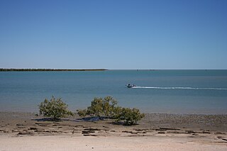
Karumba is a town and a coastal locality in the Shire of Carpentaria, Queensland, Australia. In the 2021 census, the locality of Karumba had a population of 487 people.
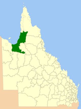
The Shire of Carpentaria is a local government area in Far North Queensland, Australia on the Gulf of Carpentaria, for which it is named.
Minnamoolka is a locality in the Tablelands Region, Queensland, Australia. In the 2021 census, Minnamoolka had a population of 27 people.
Edward River is a rural locality in the Shire of Cook, Queensland, Australia. In the 2021 census, Edward River had "no people or a very low population".
Nicholson is a coastal locality in the Shire of Burke, Queensland, Australia. It is on the border with the Northern Territory. In the 2021 census, Nicholson had a population of 32 people.
Conjuboy is a remote rural locality in the Shire of Etheridge, Queensland, Australia. In the 2021 census, Conjuboy had "no people or a very low population".

Blackbull is a rural locality in the Shire of Croydon, Queensland, Australia. In the 2021 census, Blackbull had "no people or a very low population".

Stokes is an outback locality in the Shire of Carpentaria, Queensland, Australia. In the 2021 census, Stokes had a population of 75 people.

Howitt is a coastal locality in the Shire of Carpentaria, Queensland, Australia. In the 2021 census, Howitt had a population of 48 people.
Fielding is a rural locality in the Shire of Carpentaria, Queensland, Australia. In the 2021 census, Fielding had "no people or a very low population".
Yagoonya is a coastal locality in the Shire of Carpentaria, Queensland, Australia. In the 2021 census, Yagoonya had a population of 20 people.
Gangalidda is a coastal locality in the Aboriginal Shire of Doomadgee, Queensland, Australia, on the Gulf of Carpentaria. In the 2021 census, Gangalidda had "no people or a very low population".
Karron is a locality in the Shire of Croydon, Queensland, Australia. In the 2021 census, Karron had "no people or a very low population".
Shoalwater is a coastal locality in the Livingstone Shire, Queensland, Australia. In the 2021 census, Shoalwater had "no people or a very low population".
Spurgeon is a locality in the Shire of Douglas, Queensland, Australia. In the 2021 census, Spurgeon had "no people or a very low population".
Wharps is a rural locality in the Shire of Hinchinbrook, Queensland, Australia. In the 2021 census, Wharps had "no people or a very low population".
Staaten is a rural locality in the Shire of Mareeba, Queensland, Australia. In the 2021 census, Staaten had "no people or a very low population".
Ravensworth is a rural locality in the Shire of Mareeba, Queensland, Australia. In the 2021 census, Ravensworth had "no people or a very low population".
Esmeralda is a rural locality in the Shire of Croydon, Queensland, Australia. In the 2021 census, Esmeralda had "no people or a very low population".
The West Wellesley Islands, also referred to as the Forsyth Islands, is an island group and locality in the Gulf of Carpentaria within the Shire of Mornington, Queensland, Australia. The group lies to the south-west of the Wellesley Islands, closer to mainland Australia. The island group comprises four islands: Forsyth Island, Ivis Island, Pains Island and Bayley Island.
