Savannah, Queensland

Last updated

Savannah
Queensland
Australia Queensland location map.svg
Red pog.svg
Savannah
Coordinates 19°12′57″S141°52′44″E / 19.2157°S 141.8789°E / -19.2157; 141.8789 Coordinates: 19°12′57″S141°52′44″E / 19.2157°S 141.8789°E / -19.2157; 141.8789
Population0 (2016 census) [1]
 • Density0.00000/km2 (0.0000/sq mi)
Postcode(s) 4816
Area3,956.6 km2 (1,527.7 sq mi)
LGA(s) Shire of Carpentaria
State electorate(s) Traeger
Federal Division(s) Kennedy
Suburbs around Savannah:
Fielding East Creek
Claraville
Esmeralda
Fielding Savannah Victoria Vale
Taldora Malpas-Trenton Malpas-Trenton

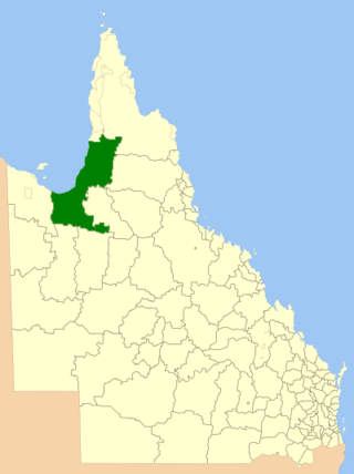
Savannah is a locality in the Shire of Carpentaria, Queensland, Australia. [2] In the 2016 census, Savannah had a population of 0 people. [1]

Suburbs and localities are the names of geographic subdivisions in Australia, used mainly for address purposes. The term locality is used in rural areas, while the term suburb is used in urban areas. Australian postcodes closely align with the boundaries of localities and suburbs.

Shire of Carpentaria Local government area in Queensland, Australia

The Shire of Carpentaria is a local government area in Far North Queensland, Australia on the Gulf of Carpentaria, for which it is named.

Queensland North-east state of Australia

Queensland is the second-largest and third-most populous state in the Commonwealth of Australia. Situated in the north-east of the country, it is bordered by the Northern Territory, South Australia and New South Wales to the west, south-west and south respectively. To the east, Queensland is bordered by the Coral Sea and Pacific Ocean. To its north is the Torres Strait, with Papua New Guinea located less than 200 km across it from the mainland. The state is the world's sixth-largest sub-national entity, with an area of 1,852,642 square kilometres (715,309 sq mi).

Contents

Geography

Savannah is part of the Gulf Country. The Norman River flows through the locality from the west (Victoria Vale) to the north-east (Fielding).

Gulf Country Region in Queensland, Australia

The Gulf Country is the region of woodland and savanna grassland surrounding the Gulf of Carpentaria in north western Queensland and eastern Northern Territory on the north coast of Australia. The region is also called the Gulf Savannah. It contains large reserves of zinc, lead and silver. The Gulf Country is crossed by the Savannah Way highway.

Norman River river in Queensland, Australia

The Norman River is a river in the Gulf Country, Queensland, Australia. The river originates in the Gregory Range 200 km southeast of Croydon, Queensland and flows 420 km northwest to the Gulf of Carpentaria. It is joined by three major tributaries, the Carron, Clara and Yappar Rivers. The river flows through Normanton before entering the Gulf of Carpentaria through the major fishing port of Karumba. The mouth of the river lies in the Gulf Plains Important Bird Area.

Victoria Vale, Queensland Suburb of Shire of Croydon, Queensland, Australia

Victoria Vale is a rural locality in the Shire of Croydon, Queensland, Australia. In the 2016 census, Victoria Vale had a population of 0 people.

Education

There are no schools in the locality or nearby. [3]

Related Research Articles

Normanton, Queensland Town in Queensland, Australia

Normanton is a small cattle town and coastal locality in the Shire of Carpentaria in Queensland, Australia. In the 2016 census, Normanton had a population of 1,210 people of whom 743 were Indigenous Australians.

Doomadgee, Queensland Town in Queensland, Australia

Doomadgee is a town and a locality in the Aboriginal Shire of Doomadgee, Queensland, Australia. In the 2016 census, Doomadgee had a population of 1405 people.

Karumba, Queensland Town in Queensland, Australia

Karumba is a town and a coastal locality in the Shire of Carpentaria, Queensland, Australia. In the 2016 census, Karumba had a population of 531 people.

Burketown Town in Queensland, Australia

Burketown is an isolated outback town and locality in the far north-western Shire of Burke, Queensland, Australia. It is located 898km west of Cairns on the Albert River and Savannah Way in the area known as the Gulf Savannah. The town is the administrative centre of the vast Burke Shire Council. In the 2011 census, Burketown had a population of 201 people.

Shire of Burke Local government area in Queensland, Australia

The Shire of Burke is a local government area in North West Queensland, Australia. The shire lies on the south coast of the Gulf of Carpentaria and abuts the border with the Northern Territory. It covers an area of 40,126.8 square kilometres (15,493.0 sq mi), and has existed as a local government entity since 1885. The major town and administrative centre of the shire is Burketown. The shire and town and the Burke River passing through all are named in honour of ill-fated explorer Robert O'Hara Burke.

Aboriginal Shire of Doomadgee Local government area in Queensland, Australia

The Aboriginal Shire of Doomadgee is a special local government area in North West Queensland, Queensland, Australia. It is managed under a Deed of Grant in Trust under the Local Government Act 2004.

Duchess, Queensland Town in Queensland, Australia

Duchess is a town and a locality in the Shire of Cloncurry, Queensland, Australia.

Minnamoolka, Queensland Suburb of Tablelands Region, Queensland, Australia

Minnamoolka is a locality in the Tablelands Region, Queensland, Australia. In the 2016 census, Minnamoolka had a population of 38 people.

Aboriginal Shire of Mapoon Local government area in Queensland, Australia

The Aboriginal Shire of Mapoon is a local government area in Far North Queensland, Australia. It is on the western coast of Cape York Peninsula on the Gulf of Carpentaria.

Stokes, Queensland Suburb of Shire of Carpentaria, Queensland, Australia

Stokes is a locality in the Shire of Carpentaria, Queensland, Australia. In the 2016 census, Stokes had a population of 84 people.

Burketown, Queensland Town in Queensland, Australia

Burketown is an isolated town and coastal locality in the far north-western Shire of Burke, Queensland, Australia. It is located 898 km west of Cairns on the Albert River and Savannah Way in the area known as the Gulf Savannah. The town is the administrative centre of the vast Burke Shire Council. In the 2011 census, Burketown had a population of 201 people.

Porcupine, Queensland Suburb of Shire of Flinders, Queensland, Australia

Porcupine is a locality in the Shire of Finders, Queensland, Australia. In the 2016 census, Porcupine had a population of 49 people.

Carpentaria, Queensland Suburb of Shire of Carpentaria, Queensland, Australia

Carpentaria is a coastal locality in the Shire of Carpentaria, Queensland, Australia. In the 2016 census, Carpentaria had a population of 14 people.

Howitt, Queensland Suburb of Shire of Carpentaria, Queensland, Australia

Howitt is a coastal locality in the Shire of Carpentaria, Queensland, Australia. In the 2016 census, Howitt had a population of 24 people.

Fielding, Queensland Suburb of Shire of Carpentaria, Queensland, Australia

Fielding is a locality in the Shire of Carpentaria, Queensland, Australia. In the 2016 census, Fielding had a population of 6 people.

Yagoonya, Queensland Suburb of Shire of Carpentaria, Queensland, Australia

Yagoonya is a coastal locality in the Shire of Carpentaria, Queensland, Australia. In the 2016 census, Yagoonya had a population of 25 people.

Maramie, Queensland Suburb of Shire of Carpentaria, Queensland, Australia

Maramie is a locality in the Shire of Carpentaria, Queensland, Australia. In the 2016 census, Maramie had a population of 13 people.

Gangalidda, Queensland Suburb of Aboriginal Shire of Doomadgee, Queensland, Australia

Gangalidda is a coastal locality in the Aboriginal Shire of Doomadgee, Queensland, Australia. In the 2016 census, Gangalidda had a population of 0 people.

Karron, Queensland Suburb of Shire of Croydon, Queensland, Australia

Karron is a locality in the Shire of Croydon, Queensland, Australia. In the 2016 census, Karron had a population of 0 people.

References

  1. 1 2 Australian Bureau of Statistics (27 June 2017). "Savannah (SSC)". 2016 Census QuickStats. Retrieved 20 October 2018. OOjs UI icon edit-ltr-progressive.svg
  2. "Savannah - locality in Shire of Carpentaria (entry 42917)". Queensland Place Names. Queensland Government . Retrieved 27 November 2018.
  3. "Queensland Globe". State of Queensland . Retrieved 17 February 2019.