Related Research Articles

A suburb is an area within a metropolitan area which is predominantly residential and within commuting distance of a large city. Suburbs can have their own political or legal jurisdictions, especially in the United States, but this is not always the case, especially in the United Kingdom, where most suburbs are located within the administrative boundaries of cities. In most English-speaking countries, suburban areas are defined in contrast to central city or inner city areas, but in Australian English and South African English, suburb has become largely synonymous with what is called a "neighborhood" in the U.S. Due in part to historical trends such as white flight, some suburbs in the United States have a higher population and higher incomes than their nearby inner cities.

Smart growth is an urban planning and transportation theory that concentrates growth in compact walkable urban centers to avoid sprawl. It also advocates compact, transit-oriented, walkable, bicycle-friendly land use, including neighborhood schools, complete streets, and mixed-use development with a range of housing choices. The term "smart growth" is particularly used in North America. In Europe and particularly the UK, the terms "compact city", "urban densification" or "urban intensification" have often been used to describe similar concepts, which have influenced government planning policies in the UK, the Netherlands and several other European countries.

New Urbanism is an urban design movement that promotes environmentally friendly habits by creating walkable neighbourhoods containing a wide range of housing and job types. It arose in the United States in the early 1980s, and has gradually influenced many aspects of real estate development, urban planning, and municipal land-use strategies. New Urbanism attempts to address the ills associated with urban sprawl and post-WW II suburban development.
The history of Melbourne details the city's growth from a fledgling settlement into a modern commercial and financial centre as Australia's second largest city, Melbourne, in the state of Victoria.

Urban sprawl is defined as "the spreading of urban developments on undeveloped land near a city". Urban sprawl has been described as the unrestricted growth in many urban areas of housing, commercial development, and roads over large expanses of land, with little concern for very dense urban planning. Sometimes the urban areas described as the most "sprawling" are the most densely populated. In addition to describing a special form of urbanization, the term also relates to the social and environmental consequences associated with this development. In modern times some suburban areas described as "sprawl" have less detached housing and higher density than the nearby core city. Medieval suburbs suffered from the loss of protection of city walls, before the advent of industrial warfare. Modern disadvantages and costs include increased travel time, transport costs, pollution, and destruction of the countryside. The revenue for building and maintaining urban infrastructure in these areas are gained mostly through property and sales taxes. Most jobs in the US are now located in suburbs generating much of the revenue, although a lack of growth will require higher tax rates.

Victoria has the highest density of roads of any state in Australia. Unlike Australia's other mainland states, which have vast areas with virtually no residents, Victoria has population centres spread out over most of the state, with only the far north-west and the Victorian Alps without significant settlements. Population centres are linked by high quality highways and freeways. The state capital, Melbourne, has the most extensive freeway network of any city in Australia.
In urban planning, transit-oriented development (TOD) is a type of urban development that maximizes the amount of residential, business and leisure space within walking distance of public transport. It promotes a symbiotic relationship between dense, compact urban form and public transport use. In doing so, TOD aims to increase public transport ridership by reducing the use of private cars and by promoting sustainable urban growth.
Cranbourne East is a suburb in Melbourne, Victoria, Australia, 45 km south-east of Melbourne's Central Business District, located within the City of Casey local government area. Cranbourne East recorded a population of 24,679 at the 2021 census.
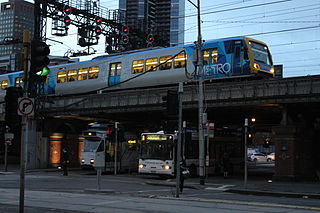
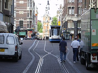
Transport in Melbourne, the state capital of Victoria, Australia, consists of several interlinking modes. Melbourne is a hub for intercity, intracity and regional travel. Road-based transport accounts for most trips across many parts of the city, facilitated by Australia's largest freeway network. Public transport, including the world's largest tram network, trains and buses, also forms a key part of the transport system. Other dominant modes include walking, cycling and commercial-passenger vehicle services such as taxis.

Mixed use is a type of urban development, urban design, urban planning and/or a zoning classification that blends multiple uses, such as residential, commercial, cultural, institutional, or entertainment, into one space, where those functions are to some degree physically and functionally integrated, and that provides pedestrian connections. Mixed-use development may be applied to a single building, a block or neighborhood, or in zoning policy across an entire city or other administrative unit. These projects may be completed by a private developer, (quasi-)governmental agency, or a combination thereof. A mixed-use development may be a new construction, reuse of an existing building or brownfield site, or a combination.

Melbourne 2030 is a Victoria State Government strategic planning policy framework for the metropolitan area of Melbourne, Australia intended to cover the period 2001–2030. During this period the population of the metropolitan area is expected to grow by a million people to over five million. Population projections now predict Melbourne's population could reach seven million by that time and the government has since changed its strategy on the policy, abandoning the urban growth boundary in the north and west of Melbourne and reducing green wedges.

The Melbourne central business district is the city centre of Melbourne, Victoria, Australia. As of the 2021 census, the CBD had a population of 54,941, and is located primarily within the local government area City of Melbourne, with some parts located in the City of Port Phillip.
Neighborhood character refers to the 'look and feel of an area', in particular a residential area. It also includes the activities that occur there. In everyday usage, it can often be synonymous with local character, residential character, urban character and place identity, but those terms can have more specific meanings in connection with urban planning and conservation.
Activity centre is a term used in urban planning and design for a mixed-use urban area where there is a concentration of commercial and other land uses. For example, the central business districts of cities (CBD) are also known as “Central Activities Districts” (CAD) (also known as Downtown in North America or "Central Activities Zone" in the United Kingdom, in recognition of the fact that commercial functions are not the only things that occur there. The term activity centre can also be used to designate an area for mixed-use development, whatever its current land use happens to be.

Car dependency is a phenomenon in urban planning wherein existing and planned infrastructure prioritizes the use of automobiles over other modes of transportation, such as public transport, bicycles, and walking. Car dependency has been attributed with leading to a more polluting transport system compared to systems where all transportation modes are treated more equally.
Urban consolidation describes the policy of constraining further development and population growth to within the boundaries of preexisting urban areas rather than expanding outward into suburban areas. Urban consolidation seeks to increase the population density of a given urban area by expanding upward, redeveloping preexisting buildings and lots, and constructing new facilities in available spaces. It is theorized that discouraging urban sprawl and encouraging further development of housing units in preexisting urban areas will lead to a net gain in social and economic prosperity.
ResCode is a residential design code introduced by the Bracks (ALP) government, in Victoria, Australia in 2001. It applies to all land zoned for residential use across Victoria and covers buildings up to and including four storeys in height.

Medium-density housing is a term used within urban planning and academic literature to refer to a category of residential development that falls between detached suburban housing and large multi-story buildings. There is no singular definition of medium-density housing as its precise definition tends to vary between jurisdiction. Scholars however, have found that medium density housing ranges from about 25 to 80 dwellings per hectare, although most commonly sits around 30 and 40 dwellings/hectare. Typical examples of medium-density housing include duplexes, triplexes, townhouses, row homes, detached homes with garden suites, and walk-up apartment buildings.

Melbourne is the capital and most populous city of the Australian state of Victoria, and the second-most populous city in Australia, after Sydney. The city's name generally refers to a 9,993 km2 (3,858 sq mi) metropolitan area also known as Greater Melbourne, comprising an urban agglomeration of 31 local government areas. The name is also used to specifically refer to the local government area named City of Melbourne, whose area is centred on the Melbourne central business district and some immediate surrounds.
Urban planning in Australia has a significant role to play in ensuring the future sustainability of Australian cities. Australia is one of the most highly urbanised societies in the world. Continued population growth in Australian cities is placing increasing pressure on infrastructure, such as public transport and roadways, energy, air and water systems within the urban environment.
References
- Lewis, M. (1999) Suburban backlash : the battle for the world's most liveable city, Hawthorn, Vic. : Bloomings Books, ( ISBN 1876473169)