Schkopau

Last updated
Schkopau
Schlosshotel Schkopau (3309103015).jpg
Schkopau Castle
Wappen Schkopau bis 2004.png
Location of Schkopau within Saalekreis district
Schkopau in SK.svgLandsbergPetersberg
Germany adm location map.svg
Red pog.svg
Schkopau
Saxony-Anhalt location map.svg
Red pog.svg
Schkopau
Coordinates: 51°23′N11°58′E / 51.383°N 11.967°E / 51.383; 11.967
Country Germany
State Saxony-Anhalt
District Saalekreis
Government
   Mayor (201825) Torsten Ringling [1]
Area
  Total90.66 km2 (35.00 sq mi)
Elevation
98 m (322 ft)
Population
 (2021-12-31) [2]
  Total10,937
  Density120/km2 (310/sq mi)
Time zone UTC+01:00 (CET)
  Summer (DST) UTC+02:00 (CEST)
Postal codes
06258
Dialling codes 03461
Vehicle registration SK
Website www.gemeinde-schkopau.de

Schkopau is a municipality in the Saalekreis district, in Saxony-Anhalt, Germany.

Contents

Geography

It is situated at the confluence of the Saale River with its White Elster and Luppe tributaries, approx. 6 kilometres (3.7 mi) north of Merseburg, and 10 km (6.2 mi) south of Halle.

Streetcar in Schkopau Schkopau Strassenbahn.jpg
Streetcar in Schkopau

Schkopau station is a stop on the Thuringian Railway line from Halle to Eisenach. Another connection is provided by an interurban tramway line from Halle to Bad Dürrenberg. Beside the resident chemical industry, the municipality is the site of the Schkopau Power Station, a brown coal power plant run by the E.ON electric utility.

The municipal area comprises the localities of Burgliebenau, Döllnitz, Ermlitz, Hohenweiden, Knapendorf, Korbetha, Lochau, Luppenau, Raßnitz, Röglitz, Schkopau, and Wallendorf.

History

A Scapowe Castle was first mentioned in an 1177 deed. Already in the ninth century, a Carolingian fortress had been erected on the Saale River, then the eastern border of East Francia with the lands of the Polabian Slavs.


In 1215, King Frederick II endowed it to the Archbishop of Magdeburg, who already held the nearby town of Halle. Enfeoffed to the Bishop of Merseburg in 1444 and held by the Trotha noble family from 1477 onwards, the castle was rebuilt several times, recently in 1876 in a Renaissance Revival style. Today it is used as a hotel.

Schkopau castle courtyard Schkopau castle, view from the courtyard.jpg
Schkopau castle courtyard

In April 1936, the Buna (i.e. butadiene-natrium polymer) synthetic rubber company was established in Schkopau, part of the Nazi efforts to make German economy self-sufficient in view of coming World War II. The Schkopau works were a subsidiary of the Leuna chemical company, itself part of the vast IG Farben industry conglomerate. Production started in 1937; beside rubber it included polyvinyl chloride (PVC), trichloroethylene, formaldehyde, tetrahydrofuran (THF), acetic acid and acetic anhydride, as well as acetone.

During the war, the Schkopau plant was the greatest producer of Axis synthetic rubber (>17%). [3] It ran the Buna Werke branch in Oświęcim, where the Monowitz concentration camp (Auschwitz III) was erected, a labor camp ( Arbeitslager ) with numerous forced labourers working under cruel treatment.

Schkopau Buna plant, 1953 Bundesarchiv Bild 183-22015-013, SAG-Betrieb Buna in Schkopau.jpg
Schkopau Buna plant, 1953

After the war, the Schkopau plant was seized by the Soviet Military Administration in Germany and re-organised as a Publicly Owned Operation (Volkseigener Betrieb, VEB) of East Germany. The VEB Chemische Werke Buna combine, the world's largest producer of carbide in 1958, became known for its Plaste und Elaste products but also for outdated production facilities and heavy industrial pollution. Taken over by the East German Treuhand agency upon the Peaceful Revolution in 1989, it is today a subsidiary of the Dow Chemical Company.

Politics

Seats in the municipal assembly as of 2009 elections:

Schkopau municipal logo with stylized flask Logo2 der Gemeinde Schkopau.gif
Schkopau municipal logo with stylized flask

The current mayor is Torsten Ringling, elected in October 2018. [1]

People

Related Research Articles

<span class="mw-page-title-main">Merseburg</span> Town in Saxony-Anhalt, Germany

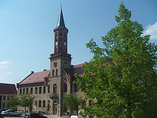
Merseburg is a town in central Germany in southern Saxony-Anhalt, situated on the river Saale, and approximately 14 km south of Halle (Saale) and 30 km west of Leipzig. It is the capital of the Saalekreis district. It had a diocese founded by Archbishop Adalbert of Magdeburg. The University of Merseburg is located within the town. Merseburg has around 35,000 inhabitants.

<span class="mw-page-title-main">Saxony-Anhalt</span> State in Germany

Saxony-Anhalt is a state of Germany, bordering the states of Brandenburg, Saxony, Thuringia and Lower Saxony. It covers an area of 20,451.7 square kilometres (7,896.4 sq mi) and has a population of 2.17 million inhabitants, making it the 8th-largest state in Germany by area and the 11th-largest by population. Its capital is Magdeburg and its largest city is Halle (Saale).

<span class="mw-page-title-main">Lützen</span> Town in Saxony-Anhalt, Germany

Lützen  is a town in the Burgenlandkreis district of Saxony-Anhalt, Germany.

<span class="mw-page-title-main">Zeitz</span> Town in Saxony-Anhalt, Germany

Zeitz is a town in the Burgenlandkreis district, in Saxony-Anhalt, Germany. It is situated on the river White Elster, in the triangle of the federal states Saxony-Anhalt, Thuringia and Saxony.

<span class="mw-page-title-main">Leuna</span> Town in Saxony-Anhalt, Germany

Leuna is a town in Saxony-Anhalt, eastern Germany, south of Merseburg and Halle, on the river Saale.

<span class="mw-page-title-main">Weißenfels</span> Town in Saxony-Anhalt, Germany

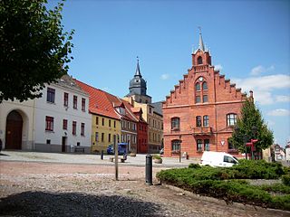
Weißenfels is the largest town of the Burgenlandkreis district, in southern Saxony-Anhalt, central Germany. It is situated on the river Saale, approximately 30 km (20 mi) south of Halle.

<span class="mw-page-title-main">Bernburg</span> Town in Saxony-Anhalt, Germany

Bernburg (Saale) is a town in Saxony-Anhalt, Germany, capital of the Salzlandkreis district. The former residence of the Anhalt-Bernburg princes is known for its Renaissance castle.

Buna may refer to:

<span class="mw-page-title-main">Bad Lauchstädt</span> Town in Saxony-Anhalt, Germany

Bad Lauchstädt , officially Goethestadt Bad Lauchstädt, is a town in the district Saalekreis, Saxony-Anhalt, Germany, 13 km southwest of Halle. Population 8,781 (2020).

<span class="mw-page-title-main">Landsberg, Saxony-Anhalt</span> Town in Saxony-Anhalt, Germany

Landsberg is a town in the Saalekreis in the state of Saxony-Anhalt, Germany

<span class="mw-page-title-main">Könnern</span> Town in Saxony-Anhalt, Germany

Könnern  is a town in the district of Salzlandkreis, in Saxony-Anhalt, Germany. It is situated on the right bank of the river Saale, approx. 15 km south of Bernburg, and 25 km northwest of Halle (Saale).

<span class="mw-page-title-main">Alsleben</span> Town in Saxony-Anhalt, Germany

Alsleben is a town in the district of Salzlandkreis, in Saxony-Anhalt, Germany. It is situated on the river Saale, south of Bernburg. It is part of the Verbandsgemeinde Saale-Wipper.

<span class="mw-page-title-main">Zörbig</span> Town in Saxony-Anhalt, Germany

Zörbig is a town in the district of Anhalt-Bitterfeld in Saxony-Anhalt, Germany. It is situated approximately 15 km west of Bitterfeld, and 20 km northeast of Halle (Saale). Zörbig is well known for its molasses made from sugar beets.

<span class="mw-page-title-main">Bad Dürrenberg</span> Town in Saxony-Anhalt, Germany

Bad Dürrenberg is a spa town in the Saalekreis district, in Saxony-Anhalt, Germany. It is situated on the river Saale, approx. 8 km southeast of Merseburg. It is known for its graduation tower, the largest one in Germany.

<span class="mw-page-title-main">Schraplau</span> Town in Saxony-Anhalt, Germany

Schraplau is a town in the Verbandsgemeinde Weida-Land, part of the district of Saalekreis, in the State of Sachsen-Anhalt, Germany. It is situated approximately 8 km (5 mi) northeast of Querfurt. It is also considered part of the Halle-Leipzig metropolitan area.

<span class="mw-page-title-main">Kabelsketal</span> Municipality in Saxony-Anhalt, Germany

Kabelsketal is a municipality in the Saalekreis district, in Saxony-Anhalt, Germany. It is situated east of Halle (Saale). It was formed in 2004 out of the villages of Dieskau, Dölbau, Gröbers und Großkugel.

Saalekreis is a district in Saxony-Anhalt, Germany. The district seat is Merseburg. Its area is 1,434.2 km2 (553.7 sq mi). It is bounded by the districts Kyffhäuserkreis (Thuringia), Mansfeld-Südharz, Salzlandkreis, Anhalt-Bitterfeld, Nordsachsen, Leipzig and Burgenlandkreis. The district-free city of Halle is surrounded by the Saalekreis.

<span class="mw-page-title-main">Arzberg, Saxony</span> Municipality in Saxony, Germany

Arzberg is a municipality in the district Nordsachsen, in Saxony, Germany.

<span class="mw-page-title-main">Middle German Chemical Triangle</span>

The Middle German Chemical Triangle is the industrial conurbation around the cities and towns of Halle (Saale), Merseburg and Bitterfeld in the North German state of Saxony-Anhalt and Leipzig and Schkeuditz in the Free State of Saxony. Its name is derived from the dominant industries of the region – the chemical and oil refining industries.

Buna Werke Schkopau were a chemical company specialising in the production of polymer materials such as plastics and artificial rubber. The name BUNA is derived from the technology of polymerising butadiene with sodium as a catalyst.

References

  1. 1 2 Bürgermeisterwahlen in den Gemeinden, Endgültige Ergebnisse, Statistisches Landesamt Sachsen-Anhalt, accessed 8 July 2021.
  2. "Bevölkerung der Gemeinden – Stand: 31. Dezember 2021" (PDF) (in German). Statistisches Landesamt Sachsen-Anhalt. June 2022.
  3. Stormont, John W. (March 1946) [summer of 1945]. AAFRH-19: The Combined Bomber Offensive; April through December 1943. Dwight D. Eisenhower Presidential Library: Collection of 20th Century Military Records, 1918-1950 Series I: Historical Studies Box 35: AAF Historical Office; Headquarters, Army Air Force. pp. 74–5, 81. SECRET ... Classification Cancelled ... JUN 10 1959{{cite book}}: CS1 maint: location (link)