Landsberg, Saxony-Anhalt

Last updated
Landsberg
LandsbergBlickKap.jpg
Old town, view from Chapel Hill
Wappen Landsberg (Saalekreis).png
Location of Landsberg within Saalekreis district
Landsberg in SK.svgLandsbergPetersberg
Germany adm location map.svg
Red pog.svg
Landsberg
Saxony-Anhalt location map.svg
Red pog.svg
Landsberg
Coordinates: 51°32′N12°10′E / 51.533°N 12.167°E / 51.533; 12.167 Coordinates: 51°32′N12°10′E / 51.533°N 12.167°E / 51.533; 12.167
Country Germany
State Saxony-Anhalt
District Saalekreis
Subdivisions11
Government
   Mayor (201825) Anja Werner [1] (SPD)
Area
  Total124.74 km2 (48.16 sq mi)
Elevation
97 m (318 ft)
Population
 (2020-12-31) [2]
  Total15,068
  Density120/km2 (310/sq mi)
Time zone UTC+01:00 (CET)
  Summer (DST) UTC+02:00 (CEST)
Postal codes
06186–06188
Dialling codes 034602
Vehicle registration SK
Website www.stadt-landsberg.de

Landsberg is a town in the Saalekreis in the state of Saxony-Anhalt, Germany

Contents

Geography

The town is located between the cities of Halle, about 19 km (12 mi) in the southwest, Leipzig, about 25 km (16 mi) in the southeast, and Bitterfeld-Wolfen, about 15 km (9.3 mi) in the north. Located in the Leipzig Bay of the North German Plain, Landsberg lies within the larger Leipzig-Halle agglomeration in the Central German Metropolitan Region.

The municipal area immediately borders the independent city of Halle in the southwest and the Nordsachsen district of Saxony in the southeast. After several incorporations in recent years, it currently comprises 11 localities (Ortschaften): [3]

Known far beyond Landsberg is the Felsenbad ("Cliff Bath"), a swimming pool complex with diving platforms, a 50-metre (160 ft) stretch of competition swimming lanes, and a vast shallow pool where non-swimmers may bathe. Furthermore, the town is the namesake of the well known – in Germany – Landsberger Gemenge (roughly "Landsberg Batch"), a winter catch crop made out of crimson clover, Italian ryegrass and fodder vetch, which is used as livestock fodder or silage.

Landsberg station is a stop on the Berlin–Halle railway, Halle–Cottbus railway, and Magdeburg-Leipzig railway lines.

History

The oldest known trace of early settlements in what is now Landsberg dates from the Neolithic. It is first documented as civitas holm in a 961 deed issued by King Otto I of Germany, then located in the Slavic lands beyond the southeastern borders of the Duchy of Saxony along the Saale River.

Landsberg Double Chapel Doppelkapelle Landsberg9.jpg
Landsberg Double Chapel

Landsberg Castle from the 12th century onwards was the seat of the Margraves of Landsberg. Held by the Saxon noble House of Wettin, it was rebuilt when Margrave Conrad of Meissen ceded the March of Lusatia with Landsberg to his son Theodoric I in 1156. A loyal follower of the Hohenstaufen emperor Frederick Barbarossa, Theoderic accompanied him on his Italian campaign of 1176/77 against the cities of the Lombard League and witnessed the peace negotiations leading to the Treaty of Venice. Back in Germany, he had a Staufian double chapel erected on the Landsberg castle hill. Built in a Romanesque style up on a cliff and visible even far from the town, it is one of Landsberg's landmarks up to today.

When the Wettin margrave Henry III of Meissen about 1258 re-established the Margraviate of Landsberg for his second son Theodoric, Landsberg Castle had already lost its status as the margravial residence to Weißenfels. Upon the death of Theoderic's son Frederick Tuta in 1291, Landsberg fell to the Ascanian margrave Otto IV of Brandenburg. During decades of feuds between the Wettin and Ascanian dynasties the castle decayed and today only traces of wall remain.

The settlement at the foot of the castle arose around the St Nicholas parish church dating from the 13th century. In 1579, the citizens of Landsberg were granted town privileges by the Saxon electors, though on condition not to erect city fortifications. Severely damaged during the Thirty Years' War, the Landsberg double chapel about 1658/62 was restored at the behest of the Wettin duke Christian I of Saxe-Merseburg.

In 2019, two people were killed and two others were injured in a terrorist attack in the city of Halle. Two of the injuries occurred in the city of Landsberg. [4]

Coat of arms

The town's coat of arms, called "Landsberg Pales" (Landsberger Pfähle) according to heraldic blazon, is first known to have appeared in the late 12th century, and the margraves of the Wettin dynasty, local rulers since the 10th century, used it as their arms. [5] The blue Landsberg Pales appear on the coat of arms of numerous towns and cities in Central Germany, such as Chemnitz, Dresden (in black), and Leipzig.

Related Research Articles

<span class="mw-page-title-main">Merseburg</span> Town in Saxony-Anhalt, Germany

Merseburg is a town in central Germany located in the southern part of Saxony-Anhalt on the river Saale, approximately 14 km south of Halle (Saale) and 30 km west of Leipzig. It is the capital of the Saalekreis district. It had a diocese founded by Archbishop Adalbert of Magdeburg. The University of Merseburg is located within the town. Merseburg has around 33,000 inhabitants. Merseburg is part of the Central German Metropolitan Region.

<span class="mw-page-title-main">Saxony</span> State in Germany

Saxony, officially the Free State of Saxony, is a landlocked state of Germany, bordering the states of Brandenburg, Saxony-Anhalt, Thuringia, Bavaria, as well as the countries of Poland and the Czech Republic. Its capital is Dresden, and its largest city is Leipzig. Saxony is the tenth largest of Germany's sixteen states, with an area of 18,413 square kilometres (7,109 sq mi), and the sixth most populous, with more than 4 million inhabitants.

<span class="mw-page-title-main">Colditz</span> Town in Saxony, Germany

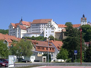
Colditz is a small town in the district of Leipzig, in Saxony, Germany. It is best known for Colditz Castle, the site of the Oflag IV-C POW camp for officers in World War II.

<span class="mw-page-title-main">Lützen</span> Town in Saxony-Anhalt, Germany

Lützen  is a town in the Burgenlandkreis district of Saxony-Anhalt, Germany.

<span class="mw-page-title-main">House of Wettin</span> German noble and royal family

The House of Wettin is a dynasty of German counts, dukes, prince-electors and kings that once ruled territories in the present-day German states of Saxony, Saxony-Anhalt and Thuringia. The dynasty is one of the oldest in Europe, and its origins can be traced back to the town of Wettin, Saxony-Anhalt. The Wettins gradually rose to power within the Holy Roman Empire. Members of the family became the rulers of several medieval states, starting with the Saxon Eastern March in 1030. Other states they gained were Meissen in 1089, Thuringia in 1263, and Saxony in 1423. These areas cover large parts of Central Germany as a cultural area of Germany.

<span class="mw-page-title-main">Nebra (Unstrut)</span> Town in Saxony-Anhalt, Germany

Nebra is a town in the district of Burgenlandkreis of Saxony-Anhalt, Germany. It is situated on the river Unstrut. Nebra has become nationally and internationally known as the site where the Nebra sky disc, a notable Bronze Age artifact, was discovered. The town has a population of around 3,300.

<span class="mw-page-title-main">Delitzsch</span> Town in Saxony, Germany

Delitzsch is a town in the Free State of Saxony in Germany, 20 km north of Leipzig and 30 km east of Halle (Saale). With 24,850 inhabitants at the end of 2015, it is the largest town in the district of Nordsachsen.

<span class="mw-page-title-main">Ballenstedt</span> Town in Saxony-Anhalt, Germany

Ballenstedt is a town in the Harz district, in the German state of Saxony-Anhalt.

<span class="mw-page-title-main">Dohna</span> Town in Saxony, Germany

Dohna is a town in the Sächsische Schweiz-Osterzgebirge district, Saxony, Germany. It is located south of Heidenau, in the Müglitz valley and lies at the northeastern foot of the Eastern Ore Mountains. It is accessed by the Pirna interchange of highway A17, and by the Dohna (Sachs) and Köttewitz stations of the Müglitz Valley Railway.

<span class="mw-page-title-main">Henry III, Margrave of Meissen</span> Margrave of Meissen

Henry III, called Henry the Illustrious from the House of Wettin was Margrave of Meissen and last Margrave of Lusatia from 1221 until his death; from 1242 also Landgrave of Thuringia.

<span class="mw-page-title-main">Schraplau</span> Town in Saxony-Anhalt, Germany

Schraplau is a town in the Verbandsgemeinde Weida-Land, part of the district of Saalekreis, in the State of Sachsen-Anhalt, Germany. It is situated approximately 8 km (5 mi) northeast of Querfurt. It is also considered part of the Halle-Leipzig metropolitan area.

<span class="mw-page-title-main">Margraviate of Landsberg</span> German march in Saxony-Anhalt (1261–1347)

The Margraviate of Landsberg was a march of the Holy Roman Empire that existed from the 13th to the 14th century under the rule of the Wettin dynasty. It was named after Landsberg Castle in present-day Saxony-Anhalt.

Conrad I, called the Great, a member of the House of Wettin, was Margrave of Meissen from 1123 and Margrave of Lusatia from 1136 until his retirement in 1156. Initially a Saxon count, he became the ruler over large Imperial estates in the Eastern March and progenitor of the Saxon electors and kings.

<span class="mw-page-title-main">March of Lusatia</span> March of the Holy Roman Empire (965–1367)

The March or Margraviate of Lusatia was as an eastern border march of the Holy Roman Empire in the lands settled by Polabian Slavs. It arose in 965 in the course of the partition of the vast Marca Geronis. Ruled by several Saxon margravial dynasties, among them the House of Wettin, the lordship was contested by the Polish kings as well as by the Ascanian margraves of Brandenburg. The remaining territory was finally incorporated into the Lands of the Bohemian Crown in 1367.

Saalekreis is a district in Saxony-Anhalt, Germany. The district seat is Merseburg. It is bounded by the districts Kyffhäuserkreis (Thuringia), Mansfeld-Südharz, Salzlandkreis, Anhalt-Bitterfeld, Nordsachsen, Leipzig and Burgenlandkreis. The district-free city of Halle is surrounded by the Saalekreis.

<span class="mw-page-title-main">Wettin-Löbejün</span> Town in Saxony-Anhalt, Germany

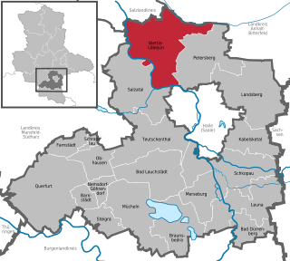
Wettin-Löbejün is a town in the district Saalekreis, in Saxony-Anhalt, Germany. It was formed on 1 January 2011 by the almagamation of the former municipalities Löbejün, Wettin, Brachwitz, Döblitz, Domnitz, Gimritz, Nauendorf, Neutz-Lettewitz, Plötz and Rothenburg. These former municipalities and Dößel are now the 11 Ortschaften or municipal divisions of the town.

Theodoric of Landsberg, a member of the House of Wettin was Margrave of Landsberg from 1265 until his death.

Frederick Tuta, a member of the House of Wettin, was Margrave of Landsberg from 1285 and Margrave of Lusatia from 1288 until his death. He also served as regent of the Margraviate of Meissen.

Margrave Conrad II of Lusatia, also known as Margrave Konrad II of Landsberg, was a member of the House of Wettin. He was Count of Eilenburg and Margrave of Lusatia from 1190 until his death. From 1207, he was also Count of Groitz and Count of Sommerschenburg. He was a son of Margrave Dedi III and his wife, Matilda of Heinsberg, the heiress of Sommerschenburg.

References

  1. Bürgermeisterwahlen in den Gemeinden, Endgültige Ergebnisse, Statistisches Landesamt Sachsen-Anhalt, accessed 8 July 2021.
  2. "Bevölkerung der Gemeinden – Stand: 31. Dezember 2020" (PDF). Statistisches Landesamt Sachsen-Anhalt (in German). June 2021.
  3. Hauptsatzung der Stadt Landsberg, January 2020.
  4. Zeitung, Süddeutsche. "Anschlag in Halle: Opfer sind identifiziert". Süddeutsche.de (in German). Retrieved 2022-07-26.
  5. Heraldrywiki