Scurry, Texas

Last updated

Scurry, Texas
Kaufman County Texas Incorporated Areas Scurry highlighted.svg
Location of Scurry in Kaufman County, Texas
Coordinates: 32°30′25″N96°23′10″W / 32.50694°N 96.38611°W / 32.50694; -96.38611
Country United States
State Texas
Counties Kaufman
Area
[1]
  Total
1.93 sq mi (4.99 km2)
  Land1.93 sq mi (4.99 km2)
  Water0.00 sq mi (0.00 km2)
Elevation
[2]
420 ft (130 m)
Population
 (2020)
  Total
688
  Density360/sq mi (140/km2)
Time zone UTC-6 (Central (CST))
  Summer (DST) UTC-5 (CDT)
ZIP Code
75158
Area codes 214, 469, 945, 972
FIPS Code 48-66368
GNIS feature ID2413268 [2]
Website tshaonline.org/handbook/online/articles/hls33

Scurry is a town in Kaufman County, Texas, United States. It was incorporated in 2003. [3] As of the 2020 census, it had a population of 688.

Contents

Scurry is named after Scurry Dean. The arrival of the Texas and Pacific Railway in the 1870s established the settlement as a shipment point for area farmers. When local residents requested a post office, they submitted the name Scurry – in honor of Scurry Dean, who was killed during the Civil War. Post service began in 1883 and a year later, Scurry had an estimated population of fifty.

Geography

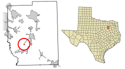
Scurry is located along State Highway 34 in southwestern Kaufman County, 7 miles (11 km) southwest of Kaufman and 34 miles (55 km) southeast of Dallas. [4]

According to the U.S. Census Bureau, the town has an area of 1.9 square miles (5.0 km2), all land. [5]

Climate

The climate in this area is characterized by hot, humid summers and generally mild to cool winters. According to the Köppen climate classification, Scurry has a humid subtropical climate, Cfa on climate maps. [6]

History

The first settlers in the area arrived in the mid-1840s. Over the next quarter century, a church and school community developed and the number of farms increased. The arrival of the Texas and Pacific Railway in the 1870s established the settlement as a shipment point for area farmers. When local residents requested a post office, they submitted the name "Scurry"—in honor of Scurry Dean, who was killed during the Civil War. Postal service began in 1883, and a year later, Scurry had an estimated population of 50. [4] By 1914, the community was home to around 400 people and a number of businesses. The Great Depression caused Scurry to decline, which lasted through the first decade after World War II. Only 250 people remained in the community by the mid-1950s. The trend was reversed during the latter half of the 20th century. In 1990, 9 businesses and about 315 people were living in the community. [7] That figure approached 600 by 2000, and Scurry was officially incorporated as a town three years later.

Demographics

Historical population
CensusPop.Note
1990 315
2000 60090.5%
2010 68113.5%
2020 6881.0%
U.S. Decennial Census [8]
2020 Census [9]

Education

Public education in the town of Scurry is provided by the Scurry-Rosser Independent School District. [10] The district has three campuses and also serves the incorporated communities of Rosser, Cottonwood, and Grays Prairie in southwestern Kaufman County.

References

  1. "2019 U.S. Gazetteer Files". United States Census Bureau. Retrieved August 7, 2020.
  2. 1 2 U.S. Geological Survey Geographic Names Information System: Scurry, Texas
  3. "Boundary Changes". Geographic Change Notes: Texas. Population Division, United States Census Bureau. May 19, 2006. Archived from the original on February 6, 2006. Retrieved May 27, 2008.
  4. 1 2 "Scurry, Texas". Texas Escapes Online Magazine. Retrieved August 19, 2009.
  5. "Geographic Identifiers: 2010 Census Summary File 1 (G001), Scurry town, Texas". American FactFinder. U.S. Census Bureau. Archived from the original on February 13, 2020. Retrieved May 6, 2019.
  6. Climate Summary for Scurry, Texas
  7. "Scurry, Texas". The Handbook of Texas online. Retrieved August 19, 2009.
  8. "Census of Population and Housing". Census.gov. Retrieved June 4, 2015.
  9. "Census Bureau profile: Scurry, Texas". United States Census Bureau. May 2023. Retrieved May 21, 2024.
  10. Geography Division (December 22, 2020). 2020 CENSUS - SCHOOL DISTRICT REFERENCE MAP: Kaufman County, TX (PDF) (Map). U.S. Census Bureau. Archived (PDF) from the original on October 9, 2022. Retrieved July 21, 2025. - Text list