
La Prairie is a village in Adams County, Illinois, United States. The population was 42 at the 2020 census. It is part of the Quincy, IL–MO Micropolitan Statistical Area.

Chebanse is a village in Iroquois and Kankakee counties in the U.S. state of Illinois. The population was 1,044 at the 2020 census. The Kankakee County portion of Chebanse is included in the Kankakee-Bradley, Illinois Metropolitan Statistical Area.

Prairie Grove is a village in McHenry County, Illinois, United States, first incorporated in 1973. Per the 2020 census, the population was 1,963.

Burnt Prairie is a village in White County, Illinois, United States. The population was 58 at the 2000 census.

Prairie Village is a city in Johnson County, Kansas, United States, and located within the Kansas City Metropolitan Area. As of the 2020 census, the population of the city was 22,957.

Parkers Prairie is a city in Otter Tail County, Minnesota, United States. The population was 1,020 at the 2020 census.

Louisburg is a village in Dallas County, Missouri, United States. The population was 122 at the 2010 census. It is part of the Springfield, Missouri Metropolitan Statistical Area.
Bailey's Prairie is a village in Brazoria County in the southeastern portion of the U.S. state of Texas. The population was 775 at the time of the 2020 U.S. census. Established in 1818, the village is named for the pioneer James Briton "Brit" Bailey (1779–1832).

Cottonwood is a city in Kaufman County, Texas, United States. The population was 181 at the 2020 census.

Oak Grove is a town in Kaufman County, Texas, United States. The population was 617 at the 2020 census.

Oak Ridge is a town in Kaufman County, Texas, United States. The population was 771 at the 2020 census, up from 495 at the 2010 census.

Rosser is a village in Kaufman County, Texas, United States. The population was 301 at the 2020 census.

Woodville is a town in and the county seat of Tyler County, Texas, United States. The town is intersected by three U.S. Numbered Highways: U.S. Route 69, U.S. Route 190, and U.S. Route 287. The population was 2,403 at the 2020 census. It is the county seat of Tyler County. The town was named after George Tyler Wood, governor of Texas from 1847 to 1849.

Twin Lakes is a village in Kenosha County, Wisconsin, United States, along the Illinois-Wisconsin border east of U.S. Highway 12, incorporated in 1937. With nearly 1000 acres of surface water, the twin lakes of Mary and Elizabeth have drawn vacationers to numerous resorts as well as ice harvesters in the days of icebox refrigeration. Today, many houses there are used for recreation, and the lakes remain a popular destination. Twin Lakes is home to about 6,041 permanent residents and a third more occasional ones.

Gratiot is a village in Licking and Muskingum counties in the U.S. state of Ohio. The population was 215 at the 2020 census.

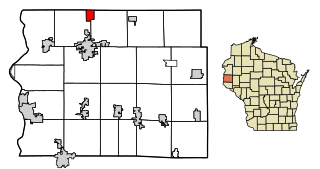
Prairie Farm is a village in Barron County in the U.S. state of Wisconsin. The population was 473 at the 2010 census. The village is located within the Town of Prairie Farm, on eastern shore of the Prairie Farm Flowage, a reservoir on the Hay River.
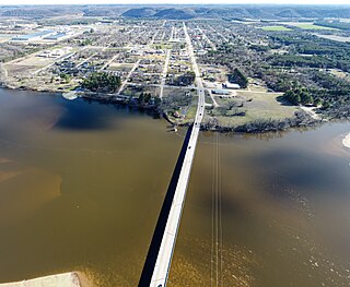
Muscoda is a village in Grant and Iowa counties in the U.S. state of Wisconsin. The population was 1,299 at the 2010 census. Of this, 1,249 were in Grant County and 50 were in Iowa County. The Grant County part of the village is adjacent to the Town of Muscoda and the Iowa County part is adjacent to the Town of Pulaski.

The Town of Prairie du Sac is located in southwestern Sauk County, Wisconsin, United States. The population was 1,138 at the 2000 census. The Village of Prairie du Sac is located within the town. The unincorporated community of Loddes Mill is also located in the town.
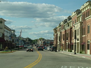
Prairie du Sac is a village in Sauk County, Wisconsin, United States, located along the Wisconsin River. The population was 4,420 at the 2020 census. The village is surrounded by the Town of Prairie du Sac, the Wisconsin River, and the village of Sauk City; together, Prairie du Sac and Sauk City are referred to as Sauk Prairie.
Star Prairie is a village in St. Croix County in the U.S. state of Wisconsin. The population was 561 at the 2010 census. The village is located along the Apple River on the boundary between the Town of Star Prairie and the Town of Stanton.

