Transportation in South Korea is provided by extensive networks of railways, highways, bus routes, ferry services and air routes that traverse the country. South Korea is the third country in the world to operate a maglev train, which is an automatically run people mover at Incheon International Airport.

Incheon, formerly Jemulpo or Chemulp'o (제물포) until the period after 1910, officially the Incheon Metropolitan City, is a city located in northwestern South Korea, bordering Seoul and Gyeonggi to the east. Inhabited since the Neolithic, Incheon was home to just 4,700 people when it became an international port in 1883. Today, about 3 million people live in the city, making it South Korea's third-most-populous city after Seoul and Busan.

The Seoul Metropolitan Subway is a metropolitan railway system consisting of 23 rapid transit, light metro, commuter rail and people mover lines located in northwest South Korea. The system serves most of the Seoul Metropolitan Area including the Incheon metropolis and satellite cities in Gyeonggi province. Some regional lines in the network stretch out beyond the Seoul Metropolitan Area to rural areas in northern Chungnam province and western Gangwon province, that lie over 100 km (62 mi) away from the capital.

Yongin is a city in the Seoul Capital Area, the largest in Gyeonggi Province, South Korea. With a population over 1 million, the city has developed rapidly since the 21st century, recording the highest population growth of any city in the country. Yongin is home to Everland and Caribbean Bay, South Korea's most popular amusement and water parks. The city is also home to the Korean Folk Village, the largest of its kind. Yongin-si is a multi-nuclear city with multiple urban centers, not a single nuclear structure, and Giheung-gu crosses the Yeongdong Expressway and Dongbaek, while Suji-gu crosses Pungdeokcheon Stream and Jukjeon.

Bucheon is a city in Gyeonggi Province, South Korea. Bucheon is located 25 kilometers (16 mi) away from Seoul, of which it is a satellite city. It is located between Incheon and Seoul.
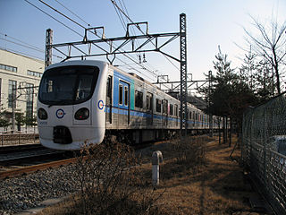
The Incheon Subway is a subway system serving the South Korean city of Incheon. The system is operated by Incheon Transit Corporation, and is part of the greater Seoul Metropolitan Subway.
Incheon Subway Line 1 is a 29.4-kilometer (18.3 mi) north-south subway line, part of the Incheon Subway system. The line is also included as a part of the overall Seoul Metropolitan Subway network; Bupyeong Station has a free transfer with Seoul Subway Line 1, Gyeyang Station connects with the AREX Line which leads to Incheon International Airport and Seoul Station, Bupyeong-gu Office Station has a free transfer with Seoul Subway Line 7, and Woninjae Station has a free transfer with the Suin-Bundang Line.

T-money is a rechargeable series of smart cards and other "smart" devices used for paying transportation fares in and around Seoul and other areas of South Korea. T-money can also be used in lieu of cash or credit cards in some convenience stores and other businesses. The T-money System has been implemented and is being operated by T-money Co., Ltd of which 34.4% owned by Seoul Special City Government, 31.85% owned by LG CNS, and 15.73% owned by Credit Card Union.
Bundang-gu is the largest and most populous district (gu) of Seongnam, a major city in the Seoul Capital Area, South Korea. Bundang-gu is one of South Korea's wealthiest and highest developed areas, being the nation's first and largest completely artificial city built in the early 1990s. Many high-rise luxury condos moved in the early 2000s, with a second planned city built in the late 2000s called Pangyo in the same district. Apartment prices are the second highest in Gyeonggi-do after Gwacheon and 7th highest nationwide, higher than many central Seoul districts such as Mapo-gu or Jongno-gu. Apartments around Pangyo station and the high-rise luxury condos around Jeongja station and Sunae station rival prices in the most expensive areas in the country. Unlike older cities such as Seoul, Bundang has no telephone poles overground, resulting in a clean cityscape with well-designed streets.

Yeongdeungpo District is an administrative district in southwest Seoul, South Korea. Although the origin of the name is uncertain, the first two syllables are thought to be from "yeongdeung" (靈登) or "divine ascent", a shamanic rite. The third syllable is "po", representing the bank of a river (浦), referring to the district's position on the Han River. The 2006 population was 408,819.

Gwanak District (Gwanak-gu) is an administrative subdivision (gu) of Seoul, South Korea. It lies on the southern skirt of Seoul, bordering Anyang of Gyeonggi Province. The southern border of Gwanak-gu, bordering Anyang, consists of the craggy ridgeline of Gwanaksan, which dominates the local geography.

Upass is a prepaid card for the transportation system in Seoul and its suburbs. This card is issued by Seoul Bus Transport Association and eB Card. Its parent-generation card is Seoul Transportation Card, a world-first commercial-used RF card for transportation ¹. The Korean system integrator Intec and Seoul Bus Union first launched a test of their system in a trial from October to December 1995. Old Seoul Transportation Card and T-money can be used along with Upass.
Seoul, the capital and largest city in South Korea, accounts for only 0.6% of the country's total land area, yet it is home to around 19% of the population. The population density in Seoul demands a great deal of the city's transportation systems, which are regarded by many as among the best and most advanced in the world. Seoul is very well connected by its subway and bus systems, and the city is also very supportive of pedestrian foot travel. In 2006 it won the Sustainable Transport Award.
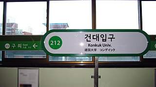
Konkuk University Station is a rapid transit station on Seoul Subway Line 2 and Seoul Subway Line 7. It is located in Hwayang-dong in the Gwangjin-gu administrative district of Seoul. It is adjacent to Konkuk University from which it takes its name. Line 2 is serviced by an elevated platform while Line 7 is serviced by an underground platform. The station has connections to ten bus lines through its six exits as well as a connection to the airport shuttle bus. The station services Hwayang-dong as well as Jayang-dong and Noyu-dong. The area around the station is mixed residential and small commercial businesses. Exits from the underground Line 7 platform open into Konkuk University and the adjacent Star City shopping and high-rise residential tower complex.
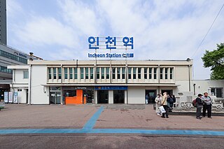
Incheon Station is the western terminus railway station of the Suin–Bundang and Gyeongin Lines of the Seoul Metropolitan Subway. The station is located in the Bukseong neighborhood of the Jung District in Incheon, South Korea and is approximately 20 kilometers west of Seoul. Established in 1899 under the Korean Empire as Chemulpo Station, Incheon Station is the oldest train station in the Seoul Capital Area. During the Japanese occupation of Korea, the station was briefly named Hainchon Station and the original station building was destroyed during the Korean War. Service for the Suin Line began in 1937 and ended in 1995. Service for the Gyeongjin Line began in 1974 and service on the Suin–Bundang Line began in 2020.

Bupyeong District (Bupyeong-gu) is one of the 10 administrative divisions that comprise Incheon, South Korea. Bupyeong-gu comprises an area of 12.35 square miles, and has a population of 508,587. It is located north of Namdong-gu, east of Seo-gu, and south of Gyeyang-gu. The city of Bucheon, in neighboring Gyeonggi Province, comprises its eastern limit.

Incheon Subway Line 2 is a 27 station subway line 29.2-kilometer (18.1 mi) from Oryu-dong in Seo-gu to Incheon Grand Park., part of the Incheon Subway system. The line is also included as a part of the overall Seoul Metropolitan Subway network; Juan station has a free transfer with Seoul Subway Line 1, Geomam station connects with the AREX Line to Incheon International Airport and Seoul Station, and Seongnam also has a free transfer with Seoul Subway Line 7.

Samseong-Dong is an affluent neighborhood or ward of Gangnam-gu in Seoul, South Korea.

Suji-gu, or Suji, is one of the three city districts in Yongin City, South Korea which is approximately 29 km south of Seoul. Suji became a city district on October 31, 2005, about nine years after Yongin officially became a city. When Yongin City was established in 1996, both urban and rural areas were covered to become a part of the city; thus to this day, Yongin's urbanization is varied throughout different regions of the city. Suji is one of the most urbanized areas of Yongin, as it borders Seongnam City's Bundang District and Suwon City, two more well developed areas. Home to the newly built Shinsegae Department Store and Dankook University in one of its towns, Jukjeon, Suji is rapidly developing as Yongin City becomes more and more urbanized. In recent years, the district has attracted upper-class Koreans, with the completion of the Samsung East Palace in 2010.

Wongok-dong is neighbourhood of Danwon-gu, Ansan, Gyeonggi Province, South Korea. It is officially divided into Wongok-1-dong, Wongok-2-dong and Wongok-bondong. The multi cultural special zone (town) is located in wongok-dong. In multi culture town 70% of the people are foreign and 30% of the people are Korean. Wongok-dong has the widest forest area of 34km. The farmland is 18.8km, which is small compared to the total area.


