Seruyan Regency

Last updated
Seruyan Regency
Kabupaten Seruyan
Seruyan.jpg
Sembuluh Lake.jpg
Bundaran Tameng Seruyan.jpg
Betang House Seruyan.jpg
Seruyan River.jpg
Sungai Bakau.jpg
Nurul Yaqin Mosque.jpg
Lambang Kabupaten Seruyan.png
Motto(s): 
"Gawi Hatantiring"
Ngaju language: "Cooperative teamwork"
Lokasi Kalimantan Tengah Kabupaten Seruyan.svg
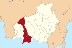
Location within Central Kalimantan
Indonesia Kalimantan location map.svg
Red pog.svg
Seruyan Regency
Location in Kalimantan and Indonesia
Indonesia location map.svg
Red pog.svg
Seruyan Regency
Seruyan Regency (Indonesia)
Coordinates: 2°20′00″S112°15′00″E / 2.3333°S 112.2500°E / -2.3333; 112.2500
Country Indonesia
Region Kalimantan
Province Central Kalimantan
Capital Kuala Pembuang
Government
  Regent Ahmad Selanorwanda  [ id ]
  Vice Regent Supian  [ id ]
Area
  Total
16,404 km2 (6,334 sq mi)
Population
 (mid 2024 estimate)
  Total
174,310
  Density10.626/km2 (27.521/sq mi)
  [1]
Time zone UTC+7 (Western Indonesia Time)
Area code (+62) 519
Website seruyankab.go.id

Seruyan Regency (Indonesian : Kabupaten Seruyan) is one of the thirteen regencies which comprise the Central Kalimantan Province on the island of Kalimantan (Borneo), Indonesia. It was created on 10 April 2002 from what were previously the western districts of East Kotawaringin Regency, and covers a land area of 16,404 km2. The town of Kuala Pembuang in Seruyan Hilir District is the capital of Seruyan Regency. The population of the Regency was 139,931 at the 2010 Census [2] and 162,906 at the 2020 census; [3] the official estimate was at mid 2024 was 174,310 (comprising 92,050 males and 82,270 females). [1]

Contents

History

Administrative districts

At the 2010 Census, Seruyan Regency consisted of five districts (kecamatan), but subsequently each of these districts was split in two. The consequent ten districts are tabulated below with their areas and population totals from the 2010 Census [2] and the 2020 Census, [3] together with the official estimate as at mid 2024. [1] The table also includes the locations of the district administrative centres, the number of administrative villages in each district (a total of 97 rural desa and 3 urban kelurahan), and its postal codes.

Kode
Wilayah
Name of
District
(kecamatan)
Area
in
km2
Pop'n
Census
2010
Pop'n
Census
2020
Pop'on
Estimate
mid 2024
Admin
Centre
No.
of
villages
Post
codes
62.07.01Seruyan Hilir [4]
(Lower Seruyan)
4,659.0036,24637,38240,540Kuala Pembuang10 (a)74213
-74215
62.07.06Seruyan Hilir Timur [5]
(East Lower Seruyan)
1,428.00(b)9,19310,530Pematang Panjang674215
62.07.03Danau Sembuluh [6]
(Lake Sembuluh)
1,555.0029,33513,59615,390Telaga Pulang874261
62.07.07Seruyan Raya [7]
(Great Seruyan)
869.00(b)19,34419,950Terawan574260
62.07.04Hanau [8] 549.0034,95120,83422,190Pembuang Hulu774270
62.07.08Danau Seluluk [9] 586.00(b)17,55618,440Asam Baru674271
62.07.02Seruyan Tengah [10]
(Central Seruyan)
1,343.3227,42223,71925,320Rantau Pulut20 (c)74280
62.07.09Batu Ampar [11] 668.68(b)9,4249,830Sandul974281
62.07.05Seruyan Hulu [12]
(Upper Seruyan)
3,262.0011,9779,1559,350Tumbang Manjul2074291
62.07.10Suling Tambun [13] 1,484.00(b)2,7032,790Tumbang Langkai974290
Totals16,404.00139.931162,906174,310Kuala Pembuang100

Note: (a) including 2 kelurahan - Kuala Pembuang I and Kuala Pembuang II. (b) the 2010 population of this new District is included in the figure for the district immediately preceding it in the table. (c) including one kelurahan - Rantau Pulut.

Transports

The regency is served by the Seruyan Kuala Pembuang Airport ( IATA : KLP).

References

  1. 1 2 3 Badan Pusat Statistik, Jakarta, 28 February 2025, Kabupaten Seruyan Dalam Angka 2025 (Katalog-BPS 1102002.6208)
  2. 1 2 Biro Pusat Statistik, Jakarta, 2011.
  3. 1 2 Badan Pusat Statistik, Jakarta, 2021.
  4. Badan Pusat Statistik, Jakarta, 26 September 2024, Kecamatan Seruyan Hilir Dalam Angka 2024 (Katalog-BPS 1102001.6208010)
  5. Badan Pusat Statistik, Jakarta, 26 September 2024, Kecamatan Seruyan Hilir Timur Dalam Angka 2024 (Katalog-BPS 1102001.6208011)
  6. Badan Pusat Statistik, Jakarta, 26 September 2024, Kecamatan Danau Sembuluh Dalam Angka 2024 (Katalog-BPS 1102001.6208020)
  7. Badan Pusat Statistik, Jakarta, 26 September 2024, Kecamatan Seruyan Raya Dalam Angka 2024 (Katalog-BPS 1102001.6208021)
  8. Badan Pusat Statistik, Jakarta, 26 September 2024, Kecamatan Hanau Dalam Angka 2024 (Katalog-BPS 1102001.6208030)
  9. Badan Pusat Statistik, Jakarta, 26 September 2024, Kecamatan Danau Seluluk Dalam Angka 2024 (Katalog-BPS 1102001.6208031)
  10. Badan Pusat Statistik, Jakarta, 26 September 2024, Kecamatan Seruyan Tengah Dalam Angka 2024 (Katalog-BPS 1102001.6208040)
  11. Badan Pusat Statistik, Jakarta, 26 September 2024, Kecamatan Batu Ampar Dalam Angka 2024 (Katalog-BPS 1102001.6208041)
  12. Badan Pusat Statistik, Jakarta, 26 September 2024, Kecamatan Seruyan Hulu Dalam Angka 2024 (Katalog-BPS 1102001.6208050)
  13. Badan Pusat Statistik, Jakarta, 26 September 2024, Kecamatan Suling Tambun Dalam Angka 2024 (Katalog-BPS 1102001.6208051)

2°20′00″S112°15′00″E / 2.3333°S 112.2500°E / -2.3333; 112.2500