Sukamara Regency

Last updated
Sukamara Regency
Kabupaten Sukamara
Lambang Kabupaten Sukamara.png
Lokasi Kalimantan Tengah Kabupaten Sukamara.svg
Location within Central Kalimantan
Indonesia Kalimantan location map.svg
Red pog.svg
Sukamara Regency
Location in Kalimantan and Indonesia
Indonesia location map.svg
Red pog.svg
Sukamara Regency
Sukamara Regency (Indonesia)
Coordinates: 2°37′36″S111°14′12″E / 2.6267°S 111.2368°E / -2.6267; 111.2368
Country Indonesia
Region Kalimantan
Province Central Kalimantan
Capital Sukamara
Government
  RegentAhmad Dirman
  Vice RegentWindu Subagio
Area
  Total1,478 sq mi (3,827 km2)
Population
 (mid 2022 estimate)
  Total66,845
  Density45/sq mi (17/km2)
  [1]
Time zone UTC+7 (Western Indonesia Time)
Area code (+62) 532
Website sukamarakab.go.id

Sukamara Regency (Indonesian : Kabupaten Sukamara) is one of the thirteen regencies which comprise the Central Kalimantan Province on the island of Kalimantan (Borneo), Indonesia. It was created on 10 April 2002 from the former southwest part of West Kotawaringin Regency. The town of Sukamara is the capital of Sukamara Regency, which covers an area of 3,827 km2. The population of the Regency was 44,952 at the 2010 Census [2] and 63,464 at the 2020 Census; [3] the official estimate as at mid 2022 was 66,845 (comprising 35,122 males and 31,723 females). [1]

Contents

Administrative Districts

Sukamara Regency consists of five districts (kecamatan), tabulated below with their areas and populations from the 2010 Census [2] and the 2020 Census, [3] together with the official estimates as at mid 2022. [1] The table also includes the locations of the district administrative centres, the number of administrative villages in each district (a total of 29 rural desa and 3 urban kelurahan), and its postal codes.
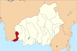
Kode
Wilayah
Name of
District
(kecamatan)
Area
in
km2
Pop'n
Census
2010
Pop'n
Census
2020
Pop'n
Estimate
mid 2022
Admin
centre
No.
of
villages
Post
codes
62.08.02Jelai (a)7964,4125,5205,690Kuala Jelai5 (b)74171
62.08.04Pantai Lunci8044,8465,8606,070Sungai Cabang Barat474170
62.08.01Sukamara1,02819,62630,89032,410Padang8 (c)74172
62.08.03Balai Riam5396,64910,62011,350Balai Riam874173
62.08.05Permata Kecubung6609,92210,56011,320Ajang774174
Totals3,82744,95263,46466,845Sukamara32

Note: (a) Jelai District includes four small offshore islands - Pulau Jamban, Pulau Nibung Hilir, Pulau Nibung Hulu and Pulau Tangguk.
(b) includes one kelurahan - the town of Kuala Jelai. (c) includes 2 kelurahan - Mendawai and Padang.

.

Demographics

Religion as of the Indonesian census of 2010: [4]

Climate

Sukamara has a tropical rainforest climate (Af) with heavy rainfall year-round.

Climate data for Sukamara
MonthJanFebMarAprMayJunJulAugSepOctNovDecYear
Mean daily maximum °C (°F)29.7
(85.5)
29.9
(85.8)
30.4
(86.7)
31.0
(87.8)
31.3
(88.3)
31.1
(88.0)
31.5
(88.7)
31.8
(89.2)
31.9
(89.4)
31.6
(88.9)
30.9
(87.6)
30.1
(86.2)
30.9
(87.7)
Daily mean °C (°F)26.2
(79.2)
26.3
(79.3)
26.6
(79.9)
26.9
(80.4)
27.2
(81.0)
26.9
(80.4)
27.0
(80.6)
27.1
(80.8)
27.2
(81.0)
27.0
(80.6)
26.8
(80.2)
26.3
(79.3)
26.8
(80.2)
Mean daily minimum °C (°F)22.7
(72.9)
22.8
(73.0)
22.8
(73.0)
22.9
(73.2)
23.1
(73.6)
22.7
(72.9)
22.5
(72.5)
22.4
(72.3)
22.6
(72.7)
22.5
(72.5)
22.7
(72.9)
22.6
(72.7)
22.7
(72.9)
Average rainfall mm (inches)234
(9.2)
240
(9.4)
294
(11.6)
319
(12.6)
268
(10.6)
234
(9.2)
209
(8.2)
152
(6.0)
230
(9.1)
260
(10.2)
303
(11.9)
310
(12.2)
3,053
(120.2)
Source: Climate-Data.org [5]

Related Research Articles

<span class="mw-page-title-main">Sikka Regency</span> Regency in Lesser Sunda Islands, Indonesia

Sikka is a regency within East Nusa Tenggara province, Indonesia, on the island of Flores. It is bordered to the west by Ende Regency and to the east by East Flores Regency. It covers an area of 1,731.91 km2 and had a population of 300,301 at the 2010 census and 321,953 at the 2020 Census; the official estimate as at mid 2022 was 326,999. The capital is the town of Maumere, which comprises the districts of Alok Barat, Alok and Alok Timur.

<span class="mw-page-title-main">Barito Kuala Regency</span> Regency in South Kalimantan, Indonesia

Barito Kuala Regency is one of the regencies (kabupaten) in the Indonesian province of South Kalimantan, situated in the southwest of the province. The area is 2,996.46 km2, and the population was 276,147 at the 2010 Census and 313,021 at the 2020 Census; the latest official estimate was 321,769. The capital is the town of Marabahan. The Motto of the Regency is "Selidah".

<span class="mw-page-title-main">Tapin Regency</span> Regency in South Kalimantan, Indonesia

Tapin Regency is one of regencies in the Indonesian province of South Kalimantan; the capital is the town of Rantau. The regency's motto is "Ruhui Rahayu", and it is also shared by another Indonesian province East Kalimantan. It covers an area of 2,174.95 km2 and had a population of 167,877 at the 2010 Census and 189,475 at the 2020 Census; the official estimate as at mid 2022 was 194,628. The administrative centre of the regency is at Rantau.

<span class="mw-page-title-main">North Bengkulu Regency</span> Regency in Bengkulu, Indonesia

North Bengkulu is a regency of Bengkulu Province, Indonesia, on the island of Sumatra. It originally covered much of the northern part of Bengkulu Province, but on 25 February 2003 the most northwesterly districts were split off to form a separate Mukomuko Regency, and on 24 June 2008 the most southeastern districts were likewise split off to create a new Central Bengkulu Regency. The residual regency now covers an area of 4,424.59 km2, and it had a population of 257,675 at the 2010 Census and 296,523 at the 2020 Census; the official estimate as at mid 2022 was 302,833. The administrative centre is at the town of Arga Makmur.

<span class="mw-page-title-main">West Kutai Regency</span> Regency in Kalimantan, Indonesia

West Kutai Regency is a regency (kabupaten) in the Indonesian province of East Kalimantan. It previously covered a much greater area, with a population of 165,091 at the 2010 Census, but in December 2012 the five northernmost districts were split off to form a new Mahakam Ulu Regency; the residual area of 20,384.6 km2 had a population of 140,097 at the 2010 Census, and 165,938 at the 2020 Census; the official estimate as at mid 2022 was 172,288. The town of Sendawar is the administrative capital.

<span class="mw-page-title-main">East Kutai Regency</span> Regency in East Kalimantan, Indonesia

East Kutai Regency is a regency of East Kalimantan province, Indonesia. It has an area of 35,747.50 km2 and had a population of 253,904 at the 2010 census and 434,459 at the 2020 census; the official estimate as at mid 2022 was 425,613. The town of Sangatta is the capital of the regency.

<span class="mw-page-title-main">West Bangka Regency</span> Regency in Bangka Belitung Islands, Indonesia

West Bangka Regency is a regency (kabupaten) of Bangka Belitung Islands Province, Indonesia. It comprises the northwestern part of Bangka Island, together with a number of small islands off its coast. The regency covers an area of 2,820.61 km2 and had a population of 175,110 at the 2010 Census, rising to 204,612 at the 2020 census; the official estimate as at mid 2022 was 209,791 - comprising 108,102 males and 101,689 females. The town of Muntok is its regency seat.

<span class="mw-page-title-main">Yapen Islands Regency</span> Regency in Papua, Indonesia

Yapen Islands Regency is a regency (kabupaten) in Papua Province of eastern Indonesia. It covers an area of 2,432.49 km2 (939.19 sq mi), and had a population of 82,951 at the 2010 Census and 112,676 at the 2020 Census; the official estimate as at mid 2022 was 116,107. It comprises an archipelago which lies in Cenderawasih Bay off the north coast of Western New Guinea.

<span class="mw-page-title-main">Pinrang Regency</span> Regency in South Sulawesi, Indonesia

Pinrang Regency is one of the twenty-one regencies in South Sulawesi Province of Indonesia. Pinrang town is the administrative capital of Pinrang Regency. The regency covers 1,961.77 km2 and had a population of 351,161 at the 2010 Census and 403,994 at the 2020 Census; the official estimate as at mid 2022 was 411,795.

<span class="mw-page-title-main">Sitaro Islands Regency</span> Regency in North Sulawesi, Indonesia

Sitaro Islands Regency is a regency located off the northern extremity of Sulawesi Island in the southern Sangihe Islands, North Sulawesi Province, Indonesia. The regency was formed under Law Number 15 Year 2007 from 2 January 2007, by separation from the Sangihe Islands Regency of which it had previously formed the southern part. The short form of the name is formed from the those of the three principal islands — Siau, Tagulandang and Biaro.

<span class="mw-page-title-main">Paser Regency</span> Regency in East Kalimantan, Indonesia

Paser Regency is a regency (kabupaten) within East Kalimantan province in Indonesia, it is the southernmost regency of the East Kalimantan province. Its administrative centre is Tana Paser. It covers an area of 7,730 km2, and it had a population of 230,316 at the 2010 Census and 275,452 at the 2020 Census; the official estimate as at mid 2022 was 280,065 . Before 2007, this regency was formerly named Pasir Regency.

<span class="mw-page-title-main">Kapuas Regency</span> Regency in Kalimantan, Indonesia

Kapuas Regency is one of the thirteen regencies which divide Central Kalimantan Province, on the island of Kalimantan, Indonesia. It formerly covered a wider area, but on 10 April 2002 two further regencies were cut out of its western districts, and the residual area is now 14,999 km.2 Its population was 329,646 at the 2010 Census and 410,446 at the 2020 Census; the official estimate as at mid 2022 was 423,210. The administrative centre is the town of Kuala Kapuas near the coast, but the largest town is Selat, which includes 8 of the regency's 15 urban kelurahan, and had 73,900 inhabitants in 2022.

<span class="mw-page-title-main">Katingan Regency</span> Regency in Kalimantan, Indonesia

Katingan Regency is one of the thirteen regencies which comprise the Central Kalimantan Province on the island of Kalimantan (Borneo), Indonesia. It was created on 10 April 2002 from what were previously the eastern districts of East Kotawaringin Regency. The town of Kasongan is the capital of the Regency, which covers an area of 17,500 km2. The population of Katingan Regency was 146,439 at the 2010 Census and 162,222 at the 2020 Census; the official estimate as at mid 2022 was 163,989.

<span class="mw-page-title-main">West Kotawaringin Regency</span> Regency of Indonesia

West Kotawaringin Regency is one of the thirteen regencies which comprise the Central Kalimantan Province on the island of Kalimantan (Borneo), Indonesia. It originally comprised the whole western part of the province, but on 10 April 2002 the most westerly districts were split off to form the new Lamandau Regency and Sukamara Regency. The population of the residual part of West Kotawaringin Regency was 235,803 at the 2010 Census and 270,388 at the 2020 Census; the official estimate as at mid 2022 was 274,935. The town of Pangkalan Bun in Arut Selatan District is the capital of West Kotawaringin Regency. The regency has an area of about 10,759 km2.

<span class="mw-page-title-main">Lamandau Regency</span> Regency in Kalimantan, Indonesia

Lamandau Regency is one of the thirteen regencies which comprise the Central Kalimantan Province on the island of Kalimantan (Borneo), Indonesia. It was created on 10 April 2002 from the former northwest part of West Kotawaringin Regency. The town of Nanga Bulik is the capital of Lamandau Regency, which covers an area of 7,673.56 km2. The population of Lamandau Regency was 63,199 at the 2010 census, and 97,611 at the 2020 census; the official estimate as at mid 2022 was 104,387.

<span class="mw-page-title-main">Pulang Pisau Regency</span> Regency in Kalimantan, Indonesia

Pulang Pisau Regency is one of the thirteen regencies which comprise the Central Kalimantan Province on the island of Kalimantan (Borneo), Indonesia. It was created on 10 April 2002 from what were previously the southwest districts of Kapuas Regency. The town of Pulang Pisau is the capital of Pulang Pisau Regency. The population of Pulang Pisau Regency was 120,062 at the 2010 Census ; and 134,499 at the 2020 Census; the official estimate as at mid 2022 was 136,221.

<span class="mw-page-title-main">Kolaka Regency</span> Regency in Southeast Sulawesi, Indonesia

Kolaka Regency is a regency of Southeast Sulawesi Province, Indonesia. It covers an area of 2,958.69 km2 (1,142.36 sq mi) and had a population of 208,817 at the 2010 Census, rising to 237,587 at the 2020 Census; the official estimate as at mid 2022 was 246,137. The principal town lies at Kolaka.

<span class="mw-page-title-main">South Konawe Regency</span> Regency in Southeast Sulawesi, Indonesia

South Konawe Regency is a regency of Southeast Sulawesi Province, Indonesia. It covers an area of 4,237.74 km2 and had a population of 264,587 at the 2010 Census and of 308,524 at the 2020 Census; the official estimate as at mid 2022 was 317,826 - comprising 162,949 males and 154,877 females. The administrative centre is in the town of Andoolo.

<span class="mw-page-title-main">Tolitoli Regency</span> Regency in Central Sulawesi, Indonesia

Tolitoli Regency is a regency of Central Sulawesi Province of Indonesia. It was previously part of a larger Buol Tolitoli Regency, but this was split into two on 4 October 1999 after rapid decentralization of the Indonesian government. The present Tolitoli Regency covers an area of 3,701.54 km2 and had a population of 211,296 at the 2010 Census and 225,154 at the 2020 Census; the official estimate as at mid 2022 was 228,641, comprising 116,514 male and 112,127 female inhabitants. Its regency seat is located at the town of Tolitoli, which is a port town and where its population is concentrated.

<span class="mw-page-title-main">North Bolaang Mongondow Regency</span> Regency in North Sulawesi, Indonesia

North Bolaang Mongondow Regency is a regency of North Sulawesi Province of Indonesia. It was created on 2 January 2007 by splitting off districts which were previously part of Bolaang Mongondow Regency. The regency covers an area of 1,672.61 km2 and had a population of 70,693 at the 2010 Census and 83,112 at the 2020 Census; the official estimate as at mid 2022 was 84,543. Bitauna is the only official town (kelurahan) in the regency, but the administrative centre is at Boroko.

References

  1. 1 2 3 Badan Pusat Statistik, Jakarta, 2023, Kabupaten Sukamara Dalam Angka 2023 (Katalog-BPS 1102001.6208)
  2. 1 2 Biro Pusat Statistik, Jakarta, 2011.
  3. 1 2 Badan Pusat Statistik, Jakarta, 2021.
  4. "Home". bps.go.id.
  5. "Climate: Sukamara". Climate-Data.org. Retrieved 24 November 2020.

2°37′36″S111°14′12″E / 2.6267°S 111.2368°E / -2.6267; 111.2368