Seven Sisters (Queensland)

Last updated

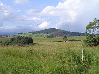
The Seven Sisters are a series of seven volcanic cinder cones on the Atherton Tableland, near Yungaburra, Queensland, Australia. They were formed over 350,000 years ago. [1]

Cinder cone A steep conical hill of loose pyroclastic fragments around a volcanic vent

A cinder cone is a steep conical hill of loose pyroclastic fragments, such as either volcanic clinkers, volcanic ash, or cinder that has been built around a volcanic vent. The pyroclastic fragments are formed by explosive eruptions or lava fountains from a single, typically cylindrical, vent. As the gas-charged lava is blown violently into the air, it breaks into small fragments that solidify and fall as either cinders, clinkers, or scoria around the vent to form a cone that often is symmetrical; with slopes between 30–40°; and a nearly circular ground plan. Most cinder cones have a bowl-shaped crater at the summit.

The Atherton Tableland is a fertile plateau which is part of the Great Dividing Range in Queensland, Australia. The Atherton Tablelands is a diverse region, covering an area of 64,768 square kilometres and home to 45,243 people. The main population centres on the Atherton Tablelands are Mareeba and Atherton. Smaller towns include Tolga, Malanda, Herberton, Kuranda, Ravenshoe, Millaa Millaa, Chillagoe, Dimbulah, Mt Garnet, Mt Molloy, Tinaroo and Yungaburra.

Australia Country in Oceania

Australia, officially the Commonwealth of Australia, is a sovereign country comprising the mainland of the Australian continent, the island of Tasmania, and numerous smaller islands. It is the largest country in Oceania and the world's sixth-largest country by total area. The neighbouring countries are Papua New Guinea, Indonesia, and East Timor to the north; the Solomon Islands and Vanuatu to the north-east; and New Zealand to the south-east. The population of 25 million is highly urbanised and heavily concentrated on the eastern seaboard. Australia's capital is Canberra, and its largest city is Sydney. The country's other major metropolitan areas are Melbourne, Brisbane, Perth, and Adelaide.

Contents

Aerial view of the Seven Sisters, Atherton Tableland, looking to the southwest. Seven Sisters, Atherton Tableland.jpg
Aerial view of the Seven Sisters, Atherton Tableland, looking to the southwest.

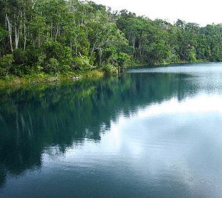
The vents have an overall southwest-northeast alignment, which suggests that the ascending magma utilised a pre-existing fracture within the earth's crust. [2] Several of the craters are breached to the southeast, possibly due to the prevailing southeast winds blowing ash and scoria to the northwest and so building the cones more to that side. Parts of the rocky basalt flows are still densely forested and can be seen surrounding the Curtain Fig Tree.

Scoria Dark vesicular volcanic rock

Scoria is a highly vesicular, dark colored volcanic rock that may or may not contain crystals (phenocrysts). It is typically dark in color, and basaltic or andesitic in composition. Scoria is relatively low in density as a result of its numerous macroscopic ellipsoidal vesicles, but in contrast to pumice, all scoria has a specific gravity greater than 1, and sinks in water. The holes or vesicles form when gases that were dissolved in the magma come out of solution as it erupts, creating bubbles in the molten rock, some of which are frozen in place as the rock cools and solidifies. Scoria may form as part of a lava flow, typically near its surface, or as fragmental ejecta, for instance in Strombolian eruptions that form steep-sided scoria cones. Most scoria is composed of glassy fragments, and may contain phenocrysts. The word scoria comes from the Greek σκωρία, skōria, rust. A colloquial term for scoria is cinder.

Basalt A magnesium- and iron-rich extrusive igneous rock

Basalt is a mafic extrusive igneous rock formed from the rapid cooling of magnesium-rich and iron-rich lava exposed at or very near the surface of a terrestrial planet or a moon. More than 90% of all volcanic rock on Earth is basalt. Basalt lava has a low viscosity, due to its low silica content, resulting in rapid lava flows that can spread over great areas before cooling and solidification. Flood basalt describes the formation in a series of lava basalt flows.

Curtain Fig Tree heritage-listed tree in Queensland, Australia

Curtain Fig Tree is a heritage-listed tree at Curtain Fig Tree Road, Yungaburra, Tablelands Region, Queensland, Australia. It is one of the largest trees in Tropical North Queensland, Australia, and one of the best known attractions on the Atherton Tableland. It was added to the Queensland Heritage Register on 3 December 2009.

See also

Lake Barrine

Lake Barrine is a freshwater lake situated on the eastern parts of Atherton Tableland in the locality of Lake Barrine, Tablelands Region, Far North Queensland, Australia, close to Lake Eacham. The lake and surrounds are protected within the Crater Lakes National Park and are accessible via the Gillies Highway.

Lake Eacham crater lake

Lake Eacham is a popular lake of volcanic origin on the Atherton Tableland of Queensland, Australia, within the World Heritage listed Wet Tropics of Queensland.

The Mount Hypipamee Crater, also known as The Crater is a huge diatreme located south-east of Herberton on the Atherton Tableland in Far North Queensland, Australia. It is 61 metres in diameter and 82 metres deep.

Related Research Articles

Yungaburra Town in Queensland, Australia

Yungaburra is a town located on the Atherton Tableland in Far North Queensland, Australia, not far from Cairns. In the 2011 census, Yungaburra had a population of 1,116 people.

Mount Thielsen mountain

Mount Thielsen, or Big Cowhorn, is an extinct shield volcano in the Oregon High Cascades, near Mount Bailey. Because eruptive activity ceased 250,000 years ago, glaciers have heavily eroded the volcano's structure, creating precipitous slopes and a horn-like peak. The spire-like shape of Thielsen attracts lightning strikes and creates fulgurite, an unusual mineral. The prominent horn forms a centerpiece for the Mount Thielsen Wilderness, a reserve for recreational activities such as skiing and hiking.

São Miguel Island Island in Azores, Portugal

São Miguel Island, nicknamed "The Green Island", is the largest and most populous island in the Portuguese archipelago of the Azores. The island covers 760 km2 (290 sq mi) and has around 140,000 inhabitants, with 45,000 people residing in Ponta Delgada, the archipelago's largest city.

Mount Washington (Oregon) volcano in Oregon, United States

Mount Washington is a deeply eroded volcano in the Cascade Range of Oregon. It lies within Deschutes and Linn counties and is surrounded by the Mount Washington Wilderness area.

Belknap Crater mountain

Belknap Crater is a shield volcano in the Cascade Range in the U.S. state of Oregon. Located in Linn County, it is associated with lava fields and numerous subfeatures including the Little Belknap and South Belknap volcanic cones. It lies north of McKenzie Pass and forms part of the Mount Washington Wilderness. Belknap is not forested and most of its lava flows are not vegetated, though there is some wildlife in the area around the volcano, as well as a number of tree molds formed by its eruptive activity.

Acraman crater impact crater

Acraman crater is a deeply eroded impact crater in the Gawler Ranges of South Australia. Its location is marked by Lake Acraman, a circular ephemeral playa lake about 20 kilometres (12 mi) in diameter. The discovery of the crater and independent discovery of its ejecta were first reported in the journal Science in 1986. The evidence for impact includes the presence of shatter cones and shocked quartz in shattered bedrock on islands within Lake Acraman.

Broken Top mountain

Broken Top is a glacially eroded complex stratovolcano. It lies in the Cascade Volcanic Arc, part of the extensive Cascade Range in the U.S. state of Oregon. Located southeast of the Three Sisters peaks, the volcano, residing within the Three Sisters Wilderness, is 20 miles (32 km) west of Bend, Oregon in Deschutes County. Eruptive activity stopped roughly 100,000 years ago, and currently, erosion by glaciers has reduced the volcano's cone to where its contents are exposed. There are two named glaciers on the peak, Bend and Crook Glacier.

Mount Quincan mountain in Australia

Mount Quincan is a volcanic mountain near Yungaburra on the Atherton Tableland in Far North Queensland, Australia.

Shire of Eacham Local government area in Queensland, Australia

The Shire of Eacham was a local government area of Queensland. It was located on the Atherton Tableland, a plateau forming part of the Great Dividing Range west of the city of Cairns. The shire, administered from the town of Malanda, covered an area of 1,126.4 square kilometres (434.9 sq mi), and existed as a local government entity from 1910 until 2008, when it amalgamated with several other councils in the Tableland area to become the Tablelands Region.

Shire of Atherton Local government area in Queensland, Australia

The Shire of Atherton was a local government area of Queensland. It was located on the Atherton Tableland, a plateau forming part of the Great Dividing Range west of the city of Cairns. The shire, administered from the town of Atherton, covered an area of 623.1 square kilometres (240.6 sq mi), and existed as a local government entity from 1881 until 2008, when it amalgamated with several other councils in the Tableland area to become the Tablelands Region.

Blue Lake Crater Crater in Oregon, USA

Blue Lake Crater is a maar, or a broad, low-relief volcanic crater, in the U.S. state of Oregon. Located in Jefferson County, it consists of three, overlapping craters, which hold Blue Lake, also known as "the Crater Lake of the Central Oregon Cascades." The drainage basin for Blue Lake has very steep, forested slopes and is mostly part of the explosion crater left by the volcano's eruption. The volcano lies within the Metolius River basin, which supports a wide array of plant life, large and small mammals, and more than 80 bird species. The Metolius River is supported by non-profit conservation organizations, and in 2009, Governor of Oregon Ted Kulongoski signed a bill designating the Metolius River basin as an area of critical concern, preventing large-scale development on the land and protecting its wildlife.

Elysium quadrangle quadrangle on Mars

The Elysium quadrangle is one of a series of 30 quadrangle maps of Mars used by the United States Geological Survey (USGS) Astrogeology Research Program. The Elysium quadrangle is also referred to as MC-15.

Crater Hill

Crater Hill is one of the volcanoes of the Auckland volcanic field. It consists of an explosion crater about 600m wide, partly filled with water.

Lynch's Crater formed about 230,000 years ago during an explosive volcanic eruption, creating a maar on the eastern edge of the Atherton Tableland in Queensland, Australia. Located at an altitude of about 760 m, the crater is about 80 m deep and has been heavily worn by erosion. Following its formation, a crater lake formed in the depression that was gradually filled in with deposits, so that the surface is now an average of 45 m beneath the rim. The present day interior is filled with swampy ground that is maintained by a stream flowing in from the eastern side. This water exits the crater to form a tributary of the North Johnstone River. The mean annual rainfall at this site is 2,500 mm.

Sand Mountain Volcanic Field

The Sand Mountain Volcanic Field is a volcanic field in the upper McKenzie River watershed, located in the United States in Oregon. Part of the Cascade Volcanic Arc, it lies southwest of Mount Jefferson and northwest of Belknap Crater and Mount Washington. Its highest elevation is 5,463 feet (1,665 m).

References

  1. Whitehead, P. W.; Stephenson, P. J.; McDougall, I.; Hopkins, M. S.; Graham, A. W.; Collerson, K. D.; Johnson, D. P. (2007). "Temporal development of the Atherton Basalt Province, north Queensland". Australian Journal of Earth Sciences. 54 (5): 691–709. doi:10.1080/08120090701305236. ISSN   0812-0099.
  2. Rocks, landscapes & resources of the wet tropics. Lottermoser, Bernd G., Willmott, W. F. Brisbane, Qld.: Geological Society of Australia, Queensland Division. 2008. ISBN   9780975789483. OCLC   271828487.CS1 maint: others (link)

Coordinates: 17°16′08″S145°33′29″E / 17.26889°S 145.55806°E / -17.26889; 145.55806

Geographic coordinate system Coordinate system

A geographic coordinate system is a coordinate system that enables every location on Earth to be specified by a set of numbers, letters or symbols. The coordinates are often chosen such that one of the numbers represents a vertical position and two or three of the numbers represent a horizontal position; alternatively, a geographic position may be expressed in a combined three-dimensional Cartesian vector. A common choice of coordinates is latitude, longitude and elevation. To specify a location on a plane requires a map projection.