
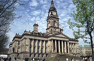
Bolton is a town in Greater Manchester in England. In the foothills of the West Pennine Moors, Bolton is between Manchester, Blackburn, Wigan, Bury and Salford. It is surrounded by several towns and villages that form the wider borough, of which Bolton is the administrative centre. The town is within the historic county boundaries of Lancashire.
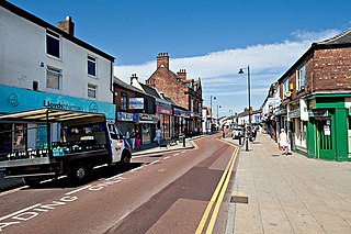
Atherton is a town in the Metropolitan Borough of Wigan in Greater Manchester, England and historically part of Lancashire. The town, including Hindsford, Howe Bridge and Hag Fold, is 5 miles (8.0 km) south of Bolton, 7 miles (11.3 km) east of Wigan, and 10 miles (16.1 km) northwest of Manchester. From the 17th century, for about 300 years, Atherton was known as Chowbent, which was frequently shortened to Bent, the town's old nickname. During the Industrial Revolution, the town was a key part of the Manchester Coalfield.

Belmont is a village and former civil parish, now in the parish of North Turton, in the unitary authority area of Blackburn with Darwen, in the ceremonial county of Lancashire, England. It is close to Darwen and has around 500 inhabitants.

Blackrod is a town and civil parish situated within the Metropolitan Borough of Bolton in Greater Manchester, England. Nestled in the historic County of Lancashire, Blackrod is positioned 3.9 miles (6.3 km) northeast of Wigan and 6.6 miles (10.6 km) west of Bolton. According to the United Kingdom Census of 2021, the town has a population of 5,345.
Turton Urban District was, from 1873 to 1974, a local government district centred on the historical area of Turton in the administrative county of Lancashire, England.

Harwood is a suburb to the north-northeast of Bolton, Greater Manchester, England, bordering Bury. Harwood is also part of the historic county of Lancashire.

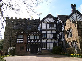
Halliwell is predominantly a residential area of Bolton, Greater Manchester, England. It gives its name to an electoral ward of the wider Metropolitan Borough of Bolton. The population of this ward taken at the 2011 census was 13,929. Halliwell lies about 2 miles (3.2 km) to the north west of Bolton town centre and is bounded by Tonge Moor to the east and Heaton to the south west. Smithills Hall to the north is within the ancient township. It lies on the lower south facing slopes of the West Pennine Moors.

Breightmet is a neighbourhood of Bolton, Greater Manchester, England. The population at the 2011 census was 13,584. Historically a township of the civil and ecclesiastical parish of Bolton le Moors in the Salford hundred of Lancashire, it lies 2 miles (3.2 km) north-east of Bolton and 4 miles (6.4 km) north-west of Bury.
Bolton le Moors was a large civil parish and ecclesiastical parish in hundred of Salford in the historic county of Lancashire, England. It was administered from St Peter's Church, Bolton in the township of Great Bolton.

Turton is a historical area in the North West of England. It is part of the ceremonial counties of Lancashire and Greater Manchester. The Turton area is located north of Bolton and south of Blackburn. The area historically formed a township in the ancient parish of Bolton le Moors. The principal village in the township is now known as Chapeltown.

Heath Charnock is a small village and civil parish of the Borough of Chorley in Lancashire, England. According to the United Kingdom Census 2001 it has a population of 2,065, reducing to 2,026 at the 2011 Census.
Bolton was, from 1838 to 1974, a local government district in the northwest of England conterminate with the town of Bolton.

Tonge is an outlying area of Bolton, in Greater Manchester, England. The name is supposed to be derived from the Old English "tang" or "twang" meaning a fork in a river. Tonge comprises two areas, namely Tonge Fold and Tonge Moor. Tonge Fold sits upon the River Tonge, a region of whose banks are a geological site of special scientific interest (SSSI).

Little Bolton was a township of the civil and ecclesiastical parish of Bolton le Moors in the Salford hundred of Lancashire, England, and later a separate civil parish. Besides the main part of Little Bolton, it had three detached parts which were separated by areas of Lower Sharples and Higher Sharples. Despite its name, Little Bolton had a larger acreage than its southern neighbour Great Bolton, from which it was separated by the River Croal. In 1891 the parish had a population of 44,307.

Tonge with Haulgh was a township of the civil and ecclesiastical parish of Bolton le Moors in the Salford hundred of Lancashire, England, and later a separate civil parish. In 1891 the parish had a population of 10,735.

Quarlton was a township of the civil and ecclesiastical parish of Bolton le Moors in the Hundred of Salford, Lancashire, England. It lay 4+1⁄2 miles (7.2 km) north east of Bolton. In 1891 the parish had a population of 251.

Longworth was a township of the civil and ecclesiastical parish of Bolton le Moors in the Salford hundred of Lancashire, England. In 1891 it had a population of 102.

Smithills is a mainly residential suburb of Bolton in Greater Manchester, England. It is 3.1 miles (5 km) northwest of Bolton, 14.5 miles (23 km) south of Blackburn and 11.9 miles (19 km) northwest of Manchester. Smithills lies on the lower south facing slopes of the West Pennine Moors.
Astley Bridge is predominantly a residential district of Bolton in Greater Manchester, England. It is 2.5 miles (4 km) north of Bolton town centre, 11.7 miles (19 km) south of Blackburn, and 14.3 miles (23 km) northwest of Manchester.

