Sheeri, Baramulla

Last updated

Sheeri
Village Representation.
Kashmir region. LOC 2003626427 - showing Kashmir division administered by India in neon blue.jpg
Sheeri lies in Baramulla, which lies in the Kashmir division (neon blue) of the Indian-administered Jammu and Kashmir (shaded tan) in the disputed Kashmir region. [1]
Coordinates: 34°11′01″N74°18′35″E / 34.18361°N 74.30972°E / 34.18361; 74.30972
Administering country India
Languages
  Official Kashmiri, Urdu, English
Time zone UTC+5:30 (IST)
PIN
193103, 193101 (Baramulla City)
Telephone code +9101952
Vehicle registration JK-05
Website thevarmul.wixstudio.io/varmul

Sheeri is a village located in Baramulla district of Jammu and Kashmir, India. The village has two adjoining areas namely "Sheeri Bala" and "Sheeri Payeen". [2] It is located 10 km towards the west of the district headquarters Baramulla and 52 km from the state capital Srinagar. Sheeri is surrounded by Singhpora Tehsil to the east, Rohama Tehsil to the north, Kralpora Tehsil to the south and Boniyar Tehsil to the west. [3]

If examined demographically, it's a beautiful place—a passage of the Jehlum, surrounded by mountains, forming the historic road that links the western world from its view to The Gateway of Kashmir. If put in simple words, this place can be called "The Primary Gate of The Gateway of Kashmir". [1]

It begins from a curve following the "Batt Colony", the curve is known as "Dana Ka Moad" i.e., The Curve of Brilliance. Soon enough your eyes glide over the Jehlum to the mountains ahead that separate the Narvaw area from the other world.

One of the notable places is the Eco Park surrounded by Jehlum like an island.

The Sheeri Market is a pretty small but sufficient market. People from all over the neighbouring localities indulge in this market. If it was under serious management, it could have developed significantly.

There are vast orchids mostly, apples and fields of paddy in Sheeri. Walter Roper Lawrence, in his book "Valley of Kashmir", has talked about this place and is believed to have travelled here and researched much.

To the south of this village lie a conjunction of villages and beauties, which are part of the Narvaw area. This area also includes mountains leading to southeastern villages like Heewan and Kalyan, which ultimately lead to Gulmarg. From the mid southern part lie villages like Fatehgarh (Historic Landmark), Malpora and Dangerpira which will also lead the traveller to Gulmarg and other fantasies. On the south-western side lie villages like Zogiyar, Zandfarn and Badmulla which subsequently track towards one of the Kashmir's Beautiful but unpopular Places called "Goas". That place is a Dream.

The western part of Sheeri is paved on the banks of Jehlum and the national highway, leading to Gantamulla (I Call it the British Project) then to Uri after a long trip.

Related Research Articles

<span class="mw-page-title-main">Srinagar district</span> District of Jammu and Kashmir, India

The Srinagar District is an administrative district of Indian-administered Jammu and Kashmir in the disputed Kashmir region. It is one of the 20 districts of Jammu and Kashmir. Situated in the centre of the Kashmir Valley, it is the second-most populous district of the union territory after Jammu District as per the 2011 national census, and is home to the summer capital city of Srinagar. Likewise, the city of Srinagar also serves as the Srinagar District's headquarters.

<span class="mw-page-title-main">Muzaffarabad</span> Capital of Azad Kashmir, a region administered by Pakistan

Muzaffarabad is a city in Pakistani-administered Azad Kashmir in the disputed Kashmir region. It is the largest city and the capital of Azad Kashmir, which is a Pakistani-administered administrative territory.

<span class="mw-page-title-main">Baramulla district</span> District in Jammu and kashmir, India

Baramulla district or Varmul is one of the 20 districts in the Indian-administered union territory of Jammu and Kashmir in the disputed Kashmir region. Baramulla town is the administrative headquarters of this district. The district covered an area of 4,588 km2 (1,771 sq mi) in 2001, but it was reduced to 4,243 km2 (1,638 sq mi) at the time of 2011 census. In 2016, the district administration said that the area was 4,190 km2 (1,620 sq mi). Muslims constitute about 98% of the population.

<span class="mw-page-title-main">Bagh District</span> District of Azad Kashmir administered by Pakistan

Bagh District is a district of Pakistan-administered Azad Kashmir in the disputed Kashmir region. It is one of the ten districts of Azad Jammu and Kashmir. Previously part of Poonch District, Bagh was established as a separate district in 1988.

<span class="mw-page-title-main">Bhimber District</span> District in Azad Jammu and Kashmir, Pakistan

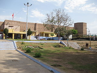
Bhimber District is a district of Pakistan-administered Azad Kashmir in the disputed Kashmir region. It is the southernmost of the 10 districts of Pakistan's territory of Azad Kashmir. It has an area of 1,516 km², and the district headquarter is the town of Bhimber.

<span class="mw-page-title-main">Kotli District</span> District in Azad Kashmir, Pakistan

Kotli District is a district of Pakistan-administered Azad Kashmir in the Azad Kashmir region. It is one of the 10 districts of Pakistan's dependent territory of Azad Kashmir. It is bounded on the north by the Sudhanoti District and the Poonch District, on the north-east by the Poonch District of Indian-administered Jammu and Kashmir, on the south by the Mirpur and Bhimber districts, and on the west by the Rawalpindi District on Pakistan's Punjab Province. Kotli is the biggest district of Azad Kashmir by population and the second biggest by land area, after the Neelum District. The district headquarters is the city of Kotli. The main native languages are Pahari, and Gujari.

<span class="mw-page-title-main">Muzaffarabad District</span> District of Azad Kashmir administered by Pakistan

The Muzaffarabad District is a district of Pakistan-administered Azad Kashmir in the disputed Kashmir region. It is one of the 10 districts of this dependent territory. The district is located on the banks of the Jhelum and Neelum rivers and is very hilly. The total area of the Muzaffarabad District is 1,642 square kilometres (634 sq mi). The district is part of the Muzaffarabad Division, and the city of Muzaffarabad serves as the capital of Azad Kashmir. The district is bounded on the north-east by the Neelum District and the Kupwara District of Indian-administered Jammu and Kashmir region, on the south-east by the Hattian Bala District, on the south by the Bagh District, and on the west by the Mansehra and Abbottabad districts of Pakistan's Khyber Pakhtunkhwa Province.

<span class="mw-page-title-main">Poonch District, Pakistan</span> District of Azad Kashmir administered by Pakistan

Poonch District is a district of Pakistan-administered Azad Kashmir in the disputed Kashmir region. It is one of the 10 districts of this Pakistan-administered territory. It is bounded on the north by Bagh District, on the north-east by Haveli District, on the south-east by the Poonch District of Indian-administered Kashmir, on the south by Azad Kashmir's Sudhanoti and Kotli districts, and on the west by Rawalpindi District of Pakistan's Punjab Province. The Poonch District is part of the greater Kashmir dispute between India and Pakistan. The district headquarters is the city of Rawalakot. It is the third most populous district of Azad Kashmir.

<span class="mw-page-title-main">Jammu district</span> District of Jammu and Kashmir administered by India

Jammudistrict is an administrative district of the Jammu division of Indian-administered Jammu and Kashmir in the disputed Kashmir region. It is the most populous district in the Jammu division.

<span class="mw-page-title-main">Gilgit District</span> District of Gilgit-Baltistan in Pakistan

The Gilgit District is one of the 14 districts of Pakistan-administered territory of Gilgit-Baltistan in the disputed Kashmir region. The headquarters of the district is the town of Gilgit. At the 1998 census, the Gilgit District had a population of 243,324. The district includes Gilgit, the Bagrot Valley, Juglot, Danyore, Sultanabad, Naltar Peak, and the Nomal Valley. The highest peak in the district is Distaghil Sar 7,885 metres (25,869 ft), which is the seventh-highest peak in Pakistan and 19th highest in the world.

<span class="mw-page-title-main">Kupwara district</span> District of Jammu and Kashmir administered by India

Kupwara district is an administrative district of Indian-administered Jammu and Kashmir in the disputed Kashmir region. It is one of the 10 districts located in the Kashmir Valley Division of Indian administered Kashmir. The Pohru River and Mawar river are two main rivers in the district. Both of them meet Jhelum river in Baramulla district.

<span class="mw-page-title-main">Reasi district</span> District of Jammu and Kashmir administered by India

Reasi district is an administrative district in the Jammu division of Indian-administered Jammu and Kashmir in the disputed Kashmir region. The Reasi district is bordered by Udhampur district and Ramban district in the east, Jammu district in the south, Rajouri district in the west and by Kulgam district on the north. The Reasi and Rajouri tehsils formed a joint district called the "Reasi district" at the time of the princely state's accession to India in 1947. As part of the reorganisation, the two tehsils were separated and Reasi was merged with the Udhampur district. It again became a separate district in 2006.

<span class="mw-page-title-main">Neelum District</span> District of Azad Kashmir, Pakistan

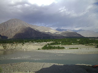
Neelum is a district of Pakistan-administered Azad Kashmir in the disputed Kashmir region. It is the northernmost of 10 districts located within the Pakistani-administered territory of Azad Kashmir. Taking up the larger part of the Neelum Valley, the district had a population of around 191,000 people. It was among the worst-hit areas of Pakistan during the 2005 Kashmir earthquake.

<span class="mw-page-title-main">Bandipore district</span> District of Jammu and Kashmir administered by India

Bandipore district is an administrative district of Indian-administered Jammu and Kashmir in the disputed Kashmir region. It is one of the 20 districts in the Jammu and Kashmir. Bandipore town is the administrative headquarters of the district. Bandipore is located in the foothills of the snow-clad peaks of Harmukh overlooking the shores of Wular Lake and has produced hundreds of scholars and intellectuals. The district is known for its tourist places such as Wular Vintage Park, Athwatoo and Gurez valley. Before 1947, this town was a big trade and literary centre of Kashmir. This district was carved out from the erstwhile Baramulla district in 2007. The district is bounded by Kupwara district from the north, Baramulla district from west and Kargil district in Ladakh and Ganderbal district from the east. This district occupies an area of 398 km2. The district has a population of 392,232 as per 2011 census.

<span class="mw-page-title-main">Haveli District</span> District in Azad Jammu and Kashmir

The Haveli District is a district of Pakistan-administered Azad Kashmir in the disputed Kashmir region. It is one of the 10 districts of the Pakistan-administered territory of Azad Kashmir. It was previously a tehsil of the Bagh District but was promoted to the district status on 1 July 2009.

<span class="mw-page-title-main">Hattian Bala District</span> District of Azad Kashmir, administered by Pakistan

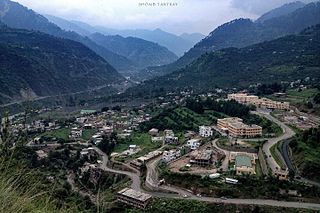
Hattian Bala District is a district of Pakistan-administered Azad Kashmir in the disputed Kashmir region. The town of Hattian Bala is where the district headquarters are located. The Hattian Bala District was a part of the Muzaffarabad District until 2009 when it was made a separate district.

<span class="mw-page-title-main">Kashmir division</span> Administrative division in Indian-administered Jammu and Kashmir

The Kashmir division is a revenue and administrative division of the Indian-administered Jammu and Kashmir in the disputed Kashmir region. It comprises the Kashmir Valley, bordering the Jammu Division to the south and Ladakh to the east. The Line of Control forms its boundary with the Pakistani-administered territories of Gilgit−Baltistan and Azad Jammu and Kashmir to the north and west and west, respectively.

<span class="mw-page-title-main">Gilgit Division</span> Administrative division of Pakistan-administered Gilgit-Baltistan

Gilgit Division is an administrative division of Pakistan-administered Gilgit-Baltistan in the disputed Kashmir region. Gilgit is the divisional headquarters of Gilgit Division. Since divisions were restored as an administrative structure in 2008, the division currently consists of six districts:

<span class="mw-page-title-main">Baltistan Division</span> Administrative division of Pakistan-administered Gilgit-Baltistan

Baltistan Division is a first-order administrative division of Pakistan-administered Gilgit-Baltistan in the disputed Kashmir region. It overlaps with the historical Baltistan region.

<span class="mw-page-title-main">Diamer Division</span> Administrative division of Gilgit-Baltistan, Pakistan

Diamer Division, also known as Diamer-Astore Division, is a first-order administrative division of Gilgit-Baltistan region in Pakistan.

References

  1. 1 2 The application of the term "administered" to the various regions of Kashmir and a mention of the Kashmir dispute is supported by the tertiary sources (a) through (d), reflecting due weight in the coverage. Although "controlled" and "held" are also applied neutrally to the names of the disputants or to the regions administered by them, as evidenced in sources (f) through (h) below, "held" is also considered politicized usage, as is the term "occupied," (see (i) below).
    (a) Kashmir, region Indian subcontinent, Encyclopaedia Britannica, retrieved 15 August 2019 (subscription required) Quote: "Kashmir, region of the northwestern Indian subcontinent ... has been the subject of dispute between India and Pakistan since the partition of the Indian subcontinent in 1947. The northern and western portions are administered by Pakistan and comprise three areas: Azad Kashmir, Gilgit, and Baltistan, the last two being part of a territory called the Northern Areas. Administered by India are the southern and southeastern portions, which constitute the state of Jammu and Kashmir but are slated to be split into two union territories.";
    (b) Pletcher, Kenneth, Aksai Chin, Plateau Region, Asia, Encyclopaedia Britannica, retrieved 16 August 2019 (subscription required) Quote: "Aksai Chin, Chinese (Pinyin) Aksayqin, portion of the Kashmir region, at the northernmost extent of the Indian subcontinent in south-central Asia. It constitutes nearly all the territory of the Chinese-administered sector of Kashmir that is claimed by India to be part of the Ladakh area of Jammu and Kashmir state.";
    (c) "Kashmir", Encyclopedia Americana, Scholastic Library Publishing, 2006, p. 328, ISBN   978-0-7172-0139-6 C. E Bosworth, University of Manchester Quote: "KASHMIR, kash'mer, the northernmost region of the Indian subcontinent, administered partlv by India, partly by Pakistan, and partly by China. The region has been the subject of a bitter dispute between India and Pakistan since they became independent in 1947";
    (d) Osmańczyk, Edmund Jan (2003), Encyclopedia of the United Nations and International Agreements: G to M, Taylor & Francis, pp. 1191–, ISBN   978-0-415-93922-5 Quote: "Jammu and Kashmir: Territory in northwestern India, subject to a dispute betw een India and Pakistan. It has borders with Pakistan and China."
    (e) Talbot, Ian (2016), A History of Modern South Asia: Politics, States, Diasporas, Yale University Press, pp. 28–29, ISBN   978-0-300-19694-8 Quote: "We move from a disputed international border to a dotted line on the map that represents a military border not recognized in international law. The line of control separates the Indian and Pakistani administered areas of the former Princely State of Jammu and Kashmir.";
    (f) Kashmir, region Indian subcontinent, Encyclopaedia Britannica, retrieved 15 August 2019 (subscription required) Quote: "... China became active in the eastern area of Kashmir in the 1950s and has controlled the northeastern part of Ladakh (the easternmost portion of the region) since 1962.";
    (g) Bose, Sumantra (2009), Kashmir: Roots of Conflict, Paths to Peace, Harvard University Press, pp. 294, 291, 293, ISBN   978-0-674-02855-5 Quote: "J&K: Jammu and Kashmir. The former princely state that is the subject of the Kashmir dispute. Besides IJK (Indian-controlled Jammu and Kashmir. The larger and more populous part of the former princely state. It has a population of slightly over 10 million, and comprises three regions: Kashmir Valley, Jammu, and Ladakh.) and AJK ('Azad" (Free) Jammu and Kashmir. The more populous part of Pakistani-controlled J&K, with a population of approximately 2.5 million. AJK has six districts: Muzaffarabad, Mirpur, Bagh, Kodi, Rawalakot, and Poonch. Its capital is the town of Muzaffarabad. AJK has its own institutions, but its political life is heavily controlled by Pakistani authorities, especially the military), it includes the sparsely populated "Northern Areas" of Gilgit and Baltistan, remote mountainous regions which are directly administered, unlike AJK, by the Pakistani central authorities, and some high-altitude uninhabitable tracts under Chinese control."
    (h) Fisher, Michael H. (2018), An Environmental History of India: From Earliest Times to the Twenty-First Century, Cambridge University Press, p. 166, ISBN   978-1-107-11162-2 Quote: "Kashmir’s identity remains hotly disputed with a UN-supervised "Line of Control" still separating Pakistani-held Azad ("Free") Kashmir from Indian-held Kashmir.";
    (i) Snedden, Christopher (2015), Understanding Kashmir and Kashmiris, Oxford University Press, p. 10, ISBN   978-1-84904-621-3 Quote:"Some politicised terms also are used to describe parts of J&K. These terms include the words 'occupied' and 'held'."
  2. "Sheeri School of Baramulla Kashmir". Daily Excelsior. 3 October 2018. Retrieved 5 June 2023.
  3. "A Look into Sheeri_ Sourced by thevarmul".