Crawford County is a county located in the U.S. state of Pennsylvania. As of the 2010 census, the population was 88,765. Its county seat is Meadville. The county was created on March 12, 1800, from part of Allegheny County and named for Colonel William Crawford.
South Shenango Township is a township in Crawford County, Pennsylvania, United States. The population was 2,037 at the 2010 census.

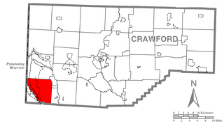
West Shenango Township is a township in Crawford County, Pennsylvania, United States. The population was 504 at the 2010 census.
Shenango Township is a township in Lawrence County, Pennsylvania, United States. The population was 7,479 at the 2010 census. Shenango Township is situated between the city of New Castle to the north and the borough of Ellwood City to the south.

West Middlesex is a borough in Mercer County, Pennsylvania, along the Shenango River. The population was 863 at the 2010 Census. It is part of the Youngstown-Warren-Boardman, OH-PA Metropolitan Statistical Area.
Shenango Township can refer to these places in the U.S. state of Pennsylvania:
Pymatuning State Park is a Pennsylvania state park covering 21,122 acres (8,548 ha) in Conneaut, North Shenango, Pine, Sadsbury, South Shenango, West Fallowfield and West Shenango Townships, Crawford County, Pennsylvania, in the United States. Pymatuning State Park is the largest state park in Pennsylvania and contains the 17,088 acres (6,915 ha) of Pymatuning Lake, three-quarters of which is in Pennsylvania and one-quarter of which is in Ohio. A three-mile (5 km) causeway extends between Pennsylvania and Ohio near the center of the lake. The lake provides fishing and boating year round. There are two natural areas, Clark Island and Blackjack in the park. The park is also home to the University of Pittsburgh's Pymatuning Laboratory of Ecology. Like all Pennsylvania state parks, admission to the Pymatuning State Park is free. The northern access for Pymatuning State Park can be reached from U.S. Route 6 and the southern access is reached from U.S. Route 322.

The Mahoning Valley is a geographic valley encompassing the area of northeast Ohio and northwest Pennsylvania that drains into the Mahoning River. The Mahoning and Shenango rivers empty into the Beaver River, which empties into the Ohio River. The Mahoning River flows through Lawrence County and the Shenango River flows through Mercer County in Pennsylvania, and then the Mahoning River flows from Stark, Mahoning, Trumbull, and Portage counties in Ohio. The three main tributaries of the Mahoning River are Mosquito Creek, West Branch, and Eagle Creek, all in Ohio. It is often referred to by locals as the "Ho".

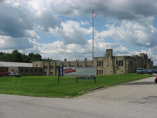
Penn State Shenango is a Commonwealth Campus of the Pennsylvania State University, located on a 14-acre (57,000 m2) campus in downtown Sharon, Pennsylvania. Penn State Shenango has the distinction of being the only urban campus in the Penn State system, although some parts of Penn State Altoona that are located in the heart of Altoona's downtown are urban in nature.

The Shenango River is a principal tributary of the Beaver River, approximately 100 mi (160 km) long, in western Pennsylvania in the United States. It also briefly flows through small portions of northeastern Ohio. Via the Beaver and Ohio Rivers, it is part of the watershed of the Mississippi River.
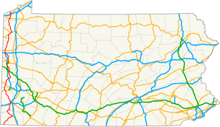
Pennsylvania Route 18 is a major north–south highway in Western Pennsylvania whose southern terminus is at West Virginia Route 69 at the state line in Greene County, Pennsylvania near the village of Garrison, while the northern terminus is at PA Route 5 in Lake City, Pennsylvania. At a length of 205 miles (330 km), PA 18 is the only state route in Pennsylvania — north–south or east–west — to traverse the entire state. It also has the distinction of being the longest state route in Pennsylvania.
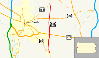
Pennsylvania Route 388 is a north–south state highway in Lawrence County, Pennsylvania, United States, located in Western Pennsylvania. It travels 8.4 miles (13.5 km) between PA 168 in East Brook and PA 65 in Energy.

Pennsylvania Route 318 is a 15.9-mile-long (25.6 km) state highway located in Mercer County, Pennsylvania. The western terminus is at the Ohio state line in Shenango Township near West Middlesex where the road continues as Ohio State Route 304. The eastern terminus is at PA 158 in Mercer.

Pennsylvania Route 718 is an 11.1-mile-long (17.9 km) state highway located in Mercer County, Pennsylvania. The southern terminus is at PA 318 in Shenango Township. The northern terminus is the Ohio state line in South Pymatuning Township.
Synod of the Trinity is an upper judicatory of the Presbyterian Church headquartered in Camp Hill, Pennsylvania. The synod oversees sixteen presbyteries covering all of Pennsylvania, most of West Virginia, and a portion of eastern Ohio.

The Beaver and Erie Canal, also known as the Erie Extension Canal, was part of the Pennsylvania Canal system and consisted of three sections: the Beaver Division, the Shenango Division, and the Conneaut Division. The canal ran 136 miles (219 km) north–south near the western edge of the state from the Ohio River to Lake Erie through Beaver County, Lawrence County, Mercer County, Crawford County, and Erie County, Pennsylvania.

Lawrence County is a county located in the U.S. state of Pennsylvania, United States. As of the 2010 census, the population was 91,108. The county seat is New Castle.
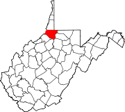
Shenango Creek is a stream in the U.S. state of West Virginia.