
Sanjaks were administrative divisions of the Ottoman Empire. Sanjak, and the variant spellings sandjak, sanjaq and sinjaq, are English or French transliterations of the Turkish word sancak, meaning "district", "banner" or "flag". Sanjaks were also called by the Arabic word for banner or flag: لواء liwa .

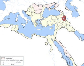
The administrative divisions of the Ottoman Empire were administrative divisions of the state organisation of the Ottoman Empire. Outside this system were various types of vassal and tributary states.
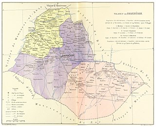
The Vilayet of Diyâr-ı Bekr was a first-level administrative division (vilayet) of the Ottoman Empire, wholly located within what is now modern Turkey. The vilayet extended south from Palu on the Euphrates to Mardin and Nusaybin on the edge of the Mesopotamian plain. After the establishment of Republic of Turkey in 1923, the region was incorporated into the newly created state.
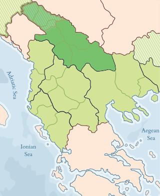
The Vilayet of Kosovo was a first-level administrative division (vilayet) of the Ottoman Empire in the Balkan Peninsula which included the current territory of Kosovo and the north-western part of the Republic of North Macedonia. The areas today comprising Sandžak (Raška) region of Serbia and Montenegro, although de jure under Ottoman control, were in fact under Austro-Hungarian occupation from 1878 until 1909, as provided under Article 25 of the Treaty of Berlin. Üsküb (Skopje) functioned as the capital of the province and the midway point between Istanbul and its European provinces. Üsküb's population of 32,000 made it the largest city in the province, followed by Prizren, also numbering at 30,000.

The Vilayet of Van was a first-level administrative division (vilayet) of the Ottoman Empire. At the beginning of the 20th century, it reportedly had a population of about 400,000 and an area of 15,000 square miles (39,000 km2). Van Vilayet was one of the six Armenian vilayets and held, prior to the Armenian genocide during World War I, possessed a majority Armenian population, as well as Kurdish, Assyrian and Azeri minorities.

The Vilayet of the Danube or Danubian Vilayet was a first-level administrative division (vilayet) of the Ottoman Empire from 1864 to 1878. In the late 19th century it reportedly had an area of 34,120 square miles (88,400 km2).
The Vilayet of Manastir was a first-level administrative division (vilayet) of the Ottoman Empire, created in 1874, dissolved in 1877 and re-established in 1879. The vilayet was occupied during the First Balkan War in 1912 and divided between the Kingdom of Greece and the Kingdom of Serbia, with some parts later becoming part of the newly established Principality of Albania.
The Vilayet of Scutari, Shkodër or Shkodra was a first-level administrative division (vilayet) of the Ottoman Empire that existed from 1867 to 1913, located in parts of what today is Montenegro and Albania. In the late 19th century it reportedly had an area of 13,800 square kilometres.

Eğri Eyalet or Pashaluk of Eğri was an administrative territorial entity of the Ottoman Empire formed in 1596 with its capital at Eğri. It included parts of present-day Hungary and Slovakia.
The demographics of the Ottoman Empire include population density, ethnicity, education level, religious affiliations and other aspects of the population.

The Eyalet of Bosnia, was an eyalet of the Ottoman Empire, mostly based on the territory of the present-day state of Bosnia and Herzegovina. Prior to the Great Turkish War, it had also included most of Slavonia, Lika, and Dalmatia in present-day Croatia. Its reported area in 1853 was 52,530 square kilometres (20,281 sq mi).
The Erzurum Eyalet was an eyalet of the Ottoman Empire. It was established after the conquest of Western Armenia by the Ottoman Empire. Its reported area in the 19th century was 11,463 square miles (29,690 km2).
A vilayet, also known by various other names, was a first-order administrative division of the later Ottoman Empire. It was introduced in the Vilayet Law of 21 January 1867, part of the Tanzimat reform movement initiated by the Ottoman Reform Edict of 1856. The Danube Vilayet had been specially formed in 1864 as an experiment under the leading reformer Midhat Pasha. The Vilayet Law expanded its use, but it was not until 1884 that it was applied to all of the empire's provinces. Writing for the Encyclopaedia Britannica in 1911, Vincent Henry Penalver Caillard claimed that the reform had intended to provide the provinces with greater amounts of local self-government but in fact had the effect of centralizing more power with the sultan and local Muslims at the expense of other communities.
Dulkadir Eyalet or Marash Eyalet was an eyalet of the Ottoman Empire. Its reported area in the 19th century was 77,352 square miles (200,340 km2).

The Eyalet of Rumeli, or Eyalet ofRumelia, known as the Beylerbeylik of Rumeli until 1591, was a first-level province of the Ottoman Empire encompassing most of the Balkans ("Rumelia"). For most of its history, it was the largest and most important province of the Empire, containing key cities such as Edirne, Yanina (Ioannina), Sofia, Filibe (Plovdiv), Manastır/Monastir (Bitola), Üsküp (Skopje), and the major seaport of Selanik/Salonica (Thessaloniki). It was also among the oldest Ottoman eyalets, lasting more than 500 years with several territorial restructurings over the long course of its existence.

The Sanjak of Prizren was one of the sanjaks in the Ottoman Empire with Prizren as its administrative centre. It was founded immediately after Ottoman Empire captured Prizren from Serbian Despotate in 1455. The rest of the territory of Serbian Despotate was conquered after the fall of Smederevo in 1459, and divided into following sanjaks: Sanjak of Vučitrn, Sanjak of Kruševac and Sanjak of Smederevo. At the beginning of the First Balkan War in 1912, the territory of Sanjak of Prizren was occupied by the army of the Kingdom of Serbia. Based on Treaty of London signed on 30 May 1913, the territory of Sanjak of Prizren became part of Serbia.
The Eyalet of the Archipelago was a first-level province (eyalet) of the Ottoman Empire. From its inception until the Tanzimat reforms of the mid-19th century, it was under the personal control of the Kapudan Pasha, the commander-in-chief of the Ottoman Navy.
The Van Eyalet was an eyalet of the Ottoman Empire. The capital was Van. It was formed in 1548 as one of the Beylerbeyliks of the Ottoman Empire. Its reported area in the 19th century was 9,616 square miles (24,910 km2).

The 1864 Vilayet Law, also known as the Provincial Reform Law, was introduced during the Tanzimat era of the late Ottoman Empire. This era of administration was marked by reform movements, with provincial movements led largely by Midhat Pasha, a key player in the Vilayet Law itself. The Vilayet Law reorganized the provinces within the empire, replacing the medieval eyalet system.

Kurdistan Eyalet was an eyalet of the Ottoman Empire. It was the first time that the Ottoman Empire used the term "Kurdistan" to refer to an administrative unit rather than a geographical region. It was formed with the aim of establishing direct control over Kurdistan, rather than recognizing it as a political entity.