Sylvan Lake is a town in central Alberta, Canada. It is located approximately 25 kilometres (16 mi) west of the City of Red Deer along Highway 11 or Highway 11A. It is on the southeast edge of Sylvan Lake, a 15-kilometre-long (9.3 mi) freshwater lake that straddles the boundary between Red Deer County and Lacombe County.

Cochrane is a town in the Calgary Metropolitan Region of Alberta, Canada. The town is located 18 km (11 mi) west of the Calgary city limits along Highway 1A. Cochrane is one of the fastest-growing communities in Canada, and with a population of 32,199 in 2021, it is one of the largest towns in Alberta. It is part of Calgary's census metropolitan area and a member community of the Calgary Metropolitan Region Board (CMRB). The town is surrounded by Rocky View County.

Fairview is a town in Peace Country, Alberta, Canada. It is located 82 km (51 mi) southwest of Peace River and 115 km (71 mi) north of Grande Prairie at the intersection of Highway 2 and Highway 64A.

Manning is a town in northern Alberta, Canada. It is known as the "Land of the Mighty Moose". It is located on Highway 35 on the Notikewin River, approximately 73 km (45 mi) north of Peace River.

Coaldale is a town in southern Alberta, Canada, located 11 km (6.8 mi) east of Lethbridge, along the Crowsnest Highway. Coaldale became a village in 1919 and then became incorporated as a town in 1952.

Chestermere, originally named Chestermere Lake, is a city in the Canadian province of Alberta, within Rocky View County. It is largely a commuter town of Calgary and is a member municipality of the Calgary Region. The city, which surrounds Chestermere Lake, was known as Chestermere Lake from 1977 to 1993.

High Prairie is a town in northern Alberta, Canada within Big Lakes County. It is located at the junction of Highway 2 and Highway 749, approximately 89 km (55 mi) northeast of Valleyview and 118 km (73 mi) west of Slave Lake.

Valleyview is a town in northwest Alberta, Canada. It is surrounded by the Municipal District of Greenview No. 16 and in Census Division No. 18.

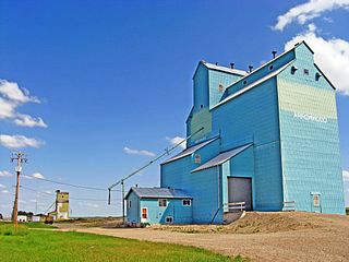
Arrowwood is a village in Vulcan County, Alberta, Canada. It is located on Highway 547, approximately 60 kilometres (37 mi) east of Okotoks.

Barons is a village in southern Alberta, Canada in a region referred to as Palliser's Triangle. It is located 51 kilometres (32 mi) north of Lethbridge along Highway 23. Barons was a filming location for a scene in the 1978 film Superman; the village's school was used to represent the school that young Clark Kent attended.
Lomond is a village in southern Alberta, Canada that is surrounded by Vulcan County. It is located at the intersection of Highway 845 and Highway 531, approximately 74 kilometres (46 mi) southwest of Brooks and 49 kilometres (30 mi) east of Vulcan. The village is a farming service community. Lomond was named for Loch Lomond, Scotland.

Nampa is a village in northern Alberta, Canada. It is 27 km (17 mi) south of the Town of Peace River on Highway 2. Heart River crosses the Highway 2 just north of community. Canadian National Railway owned railway traverses the village. Nampa is an Indigenous word for 'the Place'.

Nobleford is a town in southern Alberta, Canada that is approximately 32 km (20 mi) northwest of the City of Lethbridge. It has emerged as a bedroom community of Lethbridge.

Ryley is a village in central Alberta, Canada. It is surrounded by Beaver County, along Highway 14 between the City of Edmonton and the Town of Viking. The City of Camrose is approximately 58 km (36 mi) south of Ryley. The village was named in 1908 after George Urquhart Ryley, Grand Trunk Pacific Railway Land Commissioner at the time.
Rochon Sands is a summer village on Buffalo Lake in central Alberta, Canada. It is south of Rochon Sands Provincial Park. The summer village and the park take their name from the Rochon family who owned the land in the early 1900s.
Kapasiwin is a summer village in Alberta, Canada. It is located in the eastern shore of Wabamun Lake, south of Wabamun Lake Provincial Park and the Yellowhead Highway. The name derives from kapesiwin (ᑲᐯᓯᐃᐧᐣ), the Cree word for "campground". It was known as the Village of Wabamun Beach from 1913 to 1918.
South View is a summer village in Alberta, Canada. It is located on the northern shore of Isle Lake, opposite from Silver Sands.
Yellowstone is a summer village in Alberta, Canada. It is developed on the northern shore of Lac Ste. Anne, south of Alberta Highway 43, between Ross Haven and Gunn, 78 kilometres (48 mi) from Edmonton.
White Sands is a summer village in Alberta, Canada. It is located on the southeast shore of Buffalo Lake, northwest from the Town of Stettler and east of the Summer Village of Rochon Sands and Rochon Sands Provincial Park.
Silver Beach is a summer village in Alberta, Canada. It is located on the eastern shore of Pigeon Lake, west from Wetaskiwin.


