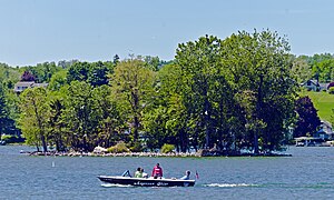
![]() Skenoh Island from Canandaigua City Pier | |
Etymology | "Skenoh" translates to "health" or "peace" in the Seneca language. Until 2021 the island was known as "Squaw Island". [1] |
---|---|
Geography | |
Coordinates | 42°52′12″N77°16′32″W / 42.87000°N 77.27556°W Coordinates: 42°52′12″N77°16′32″W / 42.87000°N 77.27556°W |
Adjacent to | Canandaigua Lake |
Area | 8,000 sq ft (740 m2) |
Length | 145 ft (44.2 m) |
Width | 55 ft (16.8 m) |
Administration | |
United States | |
State | New York |
County | Ontario |
Town | Canandaigua |
Skenoh Island is located at the north end of Canandaigua Lake, near the city of Canandaigua, New York, United States. It is one of two islands in the 11 Finger Lakes. [Note 1] Frequently it is described as New York's smallest state park; [2] however, while it is one of the state's smallest protected areas, it is not formally designated as a state park, but rather it is a "unique area" managed by the New York State Department of Environmental Conservation. [3] [4] The island was previously known as Squaw Island until October 2021, when the name was changed to remove the ethnic slur squaw . [1]
It formed from the alluvial deposits of nearby Sucker Brook. Limestone from the brook's bedrock dissolved in its waters forms rare lime carbonate oncolites, known locally as "water biscuits", on its shores. Rises in the lake level following the damming of Canandaigua Outlet have reduced the island to a small portion of its former land. The state and local activists have worked together to shore it up against erosion and prevent it from disappearing.
The island is located roughly 500 feet (150 m) south of the mouth of Sucker Brook and 600 feet (180 m) southwest of the end of the docks at the north end of the lake in Canandaigua. Although both those locations are in the city, the island itself is outside its boundaries, in the town of Canandaigua. [5] The surrounding waters, like much of the shallow north end of the lake, are no deeper than 25 feet (7.6 m) [6] it is sometimes possible to wade to it from shore. [2]
It is roughly 145 feet (44 m) long by 55 feet (17 m) wide, for a total area just under 8,000 square feet (740 m2). Several mature deciduous trees grow on the island; the shoreline is marked by large piles of flat stones. Its terrain is level, barely rising above the water level. A 10-short-ton (9.1 t) granite boulder is located in the middle. [2]
Canandaigua Lake, like all the Finger Lakes, was formed at the end of the last Ice Age about 11,000 years ago, from the glacial meltwater flooding the deep glacial moraines that typify the terrain of western Central New York. Skenoh Island began to form as a sandbar created by the interactions between the sediments carried in Sucker Brook and the counterclockwise currents along the lakeshore. Prior to European settlement, the island had two long gravel spits projecting to the north and southwest; the adjoining delta of the brook would have made the island easy to reach from land without boating to it, especially at times of year when the water was low. [7]
The first humans known to have settled in the region, the ancestors of the Iroquois Native American tribes, did not live on the island, even though it was larger than it is now. However, flint arrowheads and other artifacts found on the island suggest it was used for hunting waterfowl and perhaps deer. [8] It may also have been used as a staging area for Iroquois warriors in the area mobilizing against the Sullivan Expedition of 1779, during the Revolutionary War. [9]
While it is widely believed that the island got its original name of "Squaw Island" from its purported use as a place of refuge for Iroquois women during that time, the island's easy accessibility from the shore (even today) makes that use unlikely, and thus casts doubt on that story as the origin of the name. It seems more likely that it emerged from the island's use as a hunting and fishing spot. [2]
In 1900, paleontologist John M. Clarke published a paper about the rare oncolites that had long accumulated on the island's north shore. The disc-shaped white rocks, known locally as "water biscuits", were light yet strong when wet but brittle enough to break by hand when dry. [10] They were formed, Clarke wrote, when lime that had dissolved in the water from the limestone bedrock that Sucker Brook flowed over precipitated after algae that had grown on pebble or gravel substrates used up enough of the free carbon dioxide in the water, a process that repeated itself enough times to form the biscuits. He called it "a most interesting instance of the influence of plant growth upon lime deposits" and compared to similar phenomena recorded in European lakes that help explain the formation of similar structures found in fossil records elsewhere. [10]
Clarke's paper attracted the interest of Mary Clark Thompson, a Canandaigua native and daughter of former governor Myron H. Clark. After the 1899 death of her husband, New York City banker Frederick Ferris Thompson, she had returned to Sonnenberg Gardens, her estate in Canandaigua, and used the fortune she had inherited from him to finance civic improvements. She used her influence and connections to have the island, which had been state property since the 1794 Treaty of Canandaigua, declared a New York State Museum Reservation in 1918 in order to protect it. [Note 2] The following year she had the large granite boulder moved to the center of the island, [2] with an explanatory plaque affixed to it. [11]
Throughout the rest of the 20th century, Skenoh Island would face threats greater than those that could be held at bay by making it a protected area. Damming of Canandaigua Outlet drove up the lake's water level, leaving most of the two spits permanently underwater. [2] The delta was dredged out of existence in the late 1950s to allow better lake access from a marina to the west. [7] In 1975 it was made part of the state's newly created Natural and Historic Preservation Trust. [2]
Two years later the state's Department of Environmental Conservation (DEC), which by then managed the land, tried to sell it to the Town of Canandaigua, within whose boundaries the island sat, for $1. In the mid-1980s the state's Office of Parks, Recreation and Historic Preservation dredged Sucker Brook all the way to the Parrish Street bridge in the city of Canandaigua in order to expand facilities for a state marine park and boat launch. DEC sank cedar logs around the island and took other measures to protect its shores from erosion. [2]
The DEC currently designates the property as Skenoh Island Unique Area. [3] [4] Further protection efforts have been undertaken by a group of local citizen activists. [2]
As with other places with "squaw" in the name, efforts began in the 21st century to have the name changed, since the use of the term is seen as insensitive. [2] These efforts became successful with the announcement in October 2021 that the U.S. Board on Geographic Names had approved the name "Skenoh Island", effective immediately, based on recommendations from the New York State Geographic Names Committee, the New York State Museum and the Commissioner of the New York State Department of Environmental Conservation. The word "skenoh" translates to "health" or "peace" in the Seneca language. [1]
Cayuga Lake (,,) is the longest of central New York's glacial Finger Lakes, and is the second largest in surface area and second largest in volume. It is just under 39 miles (63 km) long. Its average width is 1.7 miles (2.8 km), and it is 3.5 mi wide (5.6 km) at its widest point, near Aurora. It is approximately 435 ft deep (133 m) at its deepest point, and has over 95 miles (153 km) of shoreline.
The Finger Lakes are a group of eleven long, narrow, roughly north–south lakes located south of Lake Ontario in an area called the Finger Lakes region in New York, in the United States. This region straddles the northern and transitional edge, known as the Finger Lakes Uplands and Gorges ecoregion, of the Northern Allegheny Plateau and the Ontario Lowlands ecoregion of the Great Lakes Lowlands.
Lake Ontario is one of the five Great Lakes of North America. It is bounded on the north, west, and southwest by the Canadian province of Ontario, and on the south and east by the U.S. state of New York. The Canada–United States border spans the centre of the lake.
The Mohawk River [TieonontatátieKanien'ké:ha for "a river flowing through a mountain"] is a 149-mile-long (240 km) river in the U.S. state of New York. It is the largest tributary of the Hudson River. The Mohawk flows into the Hudson in Cohoes, New York, a few miles north of the city of Albany. The river is named for the Mohawk Nation of the Iroquois Confederacy. It is a major waterway in north-central New York. The largest tributary, the Schoharie Creek, accounts for over one quarter (26.83%) of the Mohawk River's watershed. Another main tributary is the West Canada Creek, which makes up for 16.33% of the Mohawk's watershed.
Canandaigua Lake is the fourth largest of the Finger Lakes in the U.S. state of New York. The City of Canandaigua is located at the northern end of the lake and the village of Naples is several miles south of the southern end. It is the westernmost of the major Finger Lakes.
Southwick Beach State Park is a New York State park that lies along an unusual stretch of sandy beach on the eastern shore of Lake Ontario. The park is 464 acres (188 ha) in size with a 3,500 foot (1,100 m) length of beach, and is visited annually by about 100,000 people. Immediately to the south is the Lakeview Wildlife Management Area, which extends the publicly accessible beach by several miles. They are in the Town of Ellisburg in Jefferson County, New York south of the lakeside community of Jefferson Park.
Canandaigua Lake State Marine Park is a New York state park and boat launch located on the north shore of Canandaigua Lake in Ontario County, New York.
Onondaga Lake is a lake in Central New York, immediately northwest of and adjacent to Syracuse, New York. The southeastern end of the lake and the southwestern shore abut industrial areas and expressways; the northeastern shore and northwestern end border a series of parks and museums.
Otsego Lake is a 4,046-acre (16.37 km2) lake located in Otsego County in the U.S. state of New York. It is the source of the Susquehanna River and largest lake in Otsego County. The Village of Cooperstown is located at the lake's southern end. Glimmerglass State Park is located on the lake's northeastern shore, and includes Hyde Hall, a large mansion constructed in 1817, that overlooks the lake. The Glimmerglass Opera, opened in June 1987, is located on the western shore.
Canadice Lake is the smallest Finger Lake of western New York. The lake is located approximately 30 miles (48 km) south of Rochester. The name is derived from the Iroquois word ska-ne-a-dice, meaning long lake.
The Seneca River flows 61.6 miles (99.1 km) through the Finger Lakes region of Upstate New York in the United States. The main tributary of the Oswego River – the second-largest river flowing into Lake Ontario – the Seneca drains 3,468 square miles (8,980 km2) in parts of fourteen New York counties. The Seneca flows generally east, and is wide and deep with a gentle gradient. Much of the river has been channelized to form part of the Erie Canal.
Canadarago Lake is a 1,917-acre (7.76 km2) lake located in Otsego County, New York and is the source of Oaks Creek. The Village of Richfield Springs is located at the lake's northern end. It is the second largest lake in Otsego County, lying to the west of and parallel to the larger Otsego Lake. The lake's name is also spelled "Candajarago Lake" or "Caniadaraga Lake".
The Salmon River is a small river north of Syracuse in Upstate New York, the United States. It is a popular and economically important sportfishing destination, and the most heavily fished of New York's Lake Ontario tributaries. From its headwaters in the Tug Hill region of New York, it flows 44 miles (71 km) westward through two hydroelectric dams and over the 110-foot (34 m) Salmon River Falls before it empties into eastern Lake Ontario at Port Ontario in Oswego County. The Salmon River watershed drains approximately 280 square miles (730 km2).
Newfound Lake is located in Grafton County, New Hampshire, United States. It is situated in the Lakes Region of central New Hampshire, in the towns of Alexandria, Bridgewater, Bristol, and Hebron. Its area of 4,451 acres (18.0 km2) places it behind only Lake Winnipesaukee and Squam Lake among lakes located entirely within New Hampshire, and fourth in the state overall, when Umbagog Lake on the Maine border is included.
Rome Sand Plains is a 15,000-acre (61 km2) pine barrens about five miles (8.0 km) west of the city center of Rome in Oneida County in central New York. It consists of a mosaic of sand dunes rising about 50 feet (15 m) above low peat bogs that lie between the dunes. The barrens are covered with mixed northern hardwood forests, meadows, and wetlands. About 4,000 acres (16 km2) are protected in conservation preserves. Pine barrens are typical of seacoasts; the Rome Sand Plains is one of only a handful of inland pine barrens remaining in the United States. A second inland pine barrens, the Albany Pine Bush, is also found in New York, located north and west of state's capital Albany.
Sylvan Lake is located next to the community by that name in the Town of Beekman, New York, United States. It is the deepest and second-largest lake in Dutchess County.
Alpine Meadows is a ski resort in the western United States, located in Alpine Meadows, California. Near the northwest shore of Lake Tahoe, it offers 2,400 acres (9.7 km2) of skiable terrain, 13 different lifts, and a vertical drop of 1,802 feet (549 m).
Sucker Brook is a short stream that drains into the northwest corner of Canandaigua Lake, New York, United States. It flows in a 6-mile (9.7 km) hairpin-shaped course from uplands in the town of Canandaigua to the lake, in the eponymous city. The name comes from the white sucker fish abundant in its waters.
East Kill, a 16-mile-long (26 km) tributary of Schoharie Creek, flows across the town of Jewett, New York, United States, from its source on Stoppel Point. Ultimately its waters reach the Hudson River via the Mohawk. Since it drains into the Schoharie upstream of Schoharie Reservoir, it is part of the New York City water supply system. East Kill drains the southern slopes of the Blackhead Mountains, which include Thomas Cole Mountain, Black Dome, and Blackhead Mountain, the fourth-, third-, and fifth-highest peaks in the Catskills, respectively.
Muskrat Lake is a lake located south of Inlet, New York. Fish species present in the lake are brook trout, white sucker, and black bullhead. Access by carry down on the east shore.