Sky Valley, Georgia

Last updated

Sky Valley, Georgia
Sky Valley Way, Sky Valley, Georgia.JPG
Street in Sky Valley
SkyValleyGAseal.png
Rabun County Georgia Incorporated and Unincorporated areas Sky Valley Highlighted.svg
Location in Rabun County and the state of Georgia
Coordinates: 34°59′03″N83°19′53″W / 34.98417°N 83.33139°W / 34.98417; -83.33139
Country United States
State Georgia
County Rabun
Area
[1]
  Total3.07 sq mi (7.94 km2)
  Land3.04 sq mi (7.87 km2)
  Water0.03 sq mi (0.08 km2)
Elevation
[2]
3,500 ft (1,100 m)
Population
 (2020)
  Total482
  Density158.71/sq mi (61.28/km2)
Time zone UTC-5 (Eastern (EST))
  Summer (DST) UTC-4 (EDT)
ZIP code
30537
Area code 706
FIPS code 13-71282 [3]
GNIS feature ID2405468 [2]
Website skyvalleyga.com

Sky Valley is a city in Rabun County, Georgia, United States and is nestled in a mountain valley on the northwest slopes of Rabun Bald, Georgia's second-highest peak. Incorporated in March 1978, [4] it recorded a total population of 250 as of the 2000 U.S. census, and 482 as of 2020. Sky Valley shares ZIP code 30537 with nearby Dillard.

Contents

Since 1969, it is home to Sky Valley Resort (now renamed Sky Valley Country Club), which features championship golf, [5] championship croquet, [6] tennis, and swimming, and formerly downhill skiing.

Ski area

The resort formerly had the only winter ski area in Georgia, but after changing ownership in 2004, the resort's ski slopes were permanently closed after 35 years. [7] [8]

The former ski lodge at 696 Sky Valley Way now houses a church under its two unique eight-gabled roofs, while the chairlift house and equipment-rental shop were demolished in January 2007. To the immediate south of this, condos were built on the north-facing slope which previously had the five ski runs, named Panorama, Scooter, Kamikaze, Gravity's Revenge, and Pokey, the last of which was the bunny slope for children with its own rope tow. These provided 15–16 acres (6.1–6.5 ha) of skiable terrain with a vertical drop of 210 feet (64 m).

Only three other aerial lifts remain in Georgia: the Sky Buckets open-air gondola at Six Flags Over Georgia, and the Summit Skyride tram to the top of Stone Mountain, both in metro Atlanta; and the chairlift across Lake Winnepesaukah, an amusement park even closer to Georgia's northern state line in Rossville, a suburb adjoining Chattanooga, Tennessee.

After the closures of Sky Valley's ski operations and Ski Scaly, Sapphire Valley is the nearest ski area, while Cloudmont in far northeast Alabama remains the southernmost in the eastern U.S. since 1970, beating Sky Valley after only a year. Four western ski areas go as far south as the latitude of middle Georgia, while Mexico's only ski area is slightly further south than Miami.

Transportation

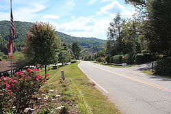
The only highway or other significant through-road is the Dillard/Highlands Road (Georgia 246 and N.C. 106) between Dillard, Georgia and Highlands, North Carolina. The northern city limit is the North Carolina state line, where the highway zigzags, crossing in five different places (two of which are into and out of the city). Due to surveying errors more than 200 years ago, the boundary is considerably further south than the 35°N specified at the time by Congress.

Because of this, the main road into Sky Valley from the highway is actually within the community of Scaly Mountain, North Carolina, which also had a ski area that closed in 2004 but offers snow tubing each winter since then. Beginning at a small intersection that is bisected by exactly 35°N, Old Mud Creek Road travels south and becomes Bald Mountain Road at the state line, then curving east as the city's main street (though there is no downtown or business district per se) and eventually ending at Hale Ridge Road just south of the state line.

The main entrance was originally to be a new road from Ga. 246 instead of N.C. 106, however GDOT denied this for safety reasons. Around 1980, a covered bridge was built along the highway for this entrance, but was never used, and still stands as of 2019.

Geography and climate

Sky Valley is the northernmost city in the state.

According to the United States Census Bureau, the city has a total area of 3.0 square miles (7.8 km2), all land. The elevation of the valley floor is approximately 3100 feet above sea level, while areas within the city limits on the slopes of Rabun Bald exceed 4200 feet. Sky Valley is Georgia's highest incorporated city and one of the highest municipalities in the eastern United States.

Under the Köppen climate classification, Sky Valley has a temperate subtropical highland climate (Köppen Cfb), a rarity in the southeastern US, due to its high elevation. The city is also one of the coldest locations in Georgia with the January average temperature 34.0 °F (1.1 °C) and the July average temperature of 69.0 °F (20.6 °C).

Climate data for Sky Valley
MonthJanFebMarAprMayJunJulAugSepOctNovDecYear
Mean daily maximum °F (°C)45.0
(7.2)
48.4
(9.1)
56.5
(13.6)
65.1
(18.4)
72.0
(22.2)
77.4
(25.2)
79.9
(26.6)
79.0
(26.1)
73.9
(23.3)
65.7
(18.7)
56.5
(13.6)
47.7
(8.7)
63.9
(17.7)
Daily mean °F (°C)34.0
(1.1)
36.7
(2.6)
44.1
(6.7)
52.0
(11.1)
59.5
(15.3)
65.8
(18.8)
69.1
(20.6)
68.4
(20.2)
63.0
(17.2)
53.2
(11.8)
44.6
(7.0)
36.9
(2.7)
52.3
(11.3)
Mean daily minimum °F (°C)23.2
(−4.9)
25.0
(−3.9)
31.8
(−0.1)
39.0
(3.9)
47.1
(8.4)
54.3
(12.4)
58.3
(14.6)
57.7
(14.3)
52.2
(11.2)
39.6
(4.2)
32.7
(0.4)
26.1
(−3.3)
40.6
(4.8)
Average precipitation inches (mm)6.7
(169)
6.7
(169)
7.9
(200)
6.1
(155)
6.5
(165)
6.1
(155)
6.3
(160)
6.2
(157)
5.8
(148)
5.4
(138)
6.3
(160)
6.9
(175)
76.9
(1,951)
Source: [9]

Demographics

Historical population
CensusPop.Note
1980 65
1990 187187.7%
2000 22118.2%
2010 27223.1%
2020 48277.2%
U.S. Decennial Census [10]

As of the census [3] of 2000, there were 221 people, 112 households, and 81 families residing in the city. The population density was 72.9 inhabitants per square mile (28.1/km2). There were 675 housing units at an average density of 222.6 per square mile (85.9/km2). The racial makeup of the city was 95.48% White, 4.07% African American, and 0.45% from two or more races.

There were 112 households, out of which 11.6% had children under the age of 18 living with them, 67.9% were married couples living together, 4.5% had a female householder with no husband present, and 26.8% were non-families. 25.0% of all households were made up of individuals, and 16.1% had someone living alone who was 65 years of age or older. The average household size was 1.97 and the average family size was 2.30.

In the city the population was spread out, with 9.5% under the age of 18, 2.3% from 18 to 24, 8.1% from 25 to 44, 34.4% from 45 to 64, and 45.7% who were 65 years of age or older. The median age was 64 years. For every 100 females, there were 87.3 males. For every 100 females age 18 and over, there were 88.7 males.

In 2010 the largest self-identified ancestry/ethnic groups were:

The median income for a household in the city was $44,750, and the median income for a family was $57,500. Males had a median income of $41,875 versus $13,750 for females. The per capita income for the city was $31,511. About 5.6% of families and 4.8% of the population were below the poverty line, including 5.3% of those under the age of eighteen and 1.8% of those 65 or over.

Related Research Articles

<span class="mw-page-title-main">Watauga County, North Carolina</span> County in North Carolina, United States

Watauga County is a county located in the U.S. state of North Carolina. As of the 2020 census, the population was 54,086. Its county seat and largest community is Boone. The county is in an exceptionally mountainous region, known as the High Country. It is the home of Appalachian State University, which has approximately 20,023 students as of August 2020. Watauga County comprises the Boone, NC Micropolitan Statistical Area.

<span class="mw-page-title-main">Clearwater County, Idaho</span> County in Idaho, United States

Clearwater County is a county located in the U.S. state of Idaho. As of the 2020 census, the population was 8,734. The county seat is Orofino. Established in 1911, the county was named after the Clearwater River.

<span class="mw-page-title-main">Towns County, Georgia</span> County in Georgia, United States

Towns County is a county located in the northeastern part of the U.S. state of Georgia. As of the 2020 census, the population was 12,493. Its county seat is Hiawassee. The county was created on March 6, 1856, and named for lawyer, legislator, and politician George W. Towns.

<span class="mw-page-title-main">Rabun County, Georgia</span> County in Georgia, United States

Rabun County is the north-easternmost county in the U.S. state of Georgia. As of the 2020 census, the population was 16,883, up from 16,276 in 2010. The county seat is Clayton. With an average annual rainfall of over 70 inches (1,800 mm), Rabun County has the title of the rainiest county in Georgia and is one of the rainiest counties east of the Cascades. The year 2018 was the wettest on record in the county's history. The National Weather Service cooperative observation station in northwest Rabun's Germany Valley measured 116.48 inches of rain during the year. During 2020, the Germany Valley NWS station reported a yearly precipitation total of 100.19 inches.

<span class="mw-page-title-main">Gilmer County, Georgia</span> County in Georgia, United States

Gilmer County is a county located in the north central portion of the U.S. state of Georgia. As of the 2020 census, the population was 31,353. The county seat is Ellijay. named for a historic Cherokee town also spelled as Elejoy in the eighteenth century. The county was created on December 3, 1832, and was named for George Rockingham Gilmer, a politician who served two non-consecutive terms as governor of the state. Gilmer County is home of the annual Apple Festival, which is held in mid-October. Ninety percent of the land is in cropland and forest. Poultry raising and processing makes up the largest portion of the agricultural economy, which generates 33.2% of the total revenues. Manufacturing is about 20%.

<span class="mw-page-title-main">Valley, Alabama</span> City in Alabama, United States

Valley is a city in Chambers County, Alabama, United States. Valley was incorporated in 1980 combining the four textile mill villages of Fairfax, Langdale, River View, and Shawmut. As of the 2020 census it had a population of 10,529. The city lies on the western bank of the Chattahoochee River, the state border between Alabama and Georgia. Valley is a pilot city for the Alabama Communities of Excellence program, a non-profit that partners with governments, businesses, and universities to prepare participating communities for a more vibrant future. It is included in the LaGrange, Georgia Micropolitan Statistical Area, which is included in the Greater Atlanta Combined Statistical Area.

<span class="mw-page-title-main">Diamond Ridge, Alaska</span> Census-designated place in Alaska, United States

Diamond Ridge is a census-designated place (CDP) just outside Homer in Kenai Peninsula Borough, Alaska, United States. At the 2010 census the population was 1,156, down from 1,802 in 2000.

<span class="mw-page-title-main">Vail, Colorado</span> Town in Colorado, United States

Vail is a home rule municipality in Eagle County, Colorado, United States. The population of the town was 4,835 in 2020. Home to Vail Ski Resort, the largest ski mountain in Colorado, the town is known for its hotels, dining, and for the numerous events the city hosts annually, such as the Vail Film Festival, Vail Resorts Snow Days, and Bravo! Vail.

<span class="mw-page-title-main">Clayton, Georgia</span> City in Georgia, United States

Clayton is a city in Rabun County, Georgia, United States. Its population was 2,003 at the 2020 census. The county seat of Rabun County, it is in the Blue Ridge Mountains.

<span class="mw-page-title-main">Dillard, Georgia</span> City in Georgia, United States

Dillard is a town in Rabun County, Georgia, United States. As of the 2020 census, the city population was 337.

<span class="mw-page-title-main">Mountain City, Georgia</span> Town in Georgia, United States

Mountain City is an incorporated town in Rabun County, Georgia, United States. The population was 904 at the 2020 census. The town straddles the Eastern Continental Divide in a deep gap in the Blue Ridge Mountain front. The gap allows U.S. Route 441 to cross the range at an elevation of 2168 feet without the significant grade required by roadways at most other mountain passes along the Georgia Blue Ridge.

<span class="mw-page-title-main">Tiger, Georgia</span> Town in Georgia, United States

Tiger is a town in Rabun County, Georgia, United States. The population was 574 at the 2020 census, up from 408 at the 2010 census.

<span class="mw-page-title-main">Ketchum, Idaho</span> City in Idaho, United States

Ketchum is a city in Blaine County, Idaho, United States. Located in the central part of the state, the population was 3,555 at the 2020 census, up from 2,689 in 2010. Located in the Wood River Valley, Ketchum is adjacent to Sun Valley and the communities share many resources: both sit in the same valley beneath Bald Mountain, with its skiing. The city also draws tourists to its fishing, hiking, trail riding, tennis, shopping, art galleries, and more. The airport for Ketchum, Friedman Memorial Airport, is approximately 15 miles (24 km) south in Hailey.

<span class="mw-page-title-main">Sun Valley, Idaho</span> City in Idaho, United States

Sun Valley is a resort city in the western United States, in Blaine County, Idaho, adjacent to the city of Ketchum in the Wood River valley. The population was 1,783 at the 2020 census. The elevation of Sun Valley is 5,920 feet (1,805 m) above sea level.

<span class="mw-page-title-main">McCall, Idaho</span> City in Idaho, United States

McCall is a resort town on the western edge of Valley County, Idaho, United States. Named after its founder, Tom McCall, it is situated on the southern shore of Payette Lake, near the center of the Payette National Forest. The population was 2,991 as of the 2010 census, up from 2,084 in 2000.

<span class="mw-page-title-main">Kingsford, Michigan</span> City in Michigan, United States

Kingsford is a city in Dickinson County, Michigan, United States. Its population was 5,139 at the 2020 census, a slight increase from the 5,133 recorded at the 2010 census. It was named for the developer Edward G. Kingsford.

<span class="mw-page-title-main">Ishpeming, Michigan</span> City in Michigan, United States

Ishpeming is a city in Marquette County, Michigan, United States. Located in the Upper Peninsula, the population was 6,140 at the 2020 census, less than it was in the 1950s and 1960s when the Iron ore mines employed more workers. A statue of a Native American figure, erected in 1884 in the small town square, is referred to as "Old Ish".

<span class="mw-page-title-main">Whitefish, Montana</span> City in Montana, United States

Whitefish is a city in Flathead County, Montana, United States. According to the 2020 United States Census, there were 7,751 people in the city.

<span class="mw-page-title-main">Waterville Valley, New Hampshire</span> Town in New Hampshire, United States

Waterville Valley is a New England town in Grafton County, New Hampshire, United States. The population was 508 at the 2020 census, up from 247 at the 2010 census.

<span class="mw-page-title-main">Heber City, Utah</span> City in Utah, United States

Heber City is a city and county seat of Wasatch County, Utah. The population was 16,856 as of the 2020 United States census. The city is located 43 miles southeast of Salt Lake City.

References

  1. "2020 U.S. Gazetteer Files". United States Census Bureau. Retrieved December 18, 2021.
  2. 1 2 U.S. Geological Survey Geographic Names Information System: Sky Valley, Georgia
  3. 1 2 "U.S. Census website". United States Census Bureau . Retrieved January 31, 2008.
  4. "History". City of Sky Valley Georgia.
  5. "Sky Valley Country Club - About". Sky Valley Country Club. Retrieved November 20, 2022.
  6. "Club Profile: Sky Valley Croquet Club". issuu. Retrieved May 22, 2022.
  7. "Remembering Sky Valley Ski Area – by Scott Fagan". January 20, 2007. Retrieved June 21, 2015.
  8. "A Tribute to Official Home Page". www.skyvalleyga.com. Archived from the original on November 8, 2005.
  9. "Sky Valley climate: Average Temperature, weather by month, Sky Valley weather averages - Climate-Data.org". en.climate-data.org.
  10. "Census of Population and Housing". Census.gov. Retrieved June 4, 2015.
  11. Bureau, U. S. Census. "U.S. Census website". United States Census Bureau . Retrieved July 9, 2019.