Smeltertown, Colorado

Last updated

Smeltertown, Colorado
Ohio-Colorado Smelting and Refining Company Smokestack.JPG
The old Ohio-Colorado Smelting and Refining Company Smokestack is located in Smeltertown.
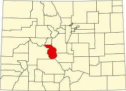
Chaffee County Colorado Incorporated and Unincorporated areas Smeltertown Highlighted 0871625.svg
Location of the Smeltertown CDP in Chaffee County, Colorado.
Usa edcp location map.svg
Red pog.svg
Smeltertown
Location of the Smeltertown CDP in the United States.
Coordinates: 38°33′08″N106°00′30″W / 38.55222°N 106.00833°W / 38.55222; -106.00833 (Smeltertown CDP, Colorado) [1]
Country Flag of the United States.svg  United States
State Flag of Colorado.svg  Colorado
County Chaffee County
Government
[1]
  Type unincorporated community
Area
[2]
  Total0.146 sq mi (0.378 km2)
  Land0.146 sq mi (0.378 km2)
  Water0.000 sq mi (0.000 km2)
Elevation
[1]
7,143 ft (2,177 m)
Population
 (2020) [3]
  Total88
  Density600/sq mi (230/km2)
Time zone UTC-7 (MST)
  Summer (DST) UTC-6 (MDT)
ZIP Code [4]
Salida 81201
Area code 719
GNIS feature ID 2583297 [1]

Smeltertown is an unincorporated community and a census-designated place (CDP) located in and governed by Chaffee County, Colorado, United States. The population of the Smeltertown CDP was 88 at the United States Census 2020. [3] The Salida post office (Zip Code 81201) serves the area. [4]

Contents

Geography

The Smeltertown CDP has an area of 93 acres (0.378 km2), all land. [2]

Demographics

The United States Census Bureau initially defined the Smeltertown CDP for the United States Census 2010.

Smeltertown CDP, Colorado
YearPop.±%
2010 120    
2020 88−26.7%
Source: United States Census Bureau

See also

Related Research Articles

<span class="mw-page-title-main">Chaffee County, Colorado</span> County in Colorado, United States

Chaffee County is a county located in the U.S. state of Colorado. As of the 2020 census, the population was 19,476. The county seat is Salida.

<span class="mw-page-title-main">Columbine, Colorado</span> Census-designated place in Jefferson and Arapahoe counties in Colorado, United States

Columbine is a census-designated place (CDP) in and governed by Jefferson and Arapahoe counties in Colorado, United States. The CDP is a part of the Denver metropolitan area. Located primarily in Jefferson County, Columbine lies immediately south of Denver. The population of the Columbine CDP was 25,229 at the 2020 census. The community lies in ZIP code 80123.

<span class="mw-page-title-main">Salida, Colorado</span> City in Colorado, United States

Salida is the statutory city that is the county seat and the most populous municipality of Chaffee County, Colorado, United States. The population was 5,666 at the 2020 census.

<span class="mw-page-title-main">Air Force Academy, Colorado</span> Census Designated Place in State of Colorado, United States

The Air Force Academy is a census-designated place (CDP) located in El Paso County, Colorado, United States. The CDP includes the developed portion of the United States Air Force Academy, including the cadet housing facilities. The CDP is a part of the Colorado Springs, CO Metropolitan Statistical Area. The USAF Academy post office (ZIP Codes 80840 and 80841 serves the area. At the United States Census 2020, the population of the Air Force Academy CDP was 6,680.

<span class="mw-page-title-main">Genesee, Colorado</span> Census Designated Place in Colorado, United States

Genesee is an unincorporated community and a census-designated place (CDP) located in and governed by Jefferson County, Colorado, United States. The CDP is a part of the Denver–Aurora–Lakewood, CO Metropolitan Statistical Area. The population of the Genesee CDP was 3,610 at the United States Census 2020. The Golden post office serves the area.

<span class="mw-page-title-main">Aristocrat Ranchettes, Colorado</span> Census Designated Place in Colorado, United States

Aristocrat Ranchettes is an unincorporated community and a census-designated place (CDP) located in and governed by Weld County, Colorado, United States. The population of the Aristocrat Ranchettes CDP was 1,715 at the United States Census 2020. The Fort Lupton post office (Zip Code 80621) serves the area. The CDP is a part of the Greeley, CO Metropolitan Statistical Area.

<span class="mw-page-title-main">Johnson Village, Colorado</span> Census Designated Place in Colorado, United States

Johnson Village is an unincorporated community and a census-designated place (CDP) located in and governed by Chaffee County, Colorado, United States. The population of the Johnson Village CDP was 299 at the United States Census 2020. The Buena Vista post office serves the area.

<span class="mw-page-title-main">Cherry Creek, Colorado</span> Census Designated Place in Colorado, United States

Cherry Creek is an unincorporated community and a census-designated place (CDP) located in and governed by Arapahoe County, Colorado, United States. The CDP is a part of the Denver–Aurora–Lakewood, CO Metropolitan Statistical Area. The population of the Cherry Creek CDP was 11,488 at the United States Census 2020. The ZIP code 80111 serves the area.

<span class="mw-page-title-main">Coaldale, Colorado</span> Census-designated place in Fremont County, Colorado, United States

Coaldale is a census-designated place (CDP) and post office located in and governed by Fremont County, Colorado, United States. The CDP is a part of the Cañon City, CO Micropolitan Statistical Area. The Coaldale post office has the ZIP Code 81222. At the United States Census 2020, the population of the Coaldale CDP was 343.

<span class="mw-page-title-main">Howard, Colorado</span> Census-designated place in Fremont County, Colorado, United States

Howard is a census-designated place (CDP) and post office in and governed by Fremont County, Colorado, United States. The CDP is a part of the Cañon City, CO Micropolitan Statistical Area. The Howard post office has the ZIP Code 81233. At the United States Census 2020, the population of the Howard CDP was 852.

<span class="mw-page-title-main">Nathrop, Colorado</span> Census Designated Place in Colorado, United States

Nathrop is an unincorporated town, a post office, and a census-designated place (CDP) located in and governed by Chaffee County, Colorado, United States. The population was 288 at the 2020 census. The Nathrop post office has the ZIP code 81236.

<span class="mw-page-title-main">Ellicott, Colorado</span> Census Designated Place in Colorado, United States

Ellicott is an unincorporated community and a census-designated place (CDP) located in and governed by El Paso County, Colorado, United States. The CDP is a part of the Colorado Springs, CO Metropolitan Statistical Area. The population of the Ellicott CDP was 1,248 at the United States Census 2020. The Calhan post office serves the area.

<span class="mw-page-title-main">Aetna Estates, Colorado</span> Census Designated Place in Colorado, United States

Aetna Estates is an unincorporated community and a census-designated place (CDP) located in and governed by Arapahoe County, Colorado, United States. The CDP is a part of the Denver–Aurora–Lakewood, CO Metropolitan Statistical Area. The population of the Aetna Estates CDP was 1,496 at the United States Census 2020. The unincorporated community is surrounded by Aurora and lies in ZIP Code 80018.

<span class="mw-page-title-main">Bonanza Mountain Estates, Colorado</span> Census Designated Place in Colorado, United States

Bonanza Mountain Estates is an unincorporated community and a census-designated place (CDP) located in and governed by Boulder County, Colorado, United States. The CDP is a part of the Boulder, CO Metropolitan Statistical Area. The population of the Bonanza Mountain Estates CDP was 127 at the United States Census 2020. The Nederland post office serves the area.

<span class="mw-page-title-main">Lazy Acres, Colorado</span> Census Designated Place in Colorado, United States

Lazy Acres is an unincorporated community and a census-designated place (CDP) located in and governed by Boulder County, Colorado, United States. The CDP is a part of the Boulder, CO Metropolitan Statistical Area. The population of the Lazy Acres CDP was 957 at the United States Census 2020. The Boulder post office serves the area.

<span class="mw-page-title-main">Tall Timber, Colorado</span> Census Designated Place in Colorado, United States

Tall Timber is an unincorporated community and a census-designated place (CDP) located in and governed by Boulder County, Colorado, United States. The CDP is a part of the Boulder, CO Metropolitan Statistical Area. The population of the Tall Timber CDP was 185 at the United States Census 2020. The Boulder post office serves the area.

<span class="mw-page-title-main">Chacra, Colorado</span> Census-designated places in Garfield County, Colorado, United States

Chacra is a census-designated place (CDP) in and governed by Garfield County, Colorado, United States. The CDP is a part of the Glenwood Springs, CO Micropolitan Statistical Area. The population of the Chacra CDP was 331 at the United States Census 2020. The Glenwood Springs post office serves the area.

<span class="mw-page-title-main">Garfield, Colorado</span> Census Designated Place in Colorado, United States

Garfield is an unincorporated community and a census-designated place (CDP) located in and governed by Chaffee County, Colorado, United States. The population of the Garfield CDP was 27 at the United States Census 2020. The Salida post office serves the area.

<span class="mw-page-title-main">Maysville, Colorado</span> Census Designated Place in Colorado, United States

Maysville is an unincorporated community and a census-designated place (CDP) located in and governed by Chaffee County, Colorado, United States. The population of the Maysville CDP was 173 at the United States Census 2020. The Salida post office serves the area.

<span class="mw-page-title-main">Brook Forest, Colorado</span> Census Designated Place in Colorado, United States

Brook Forest is an unincorporated community and a census-designated place (CDP) located in and governed by Jefferson and Clear Creek counties, Colorado, United States. The population was 622 at the 2020 census. The CDP is a part of the Denver–Aurora–Lakewood, CO Metropolitan Statistical Area. The Evergreen Post Office serves the area.

References

  1. 1 2 3 4 U.S. Geological Survey Geographic Names Information System: Smeltertown, Colorado
  2. 1 2 "State of Colorado Census Designated Places - BAS20 - Data as of January 1, 2020". United States Census Bureau . Retrieved December 20, 2020.
  3. 1 2 United States Census Bureau. "Smeltertown CDP, Colorado" . Retrieved April 17, 2023.
  4. 1 2 "Look Up a ZIP Code". United States Postal Service . Retrieved January 13, 2021.