Souillac, Lot

Last updated

Souillac
Souillac vueGenerale.jpg
A general view of Souillac
Blason ville fr Souillac (Lot).svg
Location of Souillac
Souillac, Lot
France location map-Regions and departements-2016.svg
Red pog.svg
Souillac
Languedoc-Roussillon-Midi-Pyrenees region location map.svg
Red pog.svg
Souillac
Coordinates: 44°54′02″N1°28′44″E / 44.9006°N 1.479°E / 44.9006; 1.479
Country France
Region Occitania
Department Lot
Arrondissement Gourdon
Canton Souillac
Intercommunality Causses et Vallée de la Dordogne
Government
  Mayor (20202026) Gilles Liébus [1]
Area
1
25.92 km2 (10.01 sq mi)
Population
 (2022) [2]
3,199
  Density120/km2 (320/sq mi)
Time zone UTC+01:00 (CET)
  Summer (DST) UTC+02:00 (CEST)
INSEE/Postal code
46309 /46200
Elevation80–314 m (262–1,030 ft)
(avg. 221 m or 725 ft)
1 French Land Register data, which excludes lakes, ponds, glaciers > 1 km2 (0.386 sq mi or 247 acres) and river estuaries.

Souillac (French pronunciation: [sujak] ; Languedocien: Solhac) is a commune in the Lot department in south-western France, on the river Dordogne. It is the site of the Brive–Souillac Airport, which opened in 2010. The town hosts an annual jazz festival in July. The abbey church has famous Romanesque carvings.

Contents

History

Souillac grew up around an abbey dependent on the Benedictine monastery of Aurillac (Cantal). [3] Two donors help start the community, Count Geraud, Abbot of Aurillac and Viscount Frotard in 909. [3] [4] :3 When the Benedictines settled in the plain of Souillès, so named from a local word "souilh" meaning muddy and marshy place where wild boars wallowed, they replaced a community supposedly founded there by Saint Eloi. [3] The monks drained and transformed the swamp into a rich estate. The stone abbey church Abbatiale Sainte Marie was built in the 1100s and was completed in 1145. [3]

During the Hundred Years' War, the English troops besieged and occupied the town twice, once in 1351 and again in 1356. [3] The abbey was granted its independence in 1473. [3]

On 3 December 1508, as a result of a papal bull, the monastery was officially designated as an abbey. [5] :5 The French Wars of Religion brought further trouble to the town and abbey, both ransacked by Protestant forces between 1562 and 1573 and the parish church Saint-Martin was destroyed. [3] [4] :8 The monastery buildings were burnt, the church ransacked and an attempt made to blow up its walls. [4] :8

Restoration of the Abbey church and the monastery buildings began in 1632 by the lord-abbot Henry de la Mothe Houdancourt and was completed by 1712. [4] :8 By 1658, the abbey was now under the control of the Congregation of Saint Maur. [3] The French Revolution brought the end to the abbey. The Constituent Assembly announced the confiscation of all church assets by the state on 2 November 1789. [5] :5 With a decree on 14 April 1790, it returned the Abbey to the civil authority to sell its assets with just the Eglise Sainte-Marie now remaining. [3] [4] :9 The monks were expelled on 25 November 1790 and the assets sold the same day for 11,000 livres. [4] :9 [5] :5

The abbey church was turned into a Temple of Reason in March 1794. [4] :9 It reopened as a church in 1801 and received its first priest in 1803 as a parish church. [4] :9 Repairs on the church continued until 1838 and it was proclaimed a national monument in 1841. [5] :5 The state took over the repairs of the exterior between 1842 and 1848 including two aspses. [5] :5

Geography

Souillac is in the upper Dordogne Valley where the river cuts through the limestone plateau of Haut-Quercy, a historic name for the northern part of the Department of Lot. This is part of the Massif Central, an elevated region in south central France. To the north of Souillac lies the commune of Lachapelle-Auzac, to the east Mayrac and Pinsac, to the south Lanzac, to the south west Peyrillac-et-Millac and Cazoulès, to the west Orliaguet and to the northwest Salignac-Eyvigues, Borrèze and Gignac. [6] Souillac station has rail connections to Brive-la-Gaillarde, Cahors and Toulouse.

Town

Souillac is a small market town and is the hub for the area. This is an agricultural region which is known for its walnuts, strawberries and quiet, rural way of life. [7]

Demographics

Historical population
YearPop.±% p.a.
1968 3,630    
1975 3,845+0.83%
1982 3,570−1.05%
1990 3,459−0.39%
1999 3,671+0.66%
2007 3,911+0.79%
2012 3,615−1.56%
2017 3,284−1.90%
Source: INSEE [8]

Culture and contemporary life

Places and monuments

Tourism

The town is on the main railway line from Paris to Toulouse and is about 15 km (9 mi) south of the Brive–Souillac Airport which has international flights. The most notable building in the town is the abbey church of Sainte-Marie. The domed roofs are similar to but rather smaller than those of Périgueux Cathedral. Fragments of the original Romanesque sculptures are grouped just inside the west door. Behind the abbey church is the Musée de l'Automate which has a large collection of mechanical figures and dolls. [7]

An international jazz festival is held annually in the town in July. [14] The festival was started in 1976 by a group of volunteers enthused by Sim Copans, a United States Army non-combatant in World War I who came to live in nearby Lanzac. The festival features live concerts and other jazz-related activities. [14]

See also

Related Research Articles

<span class="mw-page-title-main">Cruas</span> Commune in Auvergne-Rhône-Alpes, France

Cruas is a commune near the river Rhône in the Ardèche department in southern France.

<span class="mw-page-title-main">Figeac</span> Subprefecture and commune in Occitania, France

Figeac is a commune in the southwestern French department of Lot. Figeac is a sub-prefecture of the department.

<span class="mw-page-title-main">Sarlat-la-Canéda</span> Subprefecture and commune in Nouvelle-Aquitaine, France

Sarlat-la-Canéda, commonly known as Sarlat, is a commune in the southwestern French department of Dordogne, a part of Nouvelle-Aquitaine. Sarlat and La Canéda were distinct towns until merged into one commune in March 1965.

<span class="mw-page-title-main">Jumièges</span> Commune in Normandy, France

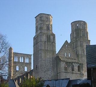
Jumièges is a commune in the Seine-Maritime department in the Normandy region in north-western France.

<span class="mw-page-title-main">Sainte-Orse</span> Commune in Nouvelle-Aquitaine, France

Sainte-Orse is a commune in the Dordogne department in Nouvelle-Aquitaine in southwestern France. The church of Saint Ursus dates from the 11th-12th century. The castle dates from the 15th-16th century.

<span class="mw-page-title-main">Fénétrange</span> Commune in Grand Est, France

Fénétrange is a commune in the Moselle department in Grand Est in north-eastern France.

<span class="mw-page-title-main">Vif, Isère</span> Commune in Auvergne-Rhône-Alpes, France

Vif is a commune in the Isère department in southeastern France.

<span class="mw-page-title-main">Janzé</span> Commune in Brittany, France

Janzé is a commune in the Ille-et-Vilaine department in Brittany in northwestern France. It is also the seat of the Canton of Janzé. The inhabitants of Janzé are called Janzéens in French.

Sioniac is a commune in the Corrèze department of Nouvelle-Aquitaine region in central France.

<span class="mw-page-title-main">Granges-d'Ans</span> Commune in Nouvelle-Aquitaine, France

Granges-d'Ans is a commune in the Dordogne department in Nouvelle-Aquitaine in southwestern France. As part of the Pays d'Ans, it shares a link with the neighbouring communes of Badefols-d'Ans, La Boissière-d'Ans, Chourgnac d’Ans, Sainte-Eulalie-d'Ans and Saint-Pantaly-d'Ans.

<span class="mw-page-title-main">Saint-Amand-de-Coly</span> Part of Coly-Saint-Amand in Nouvelle-Aquitaine, France

Saint-Amand-de-Coly is a former commune in the Dordogne department in Nouvelle-Aquitaine in southwestern France. On 1 January 2019, it was merged into the new commune Coly-Saint-Amand.

<span class="mw-page-title-main">Saint-Chef</span> Commune in Auvergne-Rhône-Alpes, France

Saint-Chef is a commune in the Isère department in southeastern France.

<span class="mw-page-title-main">Saint-Céré</span> Commune in Occitania, France

Saint-Céré is a commune in the Lot department, southern France. The commune includes within its borders the castle of Saint-Laurent-les-Tours, where the artist Jean Lurçat lived and worked for many years, and from which he operated a secret radio for the French Resistance. The castle still houses a collection of his works.

<span class="mw-page-title-main">Cuncy-lès-Varzy</span> Commune in Bourgogne-Franche-Comté, France

Cuncy-lès-Varzy is a commune in the Nièvre department in central France. It is located 6 km northeast of the town of Varzy and 15 km southeast of Clamecy.

Gouffern en Auge is a commune in the department of Orne, northwestern France. The municipality was established on 1 January 2017 by merger of the former communes of Silly-en-Gouffern, Aubry-en-Exmes, Avernes-sous-Exmes, Le Bourg-Saint-Léonard, Chambois, La Cochère, Courménil, Exmes, Fel, Omméel, Saint-Pierre-la-Rivière, Survie, Urou-et-Crennes and Villebadin.

<span class="mw-page-title-main">French Romanesque architecture</span> Medieval architectural style

Romanesque architecture appeared in France at the end of the 10th century, with the development of feudal society and the rise and spread of monastic orders, particularly the Benedictines, which built many important abbeys and monasteries in the style. It continued to dominate religious architecture until the appearance of French Gothic architecture in the Île-de-France between about 1140 and 1150.

<span class="mw-page-title-main">Église Saint-Martin, Marmoutier</span> Church in Marmoutier, France

Église Saint-Martin is the parish church of the small commune of Marmoutier, in the Bas-Rhin department of France. The church used to belong to Marmoutier Abbey and to be dedicated to Saint Stephen; it is still known as église (church), or abbatialeSaint-Étienne.

Preuilly Abbey was a Benedictine monastery in Preuilly-sur-Claise, Indre-et-Loire, France. The surviving abbey church retains many Romanesque features, notably the intricately carved capitals.

<span class="mw-page-title-main">Château Cramirat</span> Château in Dordogne, France

Château Cramirat is a 12th-century Templar castle in the village of Sergeac, Dordogne (Nouvelle-Aquitaine), southwest France. A French national historic monument, the château is situated in the heart of the Vézère river valley, a UNESCO World Heritage Site known as the Valley of Mankind.

References

  1. "Répertoire national des élus: les maires" (in French). data.gouv.fr, Plateforme ouverte des données publiques françaises. 13 September 2022.
  2. "Populations de référence 2022" (in French). The National Institute of Statistics and Economic Studies. 19 December 2024.
  3. 1 2 3 4 5 6 7 8 9 Fourgous, Jean (1963). A Travers le Lot. Cahors. pp. 217–22.{{cite book}}: CS1 maint: location missing publisher (link)
  4. 1 2 3 4 5 6 7 8 Souillac abbatiale sainte marie (in French). Luzech, France: Boissor-C.A.T. 10 June 1981.
  5. 1 2 3 4 5 L'Eglise de Souillac (in French). Brive, France: Chastrusse, Praudel & Cie.
  6. Philips' Modern School Atlas. George Philip and Son, Ltd. 1973. p. 43. ISBN   0-540-05278-7.
  7. 1 2 Dodd, Jan (2013). The Rough Guide to Dordogne & the Lot. Rough Guides Limited. pp. 241–. ISBN   978-1-4093-2992-3.
  8. Population en historique depuis 1968, INSEE
  9. "Anciens bâtiments conventuels de Sainte-Marie". POP : la plateforme ouverte du patrimoine. Retrieved 27 July 2024.
  10. "Ancienne église Saint-Martin et son beffroi". POP : la plateforme ouverte du patrimoine. Retrieved 27 July 2024.
  11. "Sépulture collective dénommée Dolmen Laval ou Tumulus Laval". POP : la plateforme ouverte du patrimoine. Retrieved 27 July 2024.
  12. "Viaduc de la Borrèze". POP : la plateforme ouverte du patrimoine. Retrieved 27 July 2024.
  13. "Halle". POP : la plateforme ouverte du patrimoine. Retrieved 27 July 2024.
  14. 1 2 "Souillac Jazz Festival 2015 – 40th Year of Jazz, Great Jazz, Nothing But Jazz". French News Online. 10 May 2015. Retrieved 12 October 2015.