Buckinghamshire is a ceremonial county in South East England and one of the home counties. It is bordered by Northamptonshire to the north, Bedfordshire to the north-east, Hertfordshire to the east, Greater London to the south-east, Berkshire to the south, and Oxfordshire to the west. The largest settlement is the city of Milton Keynes, and the county town is Aylesbury.

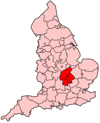
Northamptonshire is a ceremonial county in the East Midlands of England. It is bordered by Leicestershire, Rutland and Lincolnshire to the north, Cambridgeshire to the east, Bedfordshire, Buckinghamshire and Oxfordshire to the south and Warwickshire to the west. Northampton is the largest settlement and the county town.

Bedfordshire is a ceremonial county in the East of England. It is bordered by Northamptonshire to the north, Cambridgeshire to the north-east, Hertfordshire to the south and the south-east, and Buckinghamshire to the west. The largest settlement is Luton (225,262), and Bedford is the county town.
BBC Three Counties Radio is the BBC's local radio station serving the counties of Bedfordshire, Hertfordshire and Buckinghamshire.
The Borough of Wellingborough was a non-metropolitan district and borough in Northamptonshire, England, from 1974 to 2021. It was named after Wellingborough, its main town, but also included surrounding rural areas.

Bedfordshire is an English ceremonial county which lies between approximately 25 miles and 55 miles north of central London.
The Oxford–Cambridge Arc is a notional arc of agricultural and urban land at about 80 kilometres radius of London, in south central England. It runs between the British university cities of Oxford and Cambridge via Milton Keynes and other settlements in Bedfordshire, Buckinghamshire, Cambridgeshire, Northamptonshire, Oxfordshire at the northern rim of the London commuter belt. It is significant only in economic geography, with little physical geography in common.

Milton Keynes Central railway station serves Milton Keynes and surrounding parts of Bedfordshire, Buckinghamshire and Northamptonshire (England). The station is located on the West Coast Main Line about 50 miles (80 km) northwest of London. The station is served by Avanti West Coast intercity services, and by West Midlands Trains regional services.
Sport in Milton Keynes covers a range of professional and amateur sport in the City of Milton Keynes unitary authority area. In 2019, Milton Keynes was officially designated as a European City of Sport for 2020. There are professional teams in football, in motorsport and in ice hockey. The National Badminton Centre, and the Marshall Milton Keynes Athletic Club train professional and amateur athletes. Most other sports feature at amateur level although there are semi-professional teams in rugby union and football among other sports. There is an international-standard karting track owned by Daytona Motorsport.

The University of Bedfordshire is a public research university with campuses in Bedfordshire and Buckinghamshire, England. The university has roots in further and higher education from 1882: it gained university status in 1993 as the University of Luton. The university changed its name to the University of Bedfordshire in 2006, following the merger of the University of Luton with the Bedford campus of De Montfort University.

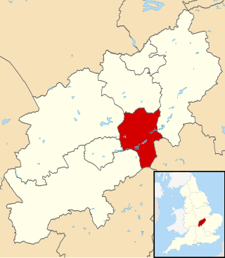
North Northamptonshire is one of two local government districts in Northamptonshire, England. Its council is a unitary authority, being a district council which also performs the functions of a county council. It was created in 2021. The council is based in Corby, the district's largest town. Other notable towns are Kettering, Wellingborough, Rushden, Raunds, Desborough, Rothwell, Irthlingborough, Thrapston and Oundle.

Bedfordshire South was a constituency of the European Parliament located in the United Kingdom, electing one Member of the European Parliament by the first-past-the-post electoral system. Created in 1984 from parts of Bedfordshire and Northamptonshire, it was abolished in 1994 and succeeded by Bedfordshire and Milton Keynes.

United Counties Omnibus was an English bus company, operating in Northamptonshire, Bedfordshire, Buckinghamshire and parts of surrounding counties.

Buses in Milton Keynes are run by a mixture of operators on a network of urban and rural routes in and around the Milton Keynes urban area. These services have a varied history involving five different companies. At the foundation of the 'New City' in 1967 and for some years afterwards, Milton Keynes was served by a rural bus service between and to the pre-existing towns. Apart from a small-scale experimental service, urban buses arrived on the scene with deregulation in 1986. Since April 2010 the core local services have been provided by Arriva Shires & Essex. Long-distance coach services also serve MK, often via the Milton Keynes Coachway located near junction 14 of the M1 motorway.
The South East Midlands Local Enterprise Partnership (SEMLEP) was established in 2011, and was one of 39 Local Enterprise Partnerships set up by the UK Government to drive economic development in England. The SEMLEP geographical region includes 36 enterprise and innovation centres, and five universities. Its board was made up of representatives from the public and private sectors, in addition to skills providers.

A local transport body is a partnership of local authorities in England outside Greater London. There are 38 local transport bodies. They cover similar areas to local enterprise partnerships, but are not permitted to overlap each other. Decision making for major transport infrastructure spending is devolved to these bodies from the Department for Transport. They will receive funding from April 2015.
Healthcare in Bedfordshire is the responsibility of Bedfordshire and Luton Integrated Care Systems.

The Aylesbury Vale is a geographical region in Buckinghamshire, England, which is bounded by the City of Milton Keynes and West Northamptonshire to the north, Central Bedfordshire and the Borough of Dacorum (Hertfordshire) to the east, the Chiltern Hills to the south and South Oxfordshire to the west. It is named after Aylesbury, the county town of Buckinghamshire. Winslow and Buckingham are among the larger towns in the vale.

The East Midlands Rugby Football Union (EMRFU) is a governing body for rugby union in part of The Midlands, England. The union is the constituent body of the Rugby Football Union for the counties of Bedfordshire and Northamptonshire and the Huntingdonshire and Peterborough districts of Cambridgeshire and administers and organises rugby union clubs and competitions in those areas. It also administers the East Midlands county rugby representative teams.
England's Economic Heartland Strategic Alliance is one of seven sub-national transport bodies in England. EEH is a partnership of councils and local enterprise partnerships, stretching from Swindon and Oxfordshire in the west to Cambridgeshire in the east, and from Northamptonshire down to Hertfordshire. The area includes the Oxford-Cambridge Arc, as defined by Government.