Edisto Island is one of South Carolina's Sea Islands, the larger part of which lies in Charleston County, with its southern tip in Colleton County. The town of Edisto Beach is in Colleton County, while the Charleston County part of the island is unincorporated.
Fig Island, also known as 38CH42, is an archaeological site on the Atlantic Coast of South Carolina, consisting of three shell rings. Shell rings are curved shell middens wholly or partially surrounding a clear central area or plaza. The site includes one of the largest and most complex shell rings in North America, and one of the best preserved circular shell rings.
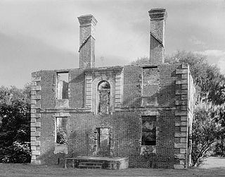
The Paul Hamilton House, commonly referred to as the Brick House Ruins, is the ruin of a 1725 plantation house on Edisto Island, South Carolina, that burned in 1929. It was designated a National Historic Landmark in 1970 for the unusual architecture of the surviving walls, which is partly based on French Huguenot architecture of the period.

The William Seabrook House, also known as the Seabrook is a plantation house built about 1810 on Edisto Island, South Carolina, United States, southwest of Charleston. It is located off Steamboat Landing Road Extension close to Steamboat Creek about 0.7 mi (1.1 km) from Steam Boat Landing. It was named to the National Register of Historic Places on May 6, 1971.

This is a list of the National Register of Historic Places listings in Colleton County, South Carolina.

Botany Bay Plantation Wildlife Management Area is a state preserve on Edisto Island, South Carolina. Botany Bay Plantation was formed in the 1930s from the merger of the Colonial-era Sea Cloud Plantation and Bleak Hall Plantation. In 1977, it was bequeathed to the state as a wildlife preserve; it was opened to the public in 2008. The preserve includes a number of registered historic sites, including two listed in the National Register of Historic Places: a set of three surviving 1840s outbuildings from Bleak Hall Plantation, and the prehistoric Fig Island shell rings.
Cassina Point was built in 1847 for Carolina Lafayette Seabrook and her husband, James Hopkinson. Carolina Seabrook was the daughter of wealthy Edisto Island planter William Seabrook. William Seabrook had hosted the General Lafayette in 1825 at his nearby home at the time of Carolina's birth. Seabrook gave Lafayette the honor of naming the newborn child, and the general selected Carolina and Lafayette. When Carolina Seabrook married James Hopkinson, they built Cassina Point on the land given to them by William Seabrook.
Peters Point Plantation is a historic structure located on Edisto Island, South Carolina. It was built by Isaac Jenkins Mikell in 1840 at the intersection of St. Pierre's Creek and Fishing Creek. It is located on the site General Lafayette used as a departure point from Edisto Island in 1826 during his southern tour.
Fennell Hill, also known as Cox Site and Milberry Site, is a historic archaeological site located near Peeples, Allendale County, South Carolina. It is a formative shell midden on the Savannah River measuring about 96 meters long by about 48 meters in width. The midden contains large quantities of fiber-tempered and Thom's Creek pottery—both examples of the earliest pottery found in the southeast.

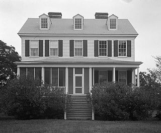
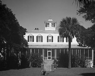
Seaside Plantation House, also known as Locksley Hall, is a historic plantation house located at Edisto Island, Colleton County, South Carolina. It was built about 1810, and is a 2+1⁄2-story, Federal style brick dwelling with a gable roof. The house is one room deep with a long porch across the southeast elevation and sits on a raised basement. The central portion of the house is stuccoed brick with frame additions on the first floor.
Blair Mound is a historic archaeological site located near Winnsboro, Fairfield County, South Carolina. Blair Mound is an earthen mound structure in the form of a low, oval hummock. It measures approximately 75 by 50 yards and is just over 5 feet (1.5 m) high, with evidence of leveling for agricultural development.
Minim Island Shell Midden (38GE46) is a historic midden and archaeological site located near Georgetown, Georgetown County, South Carolina. The site consists of prehistoric midden deposits of shellfish remains, floral and faunal remains, and interred human burials. Cultural materials in the form of ceramics and lithics occur throughout the midden. These deposits are concentrated for a distance of about 100 feet along the shoreline of the Intracoastal Waterway.
Buzzard's Island Site is a historic mound located near Mount Pleasant, Charleston County, South Carolina. It is one of 20 or more prehistoric shell rings located from the central coast of South Carolina to the central coast of Georgia. On average, it measures 178 feet in diameter and stands 3 feet high. The midden is largely composed of oyster shell.
Seaside School, also known as Seaside Colored School, is a historic school building for African-American children located at Edisto Island, Charleston County, South Carolina. It was built about 1931, and is a one-story, two-room, rectangular frame building. It sits on a low brick pier foundation and has weatherboard exterior siding. The school has been vacant since 1954, except for brief periods of residential tenant occupancy. It is one of only three remaining historic schools on Edisto Island.
Paul Grimball House Ruins is a historic archaeological site located at Edisto Island, Charleston County, South Carolina. The stuccoed tabby house was built about 1682. In August 1686, the house was occupied, sacked, and possibly burned by the Spanish on a raid up the North Edisto River. The remains consist of a 12 feet high corner portion of a stucco covered tabby wall.
Hephzibah Jenkins Townsend's Tabby Oven Ruins is a historic archaeological site located at Edisto Island, Charleston County, South Carolina. The remains represent what was essentially a commercial bakery.

Alexander Bache U.S. Coast Survey Line is a historic geodetic survey line located at Edisto Island, Charleston County, South Carolina. This base line was surveyed by Alexander Dallas Bache and his assistants during January 1850. They buried granite blocks at each endpoint and then placed a granite monument on top of each block.

Wescott Road, also known as Westcoat Road, is a historic road located at Edisto Island, Charleston County, South Carolina. It represents the last undisturbed remnants of the main road on Edisto Island, and is an oak-lined dirt road approximately 2/5 mile in distance. The road was established in the Colonial era. This section was isolated when S.C. Highway 174 was straightened and paved about 1940.

Oak Island, also known as the William Seabrook, Jr. House, is a historic plantation house located at Edisto Island, Charleston County, South Carolina. It was built about 1828–1831, and is a 2+1⁄2-story, five bay, rectangular, central-hall, frame, weatherboard-clad residence with a projecting two-story rear pavilion. It features two, massive, interior chimneys with heavily corbelled caps and a one-story, wraparound hipped roof porch.
Sunnyside, also known as the Townsend Mikell House, is a historic plantation house located at Edisto Island, Charleston County, South Carolina. The main house was built about 1875, and is a 1+1⁄2-story, rectangular, frame, weatherboard-clad residence. It features a mansard roof topped by a cupola and one-story, hipped roof wraparound porch. Also on the property are the tabby foundation of a cotton gin; two small, rectangular, one-story, gable roof, weatherboard-clad outbuildings; a 1+1⁄2-story barn; and the Sunnyside Plantation Foreman's House. The Foreman's House is a two-story, weatherboard-clad, frame residence built about 1867.


