Sprotbrough Flash

Last updated

Sprotbrough Flash
Sprotbrough Flash - geograph.org.uk - 116967.jpg
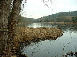
The eponymous body of water
Sprotborough flash.png
Sprotbrough Flash
TypeNature reserve
Location South Yorkshire
Nearest city Doncaster
OS grid SE 536 013
Coordinates 53°30′06″N1°11′41″W / 53.5016°N 1.1948°W / 53.5016; -1.1948
Area28 ha
Operated byYorkshire Wildlife Trust
Website http://www.ywt.org.uk/reserves/sprotbrough-flash-nature-reserve

Sprotbrough Flash is a nature reserve south of Sprotbrough near Doncaster, South Yorkshire, on the north bank of the River Don. It is named after its main feature, a long, water-filled depression parallel to the river. [1] The reserve is managed by the Yorkshire Wildlife Trust. It overlaps with Sprotbrough Gorge, a Site of Special Scientific Interest. [2] The size of the protected area is 28 hectares (0.28 square kilometers). The Trans Pennine Trail passes through the area.

Contents

History

Two hundred and eighty million years ago, during the Permian period, dolomite (magnesium limestone) formed here. This has been mined since the mid-19th century. [3] [4] Mining has since stopped and wildlife has returned to this area. The original quarry can still be seen opposite the River Don, adjacent to the Sprotbrough Flash lake. [5]

Worthy of note, the woolly rhinoceros [6] lived in this area in the Pleistocene. Bones from this creature have been discovered here. [7]

The long lake from which the name of the reserve is derived is the result of subsidence caused by the collapse of old coal mines. [8]

Wildlife

Observation screen on the lake Heron screen overlooking Sprotborough flash. - geograph.org.uk - 536092.jpg
Observation screen on the lake

Sightings of a range of bird and land life have been noted here. [9] The fauna includes common kingfishers, brown hare, grass snakes, Eurasian bitterns, ruddy darters, and the great crested grebe. Plant life includes common twayblade, common spotted orchid, spindle, small leaved lime, woodruff, greater stitchwort, sanicle, and the early purple orchid.

Related Research Articles

Riddlesden Human Settlement in West Yorkshire, England

Riddlesden is a suburb of Keighley in the county of West Yorkshire, England and on the Leeds and Liverpool Canal.

Yorkshire Wildlife Trust

The Yorkshire Wildlife Trust is a charitable non-governmental organisation, one of the UK's 46 county-based Wildlife Trusts. It's focus is nature conservation and it works to achieve a nature-rich Yorkshire with healthy and resilient ecosystems that support both Yorkshire's wildlife and its people.

RSPB Dearne Valley Old Moor English wetlands nature reserve

RSPB Dearne Valley Old Moor is an 89-hectare (220-acre) wetlands nature reserve in the Dearne Valley near Barnsley, South Yorkshire, run by the Royal Society for the Protection of Birds (RSPB). It lies on the junction of the A633 and A6195 roads and is bordered by the Trans Pennine Trail long-distance path. Following the end of coal mining locally, the Dearne Valley had become a derelict post-industrial area, and the removal of soil to cover an adjacent polluted site enabled the creation of the wetlands at Old Moor.

Leigh Woods National Nature Reserve National nature reserve near Bristol, England

Leigh Woods is a 2-square-kilometre (0.77 sq mi) area of woodland on the south-west side of the Avon Gorge, close to the Clifton Suspension Bridge, within North Somerset opposite the English city of Bristol and north of the Ashton Court estate, of which it formed a part. Stokeleigh Camp, a hillfort thought to have been occupied from the third century BC to the first century AD and possibly also in the Middle Ages, lies within the reserve on the edge of the Nightingale Valley. On the bank of the Avon, within the reserve, are quarries for limestone and celestine which were worked in the 18th and 19th centuries are now derelict.

Brownes Folly Site of a tower with the same name

Brown's Folly or Brown's Folly is a folly tower sitting within a 39.9 hectare biological and geological Site of Special Scientific Interest (SSSI) near the village of Bathford in Somerset, notified in 1974: the site itself is known as the Farleigh Down Stone Quarry, and is managed as a nature reserve by the Avon Wildlife Trust (AWT). The tower was built in 1848 and is a Grade II listed building.

River Wiske River in North Yorkshire, England

The River Wiske is a tributary of the River Swale in Yorkshire, England. The Wiske gives its name to several villages it passes through. The name Wiske is derived from an Old English word wisca meaning a water meadow. It was once known as the Foulbroke, a name for which some writers commented that it was well deserved.

Cheddar Complex Site of Special Scientific Interest in Somerset, England

The Cheddar Complex is a 441.3 hectare biological Site of Special Scientific Interest near Cheddar around the Cheddar Gorge and north east to Charterhouse in the Mendip Hills, Somerset, England, notified in 1952.

River Allen, Northumberland River in Northumberland, England

The River Allen is a river in the English county of Northumberland. The river has its sources in the hills of the Northern Pennines, and is formed by the confluence of the East and West Allen rivers. The Allen is itself, a tributary of the River Tyne. The Allen was formerly very polluted from mining activity upstream, but remediation schemes have been implemented to allow the water quality to improve.

Levitt Hagg Abandoned hamlet in South Yorkshire, England

Levitt Hagg is an abandoned hamlet in South Yorkshire, located approximately two miles southwest of Doncaster and near Conisbrough Castle. Limestone began to be quarried at the site in ancient times. Levitt Hagg was also the site, along with nearby environs in the Don Gorge, of ancient woodlands rich in yew trees. The old settlement of Levitt Hagg was removed in the 1950s.

There are several nature reserves in the surroundings of Nailsea, North Somerset, England, which is located at 51°25′55″N2°45′49″W.

Stenders Quarry Biological and geological Site of Special Scientific Interest in Gloucestershire, England

Stenders Quarry is a 2.8-hectare (6.9-acre) biological and geological Site of Special Scientific Interest in the Forest of Dean, Gloucestershire, England, notified in 1966 and renotified in 1990. The site is designated as an SSSI for its important geological features, although there is also a diversity of plants and animals recorded.

Box Farm Meadows SSSI Biological Site of Special Scientific Interest in Gloucestershire, England

Box Farm Meadows is a 8.3-hectare (21-acre) biological Site of Special Scientific Interest in Gloucestershire, notified in 1985. This was formerly known as Balls Green Pastures. The reserve is situated at the southern edge of Box village and one mile east of Nailsworth.

Lower Wye Gorge is a 65-hectare (160-acre) biological and geological Site of Special Scientific Interest in Gloucestershire, notified in 1954 and renotified 1987. The site includes two Gloucestershire Wildlife Trust nature reserves being Ban-y-gor Wood and Lancaut. The Natural England citation states a revision for Lancaut inclusion.

Cutsdean Quarry Nature reserve in Gloucestershire, England

Cutsdean Quarry is a 0.83-hectare (2.1-acre) nature reserve in Gloucestershire. The site is listed in the 'Cotswold District' Local Plan 2001-2011 as a Key Wildlife Site (KWS).

St Aidan's is a 400-hectare (990-acre) nature park located between Leeds and Castleford in West Yorkshire, England. The land was formerly an opencast coal mining area that was flooded in 1988, after the riverbank collapsed. Repairs and remediation required its own act in Parliament to allow the necessary works to go ahead. Mining ceased at St Aidan's in 2002.

Flash (lake)

A flash is a body of water that forms where the land below it has subsided. Whilst these are mostly found in areas where mining has taken place, some can occur naturally. Collectively they are known as Flashes

Quarry Moor Site of Special Scientific Interest in North Yorkshire, England

Quarry Moor is a Site of Special Scientific Interest, or SSSI, at the south edge of Ripon, North Yorkshire, England, and adjacent to the A61 road. It contains an outcrop of Magnesian Limestone, exposed by former quarrying. 255 million years ago this limestone was the peripheral sediment of a tropical sea. The land was donated in 1945 to the people of Ripon by the town's mayor, Alderman Thomas Fowler Spence, a varnish manufacturer. The land was notified as an SSSI in 1986 because its calcareous grassland supported a large diversity of plant species. The site features a Schedule 8 protected plant, thistle broomrape. The land is protected as a nature reserve, and it is also managed as a recreational area. Therefore, its calcareous grass area is fenced off for protection and study, but it also contains a car park, information signs, a children's play area, accessible paths, benches, and dog waste bins.

<i>Orobanche reticulata</i> Species of flowering plant

Orobanche reticulata is a species of broomrape known by the common name thistle broomrape. It is a parasitic plant whose host is normally the creeping thistle. It is native to the lowlands of Western Europe and Central Asia, but in the United Kingdom it is a rare and protected plant, growing only in Yorkshire, on grassland sites such as Quarry Moor.

Chee Dale Valley in the Derbyshire Peak District, England

Chee Dale is a steep-sided gorge on the River Wye near Buxton, Derbyshire, in the Peak District of England.

References

  1. "Sprotbrough Gorge" (PDF). 24 March 1988.
  2. "Sprotbrough Gorge SSSI". Natural England.
  3. "Limestone/dolomite mining sites by region UK 2014 | Statistics". Statista. Retrieved 21 April 2017.
  4. "Extractive Zone | South Yorkshire Historic Environment Characterisation". sytimescapes.org.uk. Retrieved 21 April 2017.
  5. "Sprotbrough Flash". Local Explorer - Adventure Just Beyond Your Door. Local Explorer. p. 1. Retrieved 2 May 2017.
  6. "Extinct Woolly Rhino". International Rhino Foundation. Retrieved 21 April 2017.
  7. "Sprotbrough Flash Nature Reserve Yorkshire Wildlife Trust | Love Yorkshire, Love Wildlife". www.ywt.org.uk. Retrieved 21 August 2017.
  8. Nigel Homer (4 February 2006). "Sprotbrough Flash". Geograph Britain and Ireland.
  9. "Sprotbrough Flash Nature Reserve Yorkshire Wildlife Trust | Love Yorkshire, Love Wildlife". www.ywt.org.uk. Retrieved 21 April 2017.