
Spynie Canal is a canal in Moray, Scotland, which lies between Elgin and Lossiemouth. It drains into the River Lossie near its mouth at Lossiemouth. [1]
Spynie Canal is a canal in Moray, Scotland, which lies between Elgin and Lossiemouth. It drains into the River Lossie near its mouth at Lossiemouth. [1]
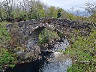
Spynie Canal was created as the culmination of attempts to drain Loch Spynie (which survives as a small loch) and the low-lying areas between Spynie Palace and Lossiemouth, the surplus water flowing through sluice gates at Lossiemouth. Thomas Telford was consulted in 1808 and the contractor for the work 1808–11 was a Mr Hughes, who had worked on the Caledonian Canal. The unprecedented floods of 1829 caused considerable damage and subsequently dykes were thrown up along the canal's banks. [2] [3]

The Caledonian Canal connects the Scottish east coast at Inverness with the west coast at Corpach near Fort William in Scotland. The canal was constructed in the early nineteenth century by Scottish engineer Thomas Telford.

Lossiemouth is a town in Moray, Scotland. Originally the port belonging to Elgin, it became an important fishing town. Although there has been over 1,000 years of settlement in the area, the present day town was formed over the past 250 years and consists of four separate communities that eventually merged into one. From 1890 to 1975, it was a police burgh as Lossiemouth and Branderburgh.

The Great Glen, also known as Glen Albyn or Glen More, is a glen in Scotland running for 62 miles (100 km) from Inverness on the edge of the Moray Firth, in an approximately straight line to Fort William at the head of Loch Linnhe. It follows a geological fault known as the Great Glen Fault, and bisects the Scottish Highlands into the Grampian Mountains to the southeast and the Northwest Highlands to the northwest.

Eilean Bàn is a six-acre (2.4 ha) island between Kyle of Lochalsh and the Isle of Skye, in the historic county of Ross and Cromarty in the Highland local government area. The Skye Bridge uses the island as a stepping-stone as it crosses the mouth of Loch Alsh from the mainland to Skye.

The Sound of Jura is a Sound in Argyll and Bute, Scotland. It is one of the several Sounds of Scotland. It is to the east of the island of Jura and the west of Knapdale, in the north of the Kintyre Peninsula, of the Scottish mainland. Lochs that lead to the sound include Loch Sween, and Loch Killisport. It is not to be confused with the Sound of Islay, which lies between Jura and Islay. Most of Jura's small population lives on the east coast, overlooking the sound.
Gogarloch is a residential area within South Gyle, Edinburgh, Scotland. It lies near South Gyle railway station and South Gyle Broadway, 4+1⁄2 miles (7.2 km) west of the city centre. Corstorphine and Wester Broom are nearby.

Maybury is an area on the western edge of Edinburgh, Scotland, near South Gyle and Ingliston, named after the road, which is itself named after the civil engineer Sir Henry Maybury (1864–1943). In 2021, residents have been undertaking community clean ups to clear the foot paths along the road. The area is residential in the north east/east and commercial in the south and west and The Gyle Shopping Centre is nearby. In 2021, there was a consultation about creating a Primary School and Health Centre in Maybury.

Holm is a small residential area in the south of the city of Inverness, Scotland. The area lies east of the River Ness.

Spynie was a seaport, burgh and ancient parish in Moray, Scotland, that survives as a small hamlet and civil parish. It is the location of the ruins of Spynie Palace, which was the principal residence of the Bishops of Moray between the 12th and 17th centuries, and the churchyard of Holy Trinity Church, Spynie, which served as the cathedral of the Diocese of Moray between 1207 and 1224.
Lossiemouth High School is a secondary school in the coastal town of Lossiemouth, Moray, Scotland.
Whitebridge is a small village on the southwest side of Loch Ness in northern Scotland.
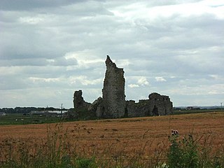
Inverallochy Castle is a ruined courtyard castle, near the village of Inverallochy in the Buchan area of North-East Scotland, dating to 1504. It lies 0.5 miles (0.80 km) south of Cairnbulg Castle, near Fraserburgh, and formerly stood beside the now-drained Loch of Inverallochy. It was described by W. Douglas Simpson as one of the nine castles of the Knuckle, referring to the rocky headland of North-East Aberdeenshire.

Kinneddar is a small settlement on the outskirts of Lossiemouth in Moray, Scotland, near the main entrance to RAF Lossiemouth. Long predating the modern town of Lossiemouth, Kinneddar was a major monastic centre for the Pictish kingdom of Fortriu from the 6th or 7th centuries, and the source of the important collection of Pictish stones called the Drainie Carved Stones. The Kirk of Kinneddar was the cathedral of the Diocese of Moray between 1187 and 1208, and remained an important centre of diocesan administration and residence of the Bishop of Moray through the 13th and 14th centuries.

Milton is a village in Glenurquhart, to the west of the village of Drumnadrochit, in the Highland council area of Scotland. It lies on the north side of the River Enrick, next to the A831 road.
The Inverarnan Canal was a short length of canal terminating at Garbal, close to the hamlet of Inverarnan, Scotland. This waterway once linked the old coaching inn, now the Drovers Inn, at Inverarnan, on the Allt Arnan Burn to the River Falloch and passengers could continue southward to Loch Lomond and finally to Balloch. From Inverarnan stagecoaches ran to various destinations in the north of Scotland.
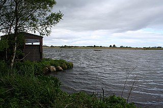
Loch Spynie is a small loch located between the towns of Elgin and Lossiemouth in Moray, Scotland. Close to Spynie Palace, the ancient home of the bishops of Moray, it is an important wildlife habitat which is protected as a Ramsar Site.

The Sculptor's Cave is a sandstone cave on the south shore of the Moray Firth in Scotland, near the small settlement of Covesea, between Burghead and Lossiemouth in Moray. It is named after the Pictish carvings incised on the walls of the cave near its entrances. There are seven groups of carvings dating from the 6th or 7th century, including fish, crescent and V-rod, pentacle, triple oval, step, rectangle, disc and rectangle, flower, and mirror patterns, some very basic but others more sophisticated.
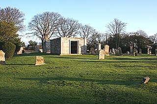
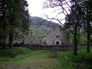
Holy Trinity Church, Spynie was until 1735 the parish church of Spynie, Moray in north-east Scotland, and served as the cathedral of the Diocese of Moray between 1207 and 1224.
Kintrae is a hamlet in the parish of Spynie, Moray, Scotland, originally located on the southern shore of Loch Spynie. The name is Celtic, meaning “the top of the tide”.
Kirkmichael is a parish in the council area of Moray, Scotland. It lies south of Ballindalloch and includes the Tomintoul Distillery.
57°41′14″N3°16′41″W / 57.68713°N 3.27813°W
| | This United Kingdom canal-related article is a stub. You can help Wikipedia by expanding it. |
| | This Moray location article is a stub. You can help Wikipedia by expanding it. |