St. Francisville, Missouri | |
|---|---|
 | |
| Coordinates: 40°26′59″N91°34′19″W / 40.44972°N 91.57194°W | |
| Country | United States |
| State | Missouri |
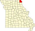
| County | Clark |
| Area | |
• Total | 1.91 sq mi (4.95 km2) |
| • Land | 1.86 sq mi (4.81 km2) |
| • Water | 0.05 sq mi (0.14 km2) |
| Elevation | 633 ft (193 m) |
| Population (2020) | |
• Total | 137 |
| • Density | 73.70/sq mi (28.46/km2) |
| ZIP code | 63472 [3] |
| Area code | 660 |
| FIPS code | 29-64244 |
| GNIS feature ID | 2587112 [2] |
St. Francisville or Saint Francisville is an unincorporated community and census-designated place in northeast Clark County, Missouri, United States. [2] As of the 2020 census, its population was 137. [4]
Contents
The community is on Missouri Route B four miles north of Wayland. The Des Moines River and the Missouri-Iowa border are one-half mile north of the community. [5] It is the oldest settlement in Clark County, Missouri.