
Travis County is located in Central Texas. As of the 2020 census, the population was 1,290,188. It is the fifth-most populous county in Texas. Its county seat and most populous city is Austin, the capital of Texas. The county was established in 1840 and is named in honor of William Barret Travis, the commander of the Republic of Texas forces at the Battle of the Alamo. Travis County is part of the Austin–Round Rock–Georgetown Metropolitan Statistical Area. It is located along the Balcones Fault, the boundary between the Edwards Plateau to the west and the Blackland Prairie to the east.

Fayette County is a county located in the U.S. state of Texas. As of the 2020 census, the population was 24,435. Its county seat is La Grange. The county was created in 1837 and organized the next year.

Caldwell County is a county located in the U.S. state of Texas. As of the 2020 census, its population was 45,883. Its county seat is Lockhart. The county was founded in 1848 and named after Mathew Caldwell, a ranger captain who fought in the Battle of Plum Creek against the Comanches and against Santa Anna's armies during the Texas Revolution. Caldwell was also a signer of the Texas Declaration of Independence.
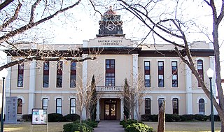
Bastrop County is located in the U.S. state of Texas. It is in Central Texas and its county seat is Bastrop.

Bastrop is a city and the county seat of Bastrop County, Texas, United States. The population was 9,688 according to the 2020 census. It is located about 30 mi (48 km) southeast of Austin and is part of the Greater Austin metropolitan area.

Sugar Land is the largest city in Fort Bend County, Texas, United States, located in the southwestern part of the Houston–The Woodlands–Sugar Land metropolitan area. Located about 19 miles (31 km) southwest of downtown Houston, Sugar Land is a populous suburban municipality centered around the junction of Texas State Highway 6 and Interstate 69/U.S. Route 59.

Crosby is a census-designated place in Harris County, Texas, United States. The population was 3,417 at the 2020 census.

The Austin–Round Rock–San Marcos metropolitan statistical area, or Greater Austin, is a five-county metropolitan area in the U.S. state of Texas, as defined by the Office of Management and Budget. The metropolitan area is situated in Central Texas on the western edge of the American South and on the eastern edge of the American Southwest, and borders Greater San Antonio to the south.
Stoneham is an unincorporated community in Grimes County, Texas, United States. The town was once a part of a colony operated by Stephen F. Austin and by 1900, the population grew to 250. Although a ghost town by 1970, the town has since grown in population.
Saint John Colony is an unincorporated community in Caldwell County, Texas, United States. According to the Handbook of Texas, the community had a population of 150 in 2000. It is located within the Greater Austin metropolitan area.

Travis County has had two locations named Montopolis. The first was during the Republic of Texas period north of the Colorado River. The second is today's Montopolis neighborhood in Austin, Texas south of the river. Located southeast of the city's urban core, today's neighborhood is in ZIP code 78741. Montopolis is bounded by Lake Lady Bird on the north, by Grove Street and the Pleasant Valley neighborhood on the west, to the south by Texas State Highway 71, and by U.S. Route 183 on the east. The southeast corner abuts Austin-Bergstrom International Airport. Montopolis is in City Council District 3.
Nigton is an unincorporated community in Trinity County, Texas, United States. In 2000, the population was 87. It is located within the Huntsville, Texas micropolitan area.

String Prairie is an unincorporated community in Bastrop County, Texas, United States. According to the Handbook of Texas, the community had a population of 125 in 2000. It is located within the Greater Austin metropolitan area.
Hills Prairie, or Hill's Prairie, is an unincorporated community in Bastrop County, Texas, United States. According to the Handbook of Texas, the community had a population of 50 in 2000. It is located within the Greater Austin metropolitan area.
Watterson is an unincorporated community in Bastrop County, Texas, United States. It is located within the Greater Austin metropolitan area.
Salem is an unincorporated community in Bastrop County, Texas, United States. The town is one of 17 communities named Salem in the state. It is located within the Greater Austin metropolitan area.
McDuff is a ghost town in Bastrop County, Texas, United States. The community was located eight miles southwest of Elgin, 12 miles northwest of Bastrop, and 25 miles east of Austin. It was on an old stage mail route from Bastrop to Austin. Today, the town site would correspond roughly with the intersection of Farm to Market Road 969 and Upper Elgin River Road.
Oak Hill is a ghost town in Bastrop County, Texas, United States. It is located four miles southwest of McDade, 12 miles southeast of Elgin, 13 miles northeast of Bastrop, and 37 miles southeast of Austin on the old Bastrop-McDade Road.
Butler is an unincorporated community in Bastrop County, Texas, United States. It is located within the Greater Austin metropolitan area.

Peyton is an unincorporated community in Blanco County, in the U.S. state of Texas. According to the Handbook of Texas, the community had a population of 30 in 2000.


