String Prairie, Texas

Last updated

String Prairie, Texas
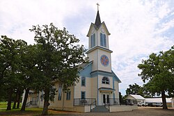
Saint Mary Church String Prairie Texas 2024.jpg
Saint Mary of the Assumption Church
USA Texas location map.svg
Red pog.svg
String Prairie
Usa edcp location map.svg
Red pog.svg
String Prairie
Coordinates: 29°53′09″N97°20′49″W / 29.88583°N 97.34694°W / 29.88583; -97.34694
Country United States
State Texas
County Bastrop
Elevation
[1]
505 ft (154 m)
Time zone UTC-6 (Central (CST))
  Summer (DST) UTC-5 (CDT)
Area code(s) 512 & 737
GNIS feature ID1369285 [1]

String Prairie is an unincorporated community in Bastrop County, Texas, United States. [1] According to the Handbook of Texas, the community had a population of 125 in 2000. It is located within the Greater Austin metropolitan area.

Contents

History

Settlement of String Prairie began before the Civil War. A post office was established at String Prairie in 1886 and remained in operation until 1929, with George Zimmerman as the first postmaster. By 1890, the town had a general store, a cotton gin, and a pharmacist. From 1890 to 1914, String Prairie's population rose from 25 to 400. With growth, the community added new businesses, including three blacksmith shops, grocery and drug stores, as well as a millinery establishment. [2] Then and now, Saint Mary of the Assumption Church has been a hub of social life. [3]

The population declined through the remainder of the decade and by 1930, had returned to only 25 individuals. However, following World War II, it increased to 50, in the late 1940s, and then to 75, in the late 1960s. Over the next 40 years, it grew to 125. [4]

Geography

Located on Texas State Highway 304, the town is 5 miles (8.0 km) southwest of Rosanky and 45 miles (72 km) southeast of Austin. It is also located 20 mi (32 km) west of Bastrop. [4]

Education

In 1924, residents built a one-teacher school using funds acquired through a fifty-cent school tax. [2] Today, the community is served by the Smithville Independent School District.

Related Research Articles

<span class="mw-page-title-main">Travis County, Texas</span> County in Texas, U.S.

Travis County is located in Central Texas. As of the 2020 census, the population was 1,290,188. It is the fifth-most populous county in Texas. Its county seat and most populous city is Austin, the capital of Texas. The county was established in 1840 and is named in honor of William Barret Travis, the commander of the Republic of Texas forces at the Battle of the Alamo. Travis County is part of the Austin–Round Rock–Georgetown Metropolitan Statistical Area. It is located along the Balcones Fault, the boundary between the Edwards Plateau to the west and the Blackland Prairie to the east.

<span class="mw-page-title-main">Caldwell County, Texas</span> County in Texas, United States

Caldwell County is a county located in the U.S. state of Texas. As of the 2020 census, its population was 45,883. Its county seat is Lockhart. The county was founded in 1848 and named after Mathew Caldwell, a ranger captain who fought in the Battle of Plum Creek against the Comanches and against Santa Anna's armies during the Texas Revolution. Caldwell was also a signer of the Texas Declaration of Independence.

<span class="mw-page-title-main">Bastrop County, Texas</span> County in Texas, United States

Bastrop County is located in the U.S. state of Texas. It is in Central Texas and its county seat is Bastrop.

<span class="mw-page-title-main">Bastrop, Texas</span> City in Texas, United States

Bastrop is a city and the county seat of Bastrop County, Texas, United States. The population was 9,688 according to the 2020 census. It is located about 30 mi (48 km) southeast of Austin and is part of the Greater Austin metropolitan area.

<span class="mw-page-title-main">Smithville, Texas</span> City in Texas, United States

Smithville is a city in Bastrop County, Texas, United States, near the Colorado River. The population was 3,922 at the 2020 census.

<span class="mw-page-title-main">Fayetteville, Texas</span> City in Texas, United States

Fayetteville is a city in Fayette County, Texas, United States. The population was 246 at the 2020 census.

<span class="mw-page-title-main">Elgin, Texas</span> City in Texas, United States

Elgin is a city in Bastrop County in the U.S. state of Texas. The population was 9,784 at the 2020 census. Elgin is also known as the Sausage Capital of Texas and the Brick Capital of the Southwest, due to the presence of three operating brickyards in the mid-20th century.

<span class="mw-page-title-main">Greater Austin</span> Metropolitan Statistical Area in Texas, United States

The Austin–Round Rock–San Marcos metropolitan statistical area, or Greater Austin, is a five-county metropolitan area in the U.S. state of Texas, as defined by the Office of Management and Budget. The metropolitan area is situated in Central Texas on the western edge of the American South and on the eastern edge of the American Southwest, and borders Greater San Antonio to the south.

<span class="mw-page-title-main">Cedar Creek, Texas</span> Unincorporated community in Bastrop County, Texas, United States

Cedar Creek is an census-designated place (CDP) in Bastrop County, Texas, United States. It is located about 11 miles (18 km) west of the city of Bastrop. The community takes its name from Cedar Creek, a tributary of the Colorado River that is close to the area. Cedar Creek is home to McKinney Roughs Nature Park, which features natural landscapes and an archaeological site.

Jeddo is an unincorporated community in Bastrop County, Texas, United States. According to the Handbook of Texas, the community had a population of 75 in 2000. It is located within the Greater Austin metropolitan area.

<span class="mw-page-title-main">Bateman, Texas</span> Unincorporated community in Texas, United States

Bateman is an unincorporated community in Bastrop County, Texas, United States. It is located within the Greater Austin metropolitan area.

<span class="mw-page-title-main">Montopolis, Austin, Texas</span> Neighborhood in Austin, Texas, United States

Travis County has had two locations named Montopolis. The first was during the Republic of Texas period north of the Colorado River. The second is today's Montopolis neighborhood in Austin, Texas south of the river. Located southeast of the city's urban core, today's neighborhood is in ZIP code 78741. Montopolis is bounded by Lake Lady Bird on the north, by Grove Street and the Pleasant Valley neighborhood on the west, to the south by Texas State Highway 71, and by U.S. Route 183 on the east. The southeast corner abuts Austin-Bergstrom International Airport. Montopolis is in City Council District 3.

<span class="mw-page-title-main">Hills Prairie, Texas</span> Unincorporated community in Texas, United States

Hills Prairie, or Hill's Prairie, is an unincorporated community in Bastrop County, Texas, United States. According to the Handbook of Texas, the community had a population of 50 in 2000. It is located within the Greater Austin metropolitan area.

Watterson is an unincorporated community in Bastrop County, Texas, United States. It is located within the Greater Austin metropolitan area.

Grassyville is a ghost town located in Bastrop County, Texas, United States. The community was founded in the northeastern corner of the county, near the intersection of Farm to Market Road 2104 and Farm to Market Road 2239, six miles south of Paige, 14 miles east of Bastrop, and 50 miles east of Austin.

Salem is an unincorporated community in Bastrop County, Texas, United States. The town is one of 17 communities named Salem in the state. It is located within the Greater Austin metropolitan area.

McDuff is a ghost town in Bastrop County, Texas, United States. The community was located eight miles southwest of Elgin, 12 miles northwest of Bastrop, and 25 miles east of Austin. It was on an old stage mail route from Bastrop to Austin. Today, the town site would correspond roughly with the intersection of Farm to Market Road 969 and Upper Elgin River Road.

Oak Hill is a ghost town in Bastrop County, Texas, United States. It is located four miles southwest of McDade, 12 miles southeast of Elgin, 13 miles northeast of Bastrop, and 37 miles southeast of Austin on the old Bastrop-McDade Road.

Butler is an unincorporated community in Bastrop County, Texas, United States. It is located within the Greater Austin metropolitan area.

<span class="mw-page-title-main">St. Mary's Colony, Texas</span> Unincorporated community in Texas, United States

St. Mary's Colony is an unincorporated community in Bastrop County, Texas, United States. It is located in the far western corner of the county, 17 miles west of the town of Bastrop on State Highway 21.

References

  1. 1 2 3 U.S. Geological Survey Geographic Names Information System: String Prairie, Texas
  2. 1 2 Mitchell Marks, Paula. "String Prairie, TX (Bastrop County)". Texas State Historical Association. Retrieved August 13, 2018.
  3. String Prairie, Texas, Deb Dahlberg Rowland-Career Realtor in South Central Texas, http://www.debdahlbergrowland.com/2014/07/string-prairie-texas/
  4. 1 2 "String Prairie, Texas". Texas Escapes. Retrieved August 13, 2018.