
St Erth Praze is a hamlet in west Cornwall, England, United Kingdom. It is on the B3302 road east of St Erth. [1]
St Erth Praze is a hamlet in west Cornwall, England, United Kingdom. It is on the B3302 road east of St Erth. [1]
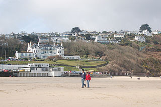
Carbis Bay is a seaside resort and village in Cornwall, England. It lies 1 mile (1.6 km) southeast of St Ives, on the western coast of St Ives Bay, on the Atlantic coast. The South West Coast Path passes above the beach.

St Erth is a civil parish and village in Cornwall, England, United Kingdom.

The British Rail Class 122 diesel mechanical multiple units were built by Gloucester RC&W in 1958. Twenty single-car, double-ended driving motor vehicles, nicknamed "Bubble Cars", were built, numbered 55000–55019. These were supplemented by nine single-ended trailer vehicles, numbered 56291–56299.

The St Ives Bay Line is a 4.25 miles (6.84 km) railway line from St Erth to St Ives in Cornwall, England, United Kingdom. It was opened in 1877, the last new 7 ft broad gauge passenger railway to be constructed in the country. Converted to standard gauge in 1892, it continues to operate as a community railway, carrying tourists as well as local passengers. It has five stations including the junction with the Cornish Main Line at St Erth.

Gwinear–Gwithian is a coastal civil parish in west Cornwall, England, United Kingdom. It includes the villages of Connor Downs, Gwinear, Gwithian, Reawla and Rosewarne. The parish is situated approximately two miles (3 km) east of Hayle two miles (3 km) west of Camborne.

St Erth railway station is a Grade II listed station situated at Rose-an-Grouse in Cornwall, United Kingdom. It serves the nearby village of St Erth, which is about 0.75 miles (1.21 km) away, and is the junction for the St Ives Bay Line to St Ives. The station is 320 miles 78 chains from the zero point at London Paddington measured via Box and Plymouth Millbay.

Trelissick is a house and garden in the ownership of the National Trust at Feock, near Truro, Cornwall, England. It is located on the B3289 road, just west of King Harry Ferry, and overlooks the estuary known as Carrick Roads. It lies within the Cornwall Area of Outstanding Natural Beauty (AONB). Almost a third of Cornwall has AONB designation.

St Ives railway station is a railway station which serves the coastal town of St Ives, Cornwall, England. It was opened in 1877 as the terminus of the last new broad gauge passenger railway to be constructed in the country. Converted to standard gauge in 1892, it is today served by Great Western Railway services on the St Ives Bay Line from St Erth.

Lelant Saltings railway station was opened on 27 May 1978 to provide a park and ride facility for visitors to St Ives, Cornwall, England. It is situated on the A3074 road close to the junction with the A30 near the foot of the hill up to Lelant village. The park and ride facility closed in June 2019, replaced by a new one at nearby St Erth railway station, but the Saltings station remains open with a very limited service of trains.
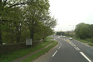
Canon's Town or Canonstown is a hamlet in west Cornwall, England, UK, situated on the A30 road in the civil parish of Ludgvan, between Penzance and Hayle. It is southwest of St Erth railway station. It is in the civil parish of St Erth

Penwith Hundred was one of ten ancient administrative hundreds of the county of Cornwall, England, UK. The ancient hundred of Penwith was larger than the local government district of Penwith (1974–2009) which took its name. Daphne du Maurier in Vanishing Cornwall suggests that the name, Penwith, has three renderings, "the last promontory," "promontory on the left, and "the headland of slaughter," thus suggesting that this area might have been the site of prehistoric invasions of sea-borne fighters, or perhaps tribal battles. The eastern part became part of Kerrier District.
The River Hayle is a small river in West Cornwall, England, United Kingdom which issues into St Ives Bay at Hayle on Cornwall's Atlantic coast.
There are seventeen disused railway stations on the Cornish Main Line between Plymouth in Devon and Penzance in Cornwall, England. The remains of nine of these can be seen from passing trains. While a number of these were closed following the so-called "Beeching Axe" in the 1960s, many of them had been closed much earlier, the traffic for which they had been built failing to materialise.

St Ives Bay is a bay on the Atlantic coast of north-west Cornwall, England, United Kingdom. It is in the form of a shallow crescent, some 4 miles or 6 km across, between St Ives in the west and Godrevy Head in the east.

Rose-an-Grouse is a hamlet in the civil parish of St Erth in west Cornwall, England. It is on the A30 road, east of Canon's Town, and St Erth railway station is on the southern side of the hamlet.
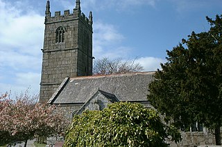
St Erth’s Church, St Erth, is a Grade I listed parish church in the Church of England Diocese of Truro in St Erth, Cornwall, England, UK.
Treveneague is an area near Goldsithney, Penzance, in the civil parish of St Hilary. It was originally composed of two places, North Treveneague and South Treveneague. The Grade II listed early 19th century North Treveneague Farmhouse and Farm Buildings North of Treveneague Farmhouse are located here. In the 1860s, an Iron Age fogou was discovered at Treveneague, the location of the fogou was located using Geophysics during a 1996 Time Team episode.
Gwinear-Gwithian and St Erth was an electoral division of Cornwall in the United Kingdom which returned one member to sit on Cornwall Council between 2009 and 2021. It was abolished at the 2021 local elections, being succeeded by Gwinear-Gwithian and Hayle East and Long Rock, Marazion and St Erth.

Marazion and Perranuthnoe was an electoral division of Cornwall in the United Kingdom which returned one member to sit on Cornwall Council between 2013 and 2021. It was abolished at the 2021 local elections, being succeeded by Long Rock, Marazion and St Erth.

Ludgvan was an electoral division of Cornwall in the United Kingdom which returned one member to sit on Cornwall Council between 2009 and 2021. It was abolished at the 2021 local elections, being split between Ludgvan, Madron, Gulval and Heamoor, Long Rock, Marazion and St Erth, St Ives East, Lelant and Carbis Bay, and St Ives West and Towednack.
| Unitary authorities | |
|---|---|
| Major settlements (cities in italics) |
|
| Rivers | |
| Topics | |
50°09′49″N5°24′01″W / 50.1637245°N 5.4002208°W
| | This article about a location in the former district of Penwith, Cornwall is a stub. You can help Wikipedia by expanding it. |