St Leonards, Hastings

Last updated

St Leonards
Photo of St Leonards Park, Hastings with Clubhouse.jpg
View of Saint Leonards Park
St Leonards, Hastings
Coordinates: 39°38′02″S176°50′02″E / 39.634°S 176.834°E / -39.634; 176.834
CountryNew Zealand
City Hastings
Local authority Hastings District Council
Electoral ward
  • Hastings-Havelock North General Ward
  • Takitimu Māori Ward
Area
[1]
  Land103 ha (255 acres)
Population
 (June 2023) [2]
  Total2,980
Camberley Frimley Mahora
Pfeil oben.svg
Pfeil links.svgSt LeonardsPfeil rechts.svg
Pfeil unten.svg
Tomoana
Raureka Hastings Central

St Leonards is an inner suburb of Hastings, New Zealand, in the Hawke's Bay region of New Zealand. It is named for St Leonards-on-Sea, a neighbouring town to Hastings' own English namesake.

The suburb is located immediately north and northwest of the city centre, with the city's main road, Heretaunga Street, passing through its centre.

St Leonard's Park is a sports field used for touch rugby in summer and football in winter. [3]

Demographics

St Leonards covers 1.03 km2 (0.40 sq mi) [1] and had an estimated population of 2,980 as of June 2023, [2] with a population density of 2,893 people per km2.

Historical population
YearPop.±% p.a.
20062,223    
20132,259+0.23%
20182,646+3.21%
Source: [4]

St Leonards had a population of 2,646 at the 2018 New Zealand census, an increase of 387 people (17.1%) since the 2013 census, and an increase of 423 people (19.0%) since the 2006 census. There were 954 households, comprising 1,311 males and 1,335 females, giving a sex ratio of 0.98 males per female. The median age was 35.9 years (compared with 37.4 years nationally), with 477 people (18.0%) aged under 15 years, 630 (23.8%) aged 15 to 29, 1,167 (44.1%) aged 30 to 64, and 366 (13.8%) aged 65 or older.

Ethnicities were 64.9% European/Pākehā, 25.6% Māori, 11.7% Pacific peoples, 11.6% Asian, and 1.7% other ethnicities. People may identify with more than one ethnicity.

The percentage of people born overseas was 23.8, compared with 27.1% nationally.

Although some people chose not to answer the census's question about religious affiliation, 43.4% had no religion, 39.9% were Christian, 2.9% had Māori religious beliefs, 2.0% were Hindu, 2.4% were Buddhist and 3.3% had other religions.

Of those at least 15 years old, 303 (14.0%) people had a bachelor's or higher degree, and 465 (21.4%) people had no formal qualifications. The median income was $27,100, compared with $31,800 nationally. 171 people (7.9%) earned over $70,000 compared to 17.2% nationally. The employment status of those at least 15 was that 1,134 (52.3%) people were employed full-time, 351 (16.2%) were part-time, and 84 (3.9%) were unemployed. [4]

Related Research Articles

<span class="mw-page-title-main">Seatoun</span> Suburb of Wellington City, New Zealand

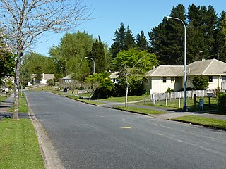
Seatoun, an eastern suburb of Wellington, the capital city of New Zealand, lies on the east coast of the Miramar Peninsula, close to the entrance to Wellington Harbour, some seven kilometres southeast of the CBD. The suburb sits on an exposed promontory close to Barrett Reef, a dangerous area of rocky shallows upon which many ships have foundered, most notably the inter-island ferry TEV Wahine in 1968.

Raureka is a suburb of Hastings City, in the Hawke's Bay Region of New Zealand's North Island.

<span class="mw-page-title-main">Ravensbourne, New Zealand</span> Suburb of Dunedin, New Zealand

Ravensbourne is a suburb of the New Zealand city of Dunedin. It is located on Otago Harbour on the steep southeastern slopes of Signal Hill. It lies on the harbour's northern shore, 4.5 kilometres (2.8 mi) east-northeast of the city centre.

Totara Heights is a suburb of Auckland, New Zealand. It is located south of Goodwood Heights, east of Wiri and north of The Gardens.

<span class="mw-page-title-main">Fitzroy, Hamilton</span> Suburb of Hamilton, New Zealand

Fitzroy is a suburb in southern Hamilton in New Zealand. It is named after Robert FitzRoy, who commanded HMS Beagle and was later the Governor of New Zealand. It was declared a suburb in 1974.

<span class="mw-page-title-main">Hamilton West, New Zealand</span> Suburb of Hamilton, New Zealand

Hamilton West is a suburb in western Hamilton in New Zealand.

One Tree Hill is a suburb of Auckland, New Zealand. The residential part of the suburb is located to the east and south-east of Maungakiekie / One Tree Hill, from which it takes its name, with the volcanic peak located within the suburb's boundaries.

<span class="mw-page-title-main">Sockburn, New Zealand</span> Suburb in Christchurch, New Zealand

Sockburn is an industrial suburb of Christchurch, New Zealand, located between Hornby and Riccarton, some 7 kilometres (4.3 mi) west of the Christchurch city centre. The suburb is roughly bounded by the triangle formed by State Highway 1 in the west, Main South Road (SH73a) in the south and SH73 in the north. The suburb of Wigram, containing the city's former RNZAF base, is located nearby. One of the city's main horseracing circuits, Riccarton Racecourse, is located close to Sockburn's northern edge, and Racecourse was the initial name for the area. The name Sockburn is likely to have come from the village of Sockburn in County Durham, England.

Windsor is a suburb of New Zealand's southernmost city, Invercargill.

Waipatu is a semi-rural suburb of Hastings, in the Hastings District and Hawke's Bay Region of New Zealand's North Island.

Camberley is a suburb of Hastings City, in the Hawke's Bay Region of New Zealand's North Island.

Frimley is a suburb of Hastings City, in the Hawke's Bay Region of New Zealand's North Island.

Mayfair is a suburb of Hastings City, in the Hawke's Bay Region of New Zealand's North Island.

Merivale or Parkvale is a suburb of Tauranga, in the Bay of Plenty Region of New Zealand's North Island.

<span class="mw-page-title-main">Pipitea, New Zealand</span> Suburb of Wellington City, New Zealand

Pipitea is a central suburb of Wellington, in the Wellington region of New Zealand's North Island.

<span class="mw-page-title-main">Wharemoa</span> Suburb of Greymouth, New Zealand

Wharemoa is a southeastern suburb of Greymouth on the West Coast of New Zealand. Marsden Road is a major road running through the suburb. Sawyers Creek runs northwest through the suburb to join the Grey River / Māwheranui near its mouth on the Tasman Sea.

<span class="mw-page-title-main">Russley</span> Suburb of Christchurch, New Zealand

Russley is a suburb on the western side of Christchurch city.

Broomfield is a suburb on the western side of Christchurch city.

Northcote is a suburb on the northern side of Christchurch, New Zealand.

<span class="mw-page-title-main">Avenal, New Zealand</span> Suburb in Invercargill, New Zealand

Avenal is a suburb of New Zealand's southernmost city, Invercargill. The suburb includes Queens Park and Southland Museum and Art Gallery.

References

  1. 1 2 "ArcGIS Web Application". statsnz.maps.arcgis.com. Retrieved 6 February 2023.
  2. 1 2 "Population estimate tables - NZ.Stat". Statistics New Zealand . Retrieved 25 October 2023.
  3. "St Leonard's Park". Hastings District Council. Retrieved 15 January 2021.
  4. 1 2 "Statistical area 1 dataset for 2018 Census". Statistics New Zealand. March 2020. St Leonards (209700). 2018 Census place summary: St Leonards