
Oadby and Wigston is a local government district and borough in the English county of Leicestershire. It was formed in 1974, under the Local Government Act 1972, from the merger of the Oadby and Wigston urban districts. The population of the district at the 2011 census was 56,170. The district forms part of the Harborough constituency.

Knighton is a residential suburban area of Leicester, situated between Clarendon Park to the north, Stoneygate to the east, Oadby and Wigston to the south and the Saffron Lane estate to the west.

Fulwood ward—which includes the districts of Fulwood, Lodge Moor, and Ranmoor—is one of the 28 electoral wards in City of Sheffield, England. It is located in the far western part of the city and covers an area of 23.2 km2. The population of this ward in 2011 was 18,233 people in 6,476 households. Fulwood ward is one of the five wards that make up the Sheffield Hallam Parliamentary constituency. In the 2004 local elections John Knight, Janice Sidebottom, and Andrew Sangar, all Liberal Democrats, were returned as councillors for the newly drawn ward. The current Member of Parliament is Labour's Olivia Blake.
Southmead is a northern suburb and council ward of Bristol, in the south west of England. The town of Filton, and the Bristol suburbs of Monks Park, Horfield, Henleaze and Westbury on Trym lie on its boundaries.

Leicester East is a constituency represented in the House of Commons of the UK Parliament since December 2019 by Claudia Webbe, who was elected as a Labour MP, but currently sits as an Independent due to her suspension from the party in September 2020 after she was charged with harassment.

Beaumont Leys is a suburb and electoral ward in north-western Leicester, England. The population of the ward at the 2011 census was 16,480. Locally, Beaumont Leys is usually used in reference to the large housing estate, built within the administrative division, centred on Strasbourg Drive.

Highfields is an inner city area of Leicester, England. It is one of the highest areas in the city, on high ground southeast of the city centre. To the west the area is bounded by the Midland Main Line, to the south by London Road (A6), and to the east by East Park Road. To the north is Spinney Hills, though there is no clear boundary between the two areas, and Spinney Hills is often considered to be part of Highfields. The neighbourhood is within walking distance of the city centre of Leicester and offers many amenities for religious, social, cultural and commercial activities. The population is split between the Spinney Hills, Wycliffe and Stoneygate wards of the Leicester City Council.

Leicester City Centre is Leicester's historical commercial, cultural and transport hub and is home to its central business district. Its inner core is roughly delineated by the A594, Leicester's inner ring road, although the various central campuses of the University of Leicester, De Monfort University and Leicester College are adjacent to the inner ring road and could be considered to be a continuation of the City centre. In a similar way, the Leicester Royal Infirmary precinct, the New Walk business district (Southfields), the Welford Road Stadium of Leicester Tigers' RUFC and the King Power Stadium of Premier League Leicester City to the south, and the Golden Mile to the north could also be deemed to be extensions to the central core.

The A594 Central Ring is the name of Leicester's central distributor road network.

The A563 is the designation for the ring road of Leicester, England. It forms a near-complete circuit except for a gap of around 2.2 miles (3.5 km) in the east of the city. An indirect route linking the gap involves the (A47) A6030, and A6. The A563 was formerly referred to as the Outer Ring.

Thorntree is a housing estate in east Middlesbrough within the unitary authority of Middlesbrough and the ceremonial county of North Yorkshire, England. The population of this Middlesbrough ward taken at the 2011 census was 6,290. It is so called because it was built on land which was Thorntree Farm. It has a public park called Thorntree Park. The main roads of the estate are College Road and The Greenway.
The Indices of deprivation 2004 is a deprivation index at the small area level, created by the British Department for Communities and Local Government(DCLG).

Palfrey is a neighbourhood in the Metropolitan Borough of Walsall, in the West Midlands.

Ferguslie Park is a residential suburb at the north-west extremity of Paisley in Renfrewshire, Scotland. It is bordered by the town of Linwood to the west and Glasgow Airport to the north. Ferguslie Park has history of being among the most deprived communities in Scotland. Attempts have been made at regeneration despite significant challenges.

Thorney Close is a suburb of Sunderland, Tyne and Wear in England.
The A607 is an A road in England that starts in Belgrave, Leicester and heads northeastwards through Leicestershire and the town of Grantham, Lincolnshire, terminating at Bracebridge Heath, a village on the outskirts of Lincoln. It is a primary route from Thurmaston to the A1 junction at Grantham.
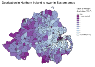
Indices of multiple deprivation (IMD) are widely-used datasets within the UK to classify the relative deprivation of small areas. Multiple components of deprivation are weighted with different strengths and compiled into a single score of deprivation.

Prebendal Farm is a housing estate in Aylesbury, Buckinghamshire, England. It is located to the south of the town, bordered by the Oxford Road, the railway and the Bearbrook.
Westcotes is an area to the west of the city of Leicester. It is also a ward of the City of Leicester whose population at the 2011 census was 11,644. It is also known as the West End of Leicester. The area is quite small in comparison with other areas of the city, but it is well known as it has many shops, bars and restaurants and is a popular choice for students and young professionals.

Charnwood was an electoral ward and administrative division of the city of Leicester, England. The population of the ward at the 2011 census was 13,291. It comprised the northern Leicester suburb of Northfields and its Tailby and Morton ex-council estates. Northfields has had a bad reputation for criminal activities. Despite being only 3 small estates it was responsible for 30% of the crime rate within the Leicester area. In response The Northfields Project was set upin order to help to combat crime and make Northfields a safer place to live. The scheme improved areas such as security fencing, lighting and public recreational spaces.