
Pembrokeshire is a county in the south-west of Wales. It is bordered by Carmarthenshire to the east, Ceredigion to the northeast, and otherwise by the sea. Haverfordwest is the largest town and administrative headquarters of Pembrokeshire County Council.

Haverfordwest is the county town of Pembrokeshire, Wales, and the most populous urban area in Pembrokeshire with a population of 14,596 in 2011. It is also a community, being the second most populous community in the county, with 12,042 people, after Milford Haven. The suburbs include the former parish of Prendergast, Albert Town and the residential and industrial areas of Withybush.
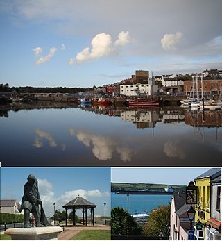
Milford Haven is both a town and a community in Pembrokeshire, Wales. It is situated on the north side of the Milford Haven Waterway, an estuary forming a natural harbour that has been used as a port since the Middle Ages.

Johnston (Pembs) railway station is an unstaffed railway station in the village of Johnston in Pembrokeshire, Wales. It opened in 1856 as part of the final section of the South Wales Railway main line from Haverfordwest to Neyland. It has gone by various names and is now operated by Transport for Wales Rail. Train stops are made at the station by request only.

Johnston is a village, parish and community in the former hundred of Roose, Pembrokeshire, Wales, and a parish in the diocese of Diocese of St David's.

Marloes is a village and parish in Pembrokeshire, Wales, on the Marloes Peninsula 7 miles (11 km) west of Milford Haven and forms the western tip of the southern shore of St Brides Bay. It is within part of the Pembrokeshire Coast National Park. The parish has 6 miles (9.7 km) of mainland coastline accessible throughout by the Pembrokeshire Coast Path and, together with St Brides, constitutes the community of Marloes and St Brides. In 2001, the population was 323.

Milford Haven Waterway is a natural harbour in Pembrokeshire, Wales. It is a ria or drowned valley which was flooded at the end of the last ice age. The Daugleddau estuary winds west to the sea. As one of the deepest natural harbours in the world, it is a busy shipping channel, trafficked by ferries from Pembroke Dock to Ireland, oil tankers and pleasure craft. Admiral Horatio Nelson, visiting the haven with the Hamiltons, described it as the next best natural harbour to Trincomalee in Ceylon and "the finest port in Christendom". Much of the coastline of the Waterway is designated as a Site of Special Scientific Interest, listed as Milford Haven Waterway SSSI.

Carew is a village, parish and community on an inlet of Milford Haven in the former Hundred of Narberth, Pembrokeshire, West Wales, 4 miles (6.4 km) east of Pembroke. The eastern part of the parish is in the Pembrokeshire Coast National Park.
Hasguard is a parish northwest of the town of Milford Haven in Pembrokeshire, Wales. The name applies to several other locations: Upper and Middle Hasguard, Hasguard Hall, Little Hasguard and Hasguard Cross, this last on the B4327 Haverfordwest to Dale road, and is a recorded historic place name by the Royal Commission.

Nolton and Roch is a community in the Hundred of Roose, Pembrokeshire, Wales. The community consists essentially of the villages of Nolton and Roch and a number of hamlets including Cuffern and Druidston. The western part of the community is in the Pembrokeshire Coast National Park. Its population (2001) was 746, increasing to 825 at the 2011 census.
St Ishmaels or St Ishmael's is a village, parish and community close to the Milford Haven Waterway in Pembrokeshire, Wales.

Jeffreyston is a village, parish and community in Pembrokeshire.
The town of Milford Haven was founded in 1793 by Sir William Hamilton, who initially invited Quaker whalers from Nantucket to live in his town, and then, in 1797, the Navy Board to create a dockyard for building warships.

Pill Priory is a Tironian house founded near Milford Haven, Pembrokeshire, South West Wales in the late 12th century.

The B4329 is a scenic route and a former turnpike in Pembrokeshire, West Wales. It links Eglwyswrw in the north of the county to Haverfordwest, the county town in the south, in an approximately southwesterly direction, crossing the Preseli Mountains. It links to the A487 trunk road at both its northern and southern ends.

Henry's Moat is a hamlet and parish in Pembrokeshire, Wales, in the community of Puncheston. It is 7 miles (11 km) southeast of Fishguard and 9 miles (14 km) northeast of Haverfordwest. The nearest railway station is Clarbeston Road 5 miles (8 km) to the south. It was in the ancient Hundred of Cemais.
The Pembrokeshire League is a football league in Pembrokeshire, West Wales, running from levels five to nine of the Welsh football league system.
Bentlass is a small rural riverside settlement in the community of Hundleton and parish of Monkton in south Pembrokeshire, Wales. There was for many years a ferry crossing between Bentlass and Pennar, a suburb of Pembroke Dock, and the place became national news in 1889 when a ferry accident occurred in which nine people died.


