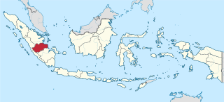
Jambi is a province of Indonesia. It is located on the east coast of central Sumatra and stretches to the Barisan Mountains in the west. Its capital and largest city is also called Jambi. It is bordered by the provinces of Riau to the north, West Sumatra to the west, Bengkulu to the southwest, South Sumatra to the south, and shares a maritime border with the Riau Islands to the east and the Pacific Ocean to the east. The province has a land area of 49,026.58 km2, and a sea area of 3,274.95 km2. Its area is comparable to the European country of Slovakia. It had a population of 3,092,265 according to the 2010 census and 3,548,228 according to the 2020 census; the official estimate of population as of mid-2023 was 3,679,169.

Dumai, is a coastal city in Riau Province on the island of Sumatra, Indonesia, about 188 km from Pekanbaru, the provincial capital. The city has an area of 2,065.59 km2 and had 338,064 inhabitants at the mid 2023 official estimate. Dumai has a domestic airport, Pinang Kampai Airport. The city is an important transport and trade centre, both regionally and internationally, especially for traffic to and from Malaysia. The region is rich in oil.

Bogor Regency is a landlocked regency (kabupaten) of West Java province in Indonesia, situated south of DKI Jakarta. Covering an area of 2,734.33 km2, it is considered a bedroom community for Jakarta, and was home to 5,427,068 people at the 2020 census. The official estimate as at mid 2023 was 5,520,836. The town of Cibinong serves as the regency seat.

Sukabumi Regency is a regency (kabupaten) in southwestern Java, as part of West Java province of Indonesia. The regency seat is located in Palabuhan Ratu, a coastal district facing the Indian Ocean. The regency fully encircles the administratively separated city of Sukabumi. Covering an area of 4,164.15 km2, the regency is the largest regency in West Java and the second largest regency on Java after the Banyuwangi Regency in East Java. The regency had a population of 2,341,409 at the 2010 census and 2,725,450 at the 2020 census; the official estimate as at mid 2023 was 2,802,404, with a large proportion of it living in the northeastern part of the regency that encircles Sukabumi City, south of Mount Gede. A plan to create a new regency, the putative North Sukabumi Regency, was considered by the Indonesian government in 2013, but has been deferred until the end of the current morotorium on new creations of regencies.

Karawang Regency is a regency (kabupaten) of West Java, Indonesia. The town of Karawang is its administrative centre. The regency covers an area of 1,911.09 km2 and had a population of 2,127,791 people at the 2010 Census, which grew to 2,361,019 at the 2020 Census. The official estimate for mid-2023 was 2,526,002 - comprising 1,277,610 males and 1,248,392 females. The regency borders Bekasi and Bogor Regencies in the west, the Java Sea in the north, Subang Regency in the east, Purwakarta Regency in the southeast, and Cianjur Regency in the south. The regency lies on the eastern outskirts of Metropolitan Jakarta, just outside the Jabodetabek region, and is the site of considerable industrial activity.

Bengkulu, formerly Bencoolen is the capital of the Indonesian province of Bengkulu. The city is the second largest city on the west coast of Sumatra Island after Padang. Previously this area was under the influence of the kingdom of Inderapura and the Sultanate of Banten. The city also became the place of exile of Sukarno from 1939 to 1942. It covers an area of 151.70 km2 and had a population of 308,544 at the 2010 Census and 373,591 at the 2020 Census; the official estimate as of mid-2023 was 391,117. The city is the only city in Bengkulu Province.

Tabalong Regency is the most northerly of the regencies in the Indonesian province of South Kalimantan, on Borneo Island. It was created on 14 July 1965 by splitting off the former northern districts of North Hulu Sungai Regency. It has a land area of 3,553.36 km2, and had a population at the 2010 Census of 218,620 and 253,305 at the 2020 Census; the official estimate as of mid-2023 was 262,631. The administrative capital is the town of Tanjung. The Regency's motto is "Saraba Kawa".

Bintan Regency is an administrative area in the Riau Islands Province of Indonesia. Bintan Regency includes all of Bintan Island and also includes many outlying islands including the Tambelan Archipelago and Badas Islands situated between Bintan and West Kalimantan; altogether there are 273 islands comprising the regency.

The Karimun Regency is located in the Riau Islands Province, Indonesia. Besides the central island of Great Karimun, the regency also includes the island of Kundur and over 240 lesser islands. The district covers a land area of 1,339.9 km2 and a sea area of 6,460 km2, and its population was 212,561 at the 2010 census and 253,457 at the 2020 census; the official estimate as at mid 2023 was 270,121.

Humbang Hasundutan Regency is a landlocked regency in North Sumatra province of Indonesia. In the east of the regency, Baktiraja District stretches along a short part of the southern shore of Lake Toba in North Sumatra. The regency covers an area of 2,502.71 square kilometres (966.30 sq mi), and it had a population of 171,650 at the 2010 census and 197,751 at the 2020 census; the official estimate as at mid 2023 was 204,700. Its seat is the town of Dolok Sanggul. To the north is Samosir Regency and Pakpak Bharat Regency, to the east is North Tapanuli Regency, and to the west and south is Central Tapanuli Regency, and beyond the latter the Indian Ocean.

North Padang Lawas is a landlocked regency in the North Sumatra province of Indonesia. It has an area of 3,918.05 km2, and had a population of 223,049 at the 2010 census and 260,720 at the 2020 census; the official estimate as of mid-2023 was 275,448. North Padang Lawas Regency was created on 17 July 2007 from the eastern parts of the South Tapanuli Regency. Its administrative seat is the town of Gunung Tua.

Pakpak Bharat Regency is a landlocked regency in North Sumatra Province of Indonesia. It was created on 25 February 2003 from the southern districts of Dairi Regency. The regency covers an area of 1,365.6 square kilometres and it had a population of 40,481 at the 2010 census and 52,351 at the 2020 Census; the official estimate as at mid 2023 was 55,172 - comprising 27,890 males and 27,282 females. Its seat is the town of Salak. It is the least populated regency in North Sumatra; its population is roughly the same as Greenland, the island with the lowest population density in the world.

North Central Timor Regency is a regency in East Nusa Tenggara Province, Indonesia. It covers an area of 2,674.02 km2, and had a population of 229,803 at the 2010 Census and 259,829 at the 2020 Census; the official estimate as at mid 2023 was 269,628. Its regency seat is located at the town of Kefamenanu, which had a population of 47,628 in mid 2023. The regency borders Timor Leste's Oecusse enclave, one of few Indonesian regions that have a land border with other countries.

Malinau Regency is a regency of North Kalimantan Province in Indonesia. It was created on 4 October 1999 from the western districts of Bulungan Regency. The administrative centre is the town of Malinau. The regency is home to the Kayan Mentarang National Park. It covers an area of 38,911.80 km2, and had a population of 62,423 at the 2010 Census and 82,510 at the 2020 Census; the official estimate as at mid 2023 was 85,073. It is the regency with the largest area in the province, as well as the least densely populated. Other than that, Malinau is the only regency in North Kalimantan that is predominantly Protestant and the second most-developed region in North Kalimantan after Tarakan in terms of Human Development Index.

Tukak Sadai is a district of South Bangka Regency, Bangka-Belitung Islands. The district is located in the southeastern section of Bangka Island, and contains the Sadai seaport.
Air Gegas is a district of South Bangka Regency, Bangka-Belitung Islands. It is the second largest and second most populated district in the regency after the regency seat of Toboali.
Payung is a district of South Bangka Regency, Bangka-Belitung Islands. It is located in the northern part of the regency, bordering the Central Bangka Regency.
Simpang Rimba is a district of South Bangka Regency, Bangka-Belitung Islands. It is the fourth largest and third most populated district in the regency, with a population of over 25,000.

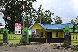
Tebing Tinggi is a town and administrative district (kecamatan) in Empat Lawang Regency, of South Sumatra province of Indonesia and it is the seat (capital) of Empat Lawang Regency. The total area of Tebing Tinggi District is 362.93 km2 (140.13 sq mi). and it had a population of 71,060 according to the official estimate as at mid 2023.