Surazh

Last updated
Surazh
Сураж(Russian)
-   Town [1]   -
Map of Russia - Bryansk Oblast (2008-03).svg
Location of Bryansk Oblast in Russia
Map Russia Bryansk region.svg
Red pog.svg
Surazh
Location of Surazh in Bryansk Oblast
Coordinates: 53°01′N32°23′E / 53.017°N 32.383°E / 53.017; 32.383 Coordinates: 53°01′N32°23′E / 53.017°N 32.383°E / 53.017; 32.383
Coat of Arms of Surazh (Bryansk oblast) (1782).png
Coat of arms
Administrative status  (as of November 2012)
Country Russia
Federal subject Bryansk Oblast [1]
Administrative district Surazhsky District [2]
Urban Administrative Okrug Surazhsky [2]
Administrative center of Surazhsky District, [1] Surazhsky Urban Administrative Okrug [2]
Municipal status  (as of August 2012)
Municipal district Surazhsky Municipal District [3]
Urban settlement Surazhskoye Urban Settlement [3]
Administrative center of Surazhsky Municipal District, [3] Surazhskoye Urban Settlement [3]
Statistics
Population (2010 Census) 11,640 inhabitants [4]
Time zone MSK (UTC+03:00) [5]
First mentioned17th century[ citation needed ]
Previous names Surazhichi (until 1781),[ citation needed ]
Surazh-na-Iputi (until 1797)[ citation needed ]
Website
Surazh on Wikimedia Commons

Surazh (Russian : Сураж) is a town and the administrative center of Surazhsky District in Bryansk Oblast, Russia, located on the Iput River 177 kilometers (110 mi) southwest of Bryansk, the administrative center of the oblast. Population: 11,640(2010 Census); [4] 12,046(2002 Census); [6] 12,559(1989 Census); [7] 1,599 (1897).

Russian language East Slavic language

Russian is an East Slavic language, which is official in the Russian Federation, Belarus, Kazakhstan and Kyrgyzstan, as well as being widely used throughout Eastern Europe, the Baltic states, the Caucasus and Central Asia. It was the de facto language of the Soviet Union until its dissolution on 25 December 1991. Although, nowadays, nearly three decades after the breakup of the Soviet Union, Russian is used in official capacity or in public life in all the post-Soviet nation-states, as well as in Israel and Mongolia, the rise of state-specific varieties of this language tends to be strongly denied in Russia, in line with the Russian World ideology.

The classification system of the types of inhabited localities in Russia, the former Soviet Union, and some other post-Soviet states has certain peculiarities compared with the classification systems in other countries.

Surazhsky District District in Bryansk Oblast, Russia

Surazhsky District is an administrative and municipal district (raion), one of the twenty-seven in Bryansk Oblast, Russia. It is located in the west of the oblast. The area of the district is 1,128 square kilometers (436 sq mi). Its administrative center is the town of Surazh. Population: 24,623 (2010 Census); 27,223 ; 31,697 (1989 Census). The population of Surazh accounts for 47.3% of the district's total population.

Contents

History

It was first mentioned in the 17th century as the village of Surazhichi (Суражичи); later as a sloboda .[ citation needed ] Since 1781 it has been known as the town of Surazh-na-Iputi (Сураж-на-Ипути), and since 1797—as simply Surazh.[ citation needed ]

Sloboda

A sloboda was a kind of settlement in the history of Russia, Belarus, and Ukraine. The name is derived from the early Slavic word for "freedom" and may be loosely translated as "(tax-)free settlement". In modern Russia, the term is used to denote a type of a rural locality and is used in Kursk, Lipetsk, Nizhny Novgorod, Oryol, Rostov, Ryazan, Tula, and Voronezh Oblasts.

In the town of Surazh, there were 461 Jews in 1939 (15.4 % of the total population). In 1917, there were 6 synagogues. All of them were wooden, except one made out of stone. The village was under German occupation from 1941 to 1943. Nazis carried out the murder of the Jews of Surazh in conjunction with an antipartisan operation. On August 12, 1941, between 600 and 750 Jews were gathered by the Germans on the location of the former printing office in Sourazh. Then, they were taken and shot behind the linen factory, 2 km away from the village, in pits of the ravine, known as Loubtchyno. The bodies of the victims were exhumed and reburied after the war in the Jewish cemetery. [8]

Administrative and municipal status

Within the framework of administrative divisions, Surazh serves as the administrative center of Surazhsky District. [1] As an administrative division, it is incorporated within Surazhsky District as Surazhsky Urban Administrative Okrug . [2] As a municipal division, Surazhsky Urban Administrative Okrug is incorporated within Surazhsky Municipal District as Surazhskoye Urban Settlement. [3]

Town of district significance is an administrative division of a district in a federal subject of Russia. It is equal in status to a selsoviet or an urban-type settlement of district significance, but is organized around a town ; often with surrounding rural territories.

Related Research Articles

An oblast is a type of administrative division of Belarus, Bulgaria, Kazakhstan, Kyrgyzstan, Russia, Ukraine, and the former Soviet Union and Kingdom of Yugoslavia.

Suraż Place in Podlaskie, Poland

Suraż is a town in north-eastern Poland situated in the Podlaskie Voivodeship since 1999 and, from 1975 to 1998, in the Białystok Voivodeship.

Vitebsk Region Place in Vitsebsk

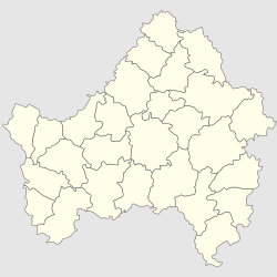
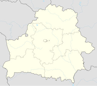
Vitebsk Region, Vitsebsk Voblast, or Vitebsk Oblast is a region (voblast) of Belarus with its administrative center being Vitebsk (Vitsebsk). It is located near the border with Russia.

Urban-type settlement is an official designation for a semi-urban settlement, used in several Eastern European countries. The term was historically used in Bulgaria, Poland, and the Soviet Union, and remains in use today in 10 of the post-Soviet states.

Białystok County County in Podlaskie, Poland

Białystok County is a unit of territorial administration and local government (powiat) in Podlaskie Voivodeship, north-eastern Poland, on the border with Belarus. It was created on 1 January 1999 as a result of the Polish local government reforms passed in 1998. Its administrative seat is the city of Białystok, although the city is not part of the county. The county contains nine towns: Łapy, 25 km (16 mi) south-west of Białystok, Czarna Białostocka, 22 km (14 mi) north of Białystok, Wasilków, 11 km (7 mi) north of Białystok, Choroszcz, 13 km (8 mi) west of Białystok, Supraśl, 16 km (10 mi) north-east of Białystok, Michałowo, 13 km (8 mi) east of Białystok, Zabłudów, 16 km (10 mi) south-east of Białystok, Tykocin, 29 km (18 mi) west of Białystok, and Suraż, 23 km (14 mi) south-west of Białystok.

Lovat River river in Belarus and Russia, tributary of Lake Ilmen

The Lovat is a river in Vitebsk Oblast of Belarus, Usvyatsky, Velikoluksky, and Loknyansky Districts, as well as of the city of Velikiye Luki, of Pskov Oblast and Kholmsky, Poddorsky, Starorussky, and Parfinsky Districts of Novgorod Oblast in Russia. The source of the Lovat is Lake Lovatets in northeastern Belarus, and the Lovat is a tributary of Lake Ilmen. Its main tributaries are the Loknya (left), the Kunya (right), the Polist (left), the Redya (left), and the Robya (right) Rivers. The towns of Velikiye Luki and Kholm, as well as the urban-type settlement of Parfino, are located on the banks of the Lovat.

Klintsy Town in Bryansk Oblast, Russia

Klintsy is a town in Bryansk Oblast, Russia, located on the Turosna River, 164 kilometers southwest of Bryansk. Population: 62,510 (2010 Census); 67,325 (2002 Census); 71,161 (1989 Census); 60,000 (1972).

Kasplya is a river in Smolensky, Demidovsky, and Rudnyansky Districts of Smolensk Oblast of Russia and in Vitebsk Region of Belarus, and a major left tributary of the Daugava River. Its length is 136 kilometres (85 mi), the first 116 kilometres (72 mi) are in Russia, and the rest in Belarus. It joins the Daugava in the urban-type settlement of Surazh. The town of Demidov is situated on the Kasplya.

Surazh, Russia Town in Bryansk Oblast, Russia

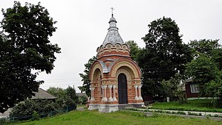
Surazh is a town and the administrative center of Surazhsky District in Bryansk Oblast, Russia, located on the Iput River 177 kilometers (110 mi) southwest of Bryansk, the administrative center of the oblast. Population: 11,640 (2010 Census); 12,046 (2002 Census); 12,559 (1989 Census); 1,599 (1897).

Iput River river in Belarus

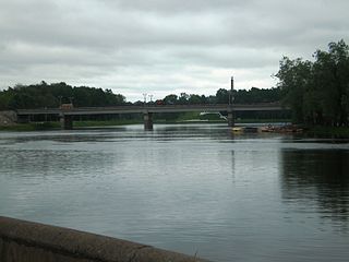
The Iput, or Ipuć is a river in Mogilev and Gomel Regions in Belarus and Smolensk and Bryansk Oblasts in Russia. It is a left tributary of the Sozh River. The length of the Iput River is 437 kilometres (272 mi). The area of its basin is 10,900 square kilometres (4,200 sq mi). It freezes up in late November and stays icebound until late March to early April. Its main tributaries are the Voronitsa and Unecha Rivers. The towns of Surazh and Dobrush are located on the Iput River.

In Soviet and Belarusian historiography, the Vitebsk or Surazh gate was the name given to the corridor connecting Soviet and German-occupied territories during World War II. The 40km area between Velizh and Usvyaty was a point of contact between the German Army Groups North and Centre. The gate, created by the Soviet 4th Shock Army Toropets–Kholm Offensive during the winter of 1941–42, existed from 10 February to 28 September 1942.

Belostok Oblast

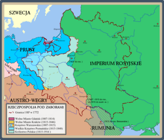
Belostok Oblast was an administrative division in the Russian Empire. The region had a capital in Belostok.

Minay Shmyryov politician

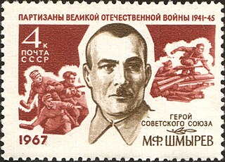
Minay Filippovich Shmyryov, also transliterated as Minay Shmyrev and Minai Shmyrev, was one of the leaders of the Belarusian partisan resistance against the German occupation during World War II.

Kastsyukovichy Place

Kastsyukovichy is a town in Mogilev Region, Eastern Belarus. It is located in the east of the Region, close to the border with Russia, and serves as the administrative center of Kastsyukovichy District. As of 2009, its population was 15,993.

Vitebsk Governorate governorate of the Russian Empire

Vitebsk Governorate was an administrative unit (guberniya) of the Russian Empire, with the seat of governorship in Vitebsk. It was established in 1802 by splitting the Byelorussia Governorate and existed until 1924. Today most of the area belongs to Belarus, the northwestern part to Latvia and the northeastern part to Pskov and Smolensk Oblasts of Russia.

Usvyacha River river in Belarus

The Usvyacha is a river in Kunyinsky and Usvyatsky Districts of Pskov Oblast in Russia and in Vitebsk Raion of Vitebsk Region in Belarus. It is a right tributary of the Daugava River. It is 100 kilometres (62 mi) long, and the area of its basin 2,340 square kilometres (900 sq mi).

Royal city in Poland

In the history of Poland, a royal city or royal town was an urban settlement within the crown lands.

Surazh is an urban-type settlement in Vitebsk Region of Belarus, approximately 45km northeast from the city of Vitebsk. It is situated at the crossing of the Daugava and Kasplya rivers.

References

A small church in the town built in 1907 Surazh Iskritsk.jpg
A small church in the town built in 1907

Notes

  1. 1 2 3 4 Law #13-Z
  2. 1 2 3 4 Law #69-Z
  3. 1 2 3 4 5 Law #3-Z
  4. 1 2 Russian Federal State Statistics Service (2011). "Всероссийская перепись населения 2010 года. Том 1" [2010 All-Russian Population Census, vol. 1]. Всероссийская перепись населения 2010 года (2010 All-Russia Population Census) (in Russian). Federal State Statistics Service . Retrieved June 29, 2012.
  5. Правительство Российской Федерации. Федеральный закон №107-ФЗ от 3 июня 2011 г. «Об исчислении времени», в ред. Федерального закона №271-ФЗ от 03 июля 2016 г. «О внесении изменений в Федеральный закон "Об исчислении времени"». Вступил в силу по истечении шестидесяти дней после дня официального опубликования (6 августа 2011 г.). Опубликован: "Российская газета", №120, 6 июня 2011 г. (Government of the Russian Federation. Federal Law #107-FZ of June 31, 2011 On Calculating Time , as amended by the Federal Law #271-FZ of July 03, 2016 On Amending Federal Law "On Calculating Time". Effective as of after sixty days following the day of the official publication.).
  6. Russian Federal State Statistics Service (May 21, 2004). "Численность населения России, субъектов Российской Федерации в составе федеральных округов, районов, городских поселений, сельских населённых пунктов – районных центров и сельских населённых пунктов с населением 3 тысячи и более человек" [Population of Russia, Its Federal Districts, Federal Subjects, Districts, Urban Localities, Rural Localities—Administrative Centers, and Rural Localities with Population of Over 3,000](XLS). Всероссийская перепись населения 2002 года [All-Russia Population Census of 2002] (in Russian). Retrieved August 9, 2014.
  7. Demoscope Weekly (1989). "Всесоюзная перепись населения 1989 г. Численность наличного населения союзных и автономных республик, автономных областей и округов, краёв, областей, районов, городских поселений и сёл-райцентров" [All Union Population Census of 1989: Present Population of Union and Autonomous Republics, Autonomous Oblasts and Okrugs, Krais, Oblasts, Districts, Urban Settlements, and Villages Serving as District Administrative Centers]. Всесоюзная перепись населения 1989 года [All-Union Population Census of 1989] (in Russian). Институт демографии Национального исследовательского университета: Высшая школа экономики [Institute of Demography at the National Research University: Higher School of Economics]. Retrieved August 9, 2014.
  8. http://yahadmap.org/#village/surazh-vitebsk-belarus.470

Sources

World War II 1939–1945 global war

World War II, also known as the Second World War, was a global war that lasted from 1939 to 1945. The vast majority of the world's countries—including all the great powers—eventually formed two opposing military alliances: the Allies and the Axis. A state of total war emerged, directly involving more than 100 million people from over 30 countries. The major participants threw their entire economic, industrial, and scientific capabilities behind the war effort, blurring the distinction between civilian and military resources. World War II was the deadliest conflict in human history, marked by 50 to 85 million fatalities, most of whom were civilians in the Soviet Union and China. It included massacres, the genocide of the Holocaust, strategic bombing, premeditated death from starvation and disease, and the only use of nuclear weapons in war.

Yad Vashem Israels official memorial to the Jewish victims of the Holocaust

Yad Vashem is Israel's official memorial to the victims of the Holocaust. It is dedicated to preserving the memory of the dead; honoring Jews who fought against their Nazi oppressors and Gentiles who selflessly aided Jews in need; and researching the phenomenon of the Holocaust in particular and genocide in general, with the aim of avoiding such events in the future.