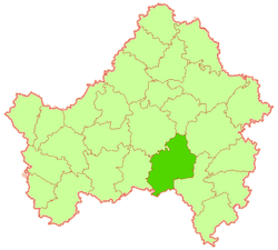
Brasovsky District is an administrative and municipal district (raion), one of the twenty-seven in Bryansk Oblast, Russia. It is located in the east of the oblast. The area of the district is 1,185 square kilometers (458 sq mi). Its administrative center is the urban locality of Lokot. Population: 21,471 (2010 Census); 24,972 ; 26,873 (1989 Census). The population of Lokot accounts for 46.7% of the district's total population.
Dubrovsky District is an administrative and municipal district (raion), one of the twenty-seven in Bryansk Oblast, Russia. It is located in the north of the oblast. The area of the district is 1,028 square kilometers (397 sq mi). Its administrative center is the urban locality of Dubrovka. Population: 20,094 (2010 Census); 23,145 ; 21,694 (1989 Census). The population of Dubrovka accounts for 39.9% of the district's total population.

Gordeyevsky District is an administrative and municipal district (raion), one of the twenty-seven in Bryansk Oblast, Russia. It is located in the west of the oblast. The area of the district is 846.54 square kilometers (326.85 sq mi). Its administrative center is the rural locality of Gordeyevka. As of the 2010 Census, the total population of the district was 12,218, with the population of Gordeyevka accounting for 25.4% of that number.

Kletnyansky District is an administrative and municipal district (raion), one of the twenty-seven in Bryansk Oblast, Russia. It is located in the northwest of the oblast. The area of the district is 1,583 square kilometers (611 sq mi). Its administrative center is the urban locality of Kletnya. Population: 20,166 (2010 Census); 22,501 ; 23,885 (1989 Census). The population of Kletnya accounts for 66.0% of the district's total population.
Klimovsky District is an administrative and municipal district (raion), one of the twenty-seven in Bryansk Oblast, Russia. It is located in the southwest of the oblast. The area of the district is 1,554 square kilometers (600 sq mi). Its administrative center is the urban locality of Klimovo. Population: 30,003 (2010 Census); 34,556 ; 40,119 (1989 Census). The population of Klimovo accounts for 46.3% of the district's total population.

Komarichsky District is an administrative and municipal district (raion), one of the twenty-seven in Bryansk Oblast, Russia. It is located in the southeast of the oblast. The area of the district is 1,020 square kilometers (390 sq mi). Its administrative center is the urban locality of Komarichi. Population: 18,064 (2010 Census); 20,065 ; 21,649 (1989 Census). The population of Komarichi accounts for 42.5% of the district's total population.
Krasnogorsky District is an administrative and municipal district (raion), one of the twenty-seven in Bryansk Oblast, Russia. It is located in the west of the oblast. The area of the district is 1,081 square kilometers (417 sq mi). Its administrative center is the urban locality of Krasnaya Gora. Population: 13,208 (2010 Census); 16,863 ; 23,26 (1989 Census). The population of Krasnaya Gora accounts for 44.7% of the district's total population.
Mglinsky District is an administrative and municipal district (raion), one of the twenty-seven in Bryansk Oblast, Russia. It is located in the west of the oblast. The area of the district is 1,088 square kilometers (420 sq mi). Its administrative center is the town of Mglin. Population: 19,458 (2010 Census); 22,551 ; 24,564 (1989 Census). The population of Mglin accounts for 40.7% of the district's total population.

Navlinsky District is an administrative and municipal district (raion), one of the twenty-seven in Bryansk Oblast, Russia. It is located in the east of the oblast. The area of the district is 2,012 square kilometers (777 sq mi). Its administrative center is the urban locality of Navlya. Population: 28,341 (2010 Census); 29,783 ; 32,189 (1989 Census). The population of Navlya accounts for 50.7% of the district's total population.

Novozybkovsky District is an administrative and municipal district (raion), one of the twenty-seven in Bryansk Oblast, Russia. It is located in the west of the oblast. The area of the district is 990 square kilometers (380 sq mi). Its administrative center is the town of Novozybkov. Population: 12,415 (2010 Census); 14,170 ; 18,424 (1989 Census).

Pochepsky District is an administrative and municipal district (raion), one of the twenty-seven in Bryansk Oblast, Russia. It is located in the center of the oblast. The area of the district is 1,886 square kilometers (728 sq mi). Its administrative center is the town of Pochep. As of the 2010 Census, the total population of the district was 42,365, with the population of Pochep accounting for 40.5% of that number.

Pogarsky District is an administrative and municipal district (raion), one of the twenty-seven in Bryansk Oblast, Russia. It is located in the south of the oblast. The area of the district is 1,196 square kilometers (462 sq mi). Its administrative center is the urban locality of Pogar. Population: 28,333 (2010 Census); 35,588 ; 37,523 (1989 Census). The population of Pogar accounts for 35.3% of the district's total population.
Rognedinsky District is an administrative and municipal district (raion), one of the twenty-seven in Bryansk Oblast, Russia. It is located in the north of the oblast. The area of the district is 1,051 square kilometers (406 sq mi). Its administrative center is the urban locality of Rognedino. Population: 7,284 (2010 Census); 8,952 ; 11,014 (1989 Census). The population of Rognedino accounts for 43.4% of the district's total population.

Sevsky District is an administrative and municipal district (raion), one of the twenty-seven in Bryansk Oblast, Russia. It is located in the southeast of the oblast. The area of the district is 1,220 square kilometers (470 sq mi). Its administrative center is the town of Sevsk. Population: 16,923 (2010 Census); 18,759 ; 20,946 (1989 Census). The population of Sevsk accounts for 43.0% of the district's total population.
Starodubsky District is an administrative and municipal district (raion), one of the twenty-seven in Bryansk Oblast, Russia. It is located in the south of the oblast. The area of the district is 1,760 square kilometers (680 sq mi). Its administrative center is the town of Starodub. Population: 40,414 (2010 Census); 44,573 ; 51,326 (1989 Census). The population of Starodub accounts for 47.0% of the district's total population.

Suzemsky District is an administrative and municipal district (raion), one of the twenty-seven in Bryansk Oblast, Russia. It is located in the southeast of the oblast. The area of the district is 1,339.32 square kilometers (517.11 sq mi). Its administrative center is the urban locality of Suzemka. Population: 16,654 (2010 Census); 19,513 ; 20,786 (1989 Census). The population of Suzemka accounts for 54.8% of the district's total population.

Vygonichsky District is an administrative and municipal district (raion), one of the twenty-seven in Bryansk Oblast, Russia. It is located in the center of the oblast. The area of the district is 1,028 square kilometers (397 sq mi). Its administrative center is the urban locality of Vygonichi. Population: 20,105 (2010 Census); 22,770 ; 23,058 (1989 Census). The population of Vygonichi accounts for 24.6% of the district's total population.

Zhukovka is a town and the administrative center of Zhukovsky District in Bryansk Oblast, Russia, located on the left bank of the Desna River 56 kilometers (35 mi) northwest of Bryansk, the administrative center of the oblast. Population: 18,269 (2010 Census); 19,731 (2002 Census); 19,706 (1989 Census).
Bolshoye Polpino is an urban locality under the administrative jurisdiction of the town of oblast significance of Bryansk of Bryansk Oblast, Russia. Population: 6,356 (2010 Census); 4,613 (2002 Census); 6,374 (1989 Census).
Raditsa-Krylovka is an urban locality under the administrative jurisdiction of the town of oblast significance of Bryansk of Bryansk Oblast, Russia. Population: 3,526 (2010 Census); 3,513 (2002 Census); 3,818 (1989 Census).