Highway 17 is a provincial highway in British Columbia, Canada. It comprises two separate sections connected by a ferry link. The Vancouver Island section is known as the Patricia Bay Highway and connects Victoria to the Swartz Bay ferry terminal in North Saanich. The Lower Mainland section is known as the South Fraser Perimeter Road and connects the Tsawwassen ferry terminal to Delta and Surrey, terminating at an interchange with Highway 1 in the Fraser Valley.

Highway 17A is a 6 km (3.7 mi) long route connecting Highway 99 and Highway 17; this route was originally numbered Highway 17 between these two points but the numbering was altered once the South Fraser Perimeter Road neared completion.

Horseshoe Bay is a community of about 1,000 permanent residents in West Vancouver, in the Canadian province of British Columbia. Situated on the western tip of West Vancouver at the entrance to Howe Sound, the village marks the western end of Highway 1 on mainland British Columbia. It also serves as the southern end of the Sea-to-Sky Highway, with Lions Bay just 15 minutes north.

Mayne Island is a 21-square-kilometre (8.1 sq mi) island in the southern Gulf Islands chain of British Columbia. It is midway between the Lower Mainland of BC and Vancouver Island, and has a population of over 1300. Mount Parke in the south-central heart of the island is its highest peak at 255 metres.
Brentwood Bay is a small village in the municipality of Central Saanich, on the Saanich Peninsula in British Columbia, Canada. It lies north of the city of Victoria, east of the community of Willis Point, and south of the town of Sidney.
The District of North Saanich is located on the Saanich Peninsula of British Columbia, approximately 25 km (16 mi) north of Victoria on southern Vancouver Island. It is one of the 13 Greater Victoria municipalities. The district is surrounded on three sides by 20 km (12 mi) of ocean shoreline, and consists of rural/residential areas and a large agricultural base. It is home to the Victoria International Airport and the Swartz Bay Ferry Terminal.

PKOLS, formerly called Mount Douglas, is a prominent, 225 m (738 ft) hill in Saanich, British Columbia. It is located in PKOLS in the municipality of Saanich.

Ganges, British Columbia is an unincorporated community on Salt Spring Island in the province of British Columbia, Canada.

Saanich is the language of the First Nations Saanich people in the Pacific Northwest region of northwestern North America. Saanich is a Coast Salishan language in the Northern Straits dialect continuum, the varieties of which are closely related to the Klallam language.
Bamberton Provincial Park is a provincial park located in Mill Bay, British Columbia, Canada. The park area consists of a beach that borders on Saanich Inlet, and is connected to a camping area by several trails. The traditional name of the beach is qʷələs in the Saanich dialect. It shares its name with the now abandoned company town of Bamberton.

Montague Harbour Marine Provincial Park is a provincial park in British Columbia, Canada, located on Galiano Island, one of the Gulf Islands off BC's South Coast in Canada. It is accessible by BC Ferries from Swartz Bay on Vancouver Island or Tsawwassen on the Mainland. The Island's ferry terminal is at Sturdies Bay, about 6 km (3.7 mi) from Montague.
Saanich Peninsula is located north of Victoria, British Columbia, Canada. It is bounded by Saanich Inlet on the west, Satellite Channel on the north, the small Colburne Passage on the northeast, and Haro Strait on the east. The exact southern boundary of what is referred to as the "Saanich Peninsula" is somewhat fluid in local parlance.

Saanichton, British Columbia is a village, in the municipality of Central Saanich, located between Victoria and the Swartz Bay Ferry Terminal, west of the Pat Bay Highway, at the junction of Mount Newton Cross Road and East Saanich Road.
Sturdies Bay is on the south east part of Galiano Island in British Columbia, Canada's Gulf Islands. It is known primarily for its ferry terminal, that connects it to the Tsawwassen Ferry Terminal and the other southern Gulf Islands. At the ferry terminal there is also a public dock, serviced in the summer by an inter-island water taxi, and in the school year the same vessel picks up students here to bring them to schools on Pender and Saltspring Islands.

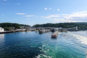
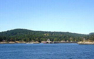
Swartz Bay is a 22.7 ha (56.1-acre) ferry terminal and a major transportation facility at Swartz Bay in North Saanich, British Columbia. It is located 32 km (20 mi) north of Victoria on Vancouver Island. The terminal is part of the BC Ferries system, as well as part of Highway 17.

Active Pass is a strait separating Galiano Island in the north and Mayne Island in the south in the southern Gulf Islands, British Columbia, Canada. It connects the Trincomali Channel in the west and the Strait of Georgia in the east. The pass stretches 5.5 km from northeast to southwest with two roughly right-angle bends, one at each end.

Gordon Head is a seaside neighbourhood in the municipality of Saanich in Greater Victoria, British Columbia, Canada. Gordon Head lies north of McKenzie Avenue and east of the Blenkinsop Valley. The University of Victoria is located partly within Gordon Head along the southeast boundary. Finnerty Road separates Gordon Head from the adjacent neighbourhood of Cadboro Bay. The local area is dominated physically by Mount Douglas, a coastline along Haro Strait, and the central plateau.

Victoria Harbour is a harbour, seaport, and seaplane airport in the Canadian city of Victoria, British Columbia. It serves as a cruise ship and ferry destination for tourists and visitors to the city and Vancouver Island. It is both a port of entry and an airport of entry for general aviation. Historically it was a shipbuilding and commercial fishing centre. While the Inner Harbour is fully within the City of Victoria, separating the city's downtown on its east side from the Victoria West neighbourhood, the Upper Harbour serves as the boundary between the City of Victoria and the district municipality of Esquimalt. The inner reaches are also bordered by the district of Saanich and the town of View Royal. Victoria is a federal "public harbour" as defined by Transport Canada. Several port facilities in the harbour are overseen and developed by the Greater Victoria Harbour Authority, however the harbour master's position is with Transport Canada.

Portland Island is an island of the Southern Gulf Islands of the South Coast of British Columbia, Canada. It is located in the Salish Sea west of Moresby Island and off the south tip of Saltspring Island, adjacent to the main BC Ferries route just offshore from the terminal at Swartz Bay at the tip of the Saanich Peninsula. It was named after HMS Portland, the flagship of Rear-Admiral Fairfax Moresby, Commander in Chief of the Pacific Station 1850–1853.

Horseshoe Bay is a major ferry terminal owned and operated by BC Ferries in British Columbia, Canada. Located in the community of Horseshoe Bay, a neighbourhood of West Vancouver, the terminal provides a vehicle ferry link from the Lower Mainland to Vancouver Island, the Sunshine Coast, and to Bowen Island, a small island in the southern part of Howe Sound.