Swedesburg, Iowa | |
|---|---|
 Church and Post Office in Swedesburg, Iowa | |
 Swedesburg  Swedesburg | |
| Coordinates: 41°06′22″N91°33′12″W / 41.10611°N 91.55333°W | |
| Country | United States |
| State | Iowa |
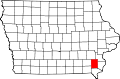
| County | Henry |
| Area | |
• Total | 2.31 sq mi (5.97 km2) |
| • Land | 2.31 sq mi (5.97 km2) |
| • Water | 0 sq mi (0.00 km2) |
| Elevation | 735 ft (224 m) |
| Population (2020) | |
• Total | 99 |
| • Density | 43.0/sq mi (16.59/km2) |
| Time zone | UTC-6 (Central (CST)) |
| • Summer (DST) | UTC-5 (CDT) |
| ZIP codes | 52652 |
| FIPS code | 19-76800 |
| GNIS feature ID | 2804140 [2] |
Swedesburg is an unincorporated community and census-designated place (CDP) in northern Henry County, Iowa, United States. It was first listed as a CDP prior to the 2020 census.