
Dorogobuzh is a historic town and the administrative center of Dorogobuzhsky District in Smolensk Oblast, Russia, straddling the Dnieper River and located 125 kilometers (78 mi) east of Smolensk, the administrative center of the oblast. Population: 10,720 (2010 Census); 12,250 (2002 Census); 12,254 (1989 Soviet census).

Safonovo is a town and the administrative center of Safonovsky District in Smolensk Oblast, Russia, located on the Vopets River 102 kilometers (63 mi) northeast of Smolensk, the administrative center of the oblast. Population: 46,116 (2010 Census); 48,209 (2002 Census); 56,571 (1989 Soviet census).
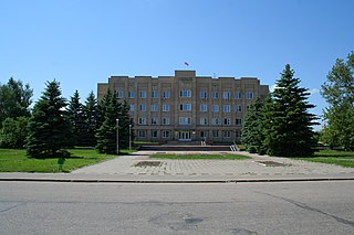
Pochinok is a town and the administrative center of Pochinkovsky District in Smolensk Oblast, Russia, located on the Khmara River 62 kilometers (39 mi) southeast of Smolensk, the administrative center of the oblast. Population: 8,776 (2010 Census); 9,578 (2002 Census); 10,753 (1989 Soviet census).

Dorogobuzhsky District is an administrative and municipal district (raion), one of the twenty-five in Smolensk Oblast, Russia. It is located in the center of the oblast. The area of the district is 1,771.99 square kilometers (684.17 sq mi). Its administrative center is the town of Dorogobuzh. Population: 29,077 ; 32,672 (2002 Census); 36,016 (1989 Soviet census). The population of Dorogobuzh accounts for 36.9% of the district's total population.

Dukhovshchinsky District is an administrative and municipal district (raion), one of the twenty-five in Smolensk Oblast, Russia. It is located in the north of the oblast and borders with Belsky District of Tver Oblast in the north, Kholm-Zhirkovsky District in the northeast, Yartsevsky District in the east, Kardymovsky District in the south, Smolensky District in the southwest, Demidovsky District in the west, and with Zharkovsky District of Tver Oblast in the northwest. The area of the district is 2,610.78 square kilometers (1,008.03 sq mi). Its administrative center is the town of Dukhovshchina. Population: 16,658 ; 19,182 (2002 Census); 23,720 (1989 Soviet census). The population of Dukhovshchina accounts for 42.4% of the district's total population.
Gagarinsky District is an administrative and municipal district (raion), one of the twenty-five in Smolensk Oblast, Russia. It is located in the northeast of the oblast. The area of the district is 2,904.59 square kilometers (1,121.47 sq mi). Its administrative center is the town of Gagarin. Population: 48,928 ; 46,401 (2002 Census); 21,978 (1989 Soviet census). The population of Gagarin accounts for 64.8% of the district's total population.
Kholm-Zhirkovsky District is an administrative and municipal district (raion), one of the twenty-five in Smolensk Oblast, Russia. It is located in the north of the oblast. The area of the district is 2,033.40 square kilometers (785.10 sq mi). Its administrative center is the urban locality of Kholm-Zhirkovsky. Population: 10,717 ; 12,815 (2002 Census); 15,966 (1989 Soviet census). The population of the administrative center accounts for 32.6% of the district's total population.
Monastyrshchinsky District is an administrative and municipal district (raion), one of the twenty-five in Smolensk Oblast, Russia. It is located in the west of the oblast and borders with Smolensky District in the north, Pochinkovsky District in the east, Khislavichsky District in the south, Mstsislaw District of Mogilev Region of Belarus in the west, and with Krasninsky District in the northwest. The area of the district is 1,513.75 square kilometers (584.46 sq mi). Its administrative center is the urban locality of Monastyrshchina. Population: 10,788 ; 13,876 (2002 Census); 17,559 (1989 Soviet census). The population of Monastyrshchino accounts for 37.7% of the district's total population.

Novoduginsky District is an administrative and municipal district (raion), one of the twenty-five in Smolensk Oblast, Russia. It is located in the northeast of the oblast. The area of the district is 1,922.04 square kilometers (742.10 sq mi). Its administrative center is the rural locality of Novodugino. Population: 10,477 ; 11,860 (2002 Census); 14,240 (1989 Soviet census). The population of Novodugino accounts for 36.6% of the district's total population.

Safonovsky District is an administrative and municipal district (raion), one of the twenty-five in Smolensk Oblast, Russia. It is located in the northern central part of the oblast. The area of the district is 2,258.46 square kilometers (872.00 sq mi). Its administrative center is the town of Safonovo. Population: 61,572 ; 65,251 (2002 Census); 17,115 (1989 Soviet census). The population of Safonovo accounts for 74.9% of the district's total population.

Sychyovsky District is an administrative and municipal district (raion), one of the twenty-five in Smolensk Oblast, Russia. It is located in the northeast of the oblast. The area of the district is 1,803.90 square kilometers (696.49 sq mi). Its administrative center is the town of Sychyovka. Population: 14,158 ; 15,835 (2002 Census); 18,847 (1989 Soviet census). The population of Sychyovka accounts for 57.3% of the district's total population.

Tyomkinsky District is an administrative and municipal district (raion), one of the twenty-five in Smolensk Oblast, Russia. It is located in the northeast of the oblast. The area of the district is 1,324.22 square kilometers (511.28 sq mi). Its administrative center is the rural locality of Tyomkino. Population: 6,348 ; 6,916 (2002 Census); 8,160 (1989 Soviet census). The population of the administrative center accounts for 38.0% of the district's total population.

Ugransky District is an administrative and municipal district (raion), one of the twenty-five in Smolensk Oblast, Russia. It is located in the east of the oblast. The area of the district is 2,868.52 square kilometers (1,107.54 sq mi). Its administrative center is the rural locality of Ugra. Population: 8,916 ; 11,022 (2002 Census); 14,005 (1989 Soviet census). The population of Ugra accounts for 48.0% of the district's total population.

Velizhsky District is an administrative and municipal district (raion), one of the twenty-five in Smolensk Oblast, Russia. It is located in the northwest of the oblast and borders with Vitebsk District, Vitebsk Region of Belarus in the west, Usvyatsky and Kunyinsky Districts of Pskov Oblast in the northwest, Zapadnodvinsky and Zharkovsky Districts of Tver Oblast in the northeast, Demidovsky District in the east, and with Rudnyansky District in the south. The area of the district is 1,473.19 square kilometers (568.80 sq mi). Its administrative center is the town of Velizh. Population: 12,248 ; 14,329 (2002 Census); 17,239 (1989 Soviet census). The population of Velizh accounts for 62.2% of the district's total population.

Vyazemsky District is an administrative and municipal district (raion), one of the twenty-five in Smolensk Oblast, Russia. It is located in the northeast of the oblast. The area of the district is 3,337.90 square kilometers (1,288.77 sq mi). Its administrative center is the town of Vyazma. Population: 80,436 ; 81,305 (2002 Census); 25,106 (1989 Soviet census). The population of Vyazma accounts for 71.0% of the district's total population.

Yartsevsky District is an administrative and municipal district (raion), one of the twenty-five in Smolensk Oblast, Russia. It is located in the central and northern parts of the oblast. The area of the district is 1,618.93 square kilometers (625.07 sq mi). Its administrative center is the town of Yartsevo. Population: 55,803 ; 62,012 (2002 Census); 10,767 (1989 Soviet census). The population of Yartsevo accounts for 85.7% of the district's total population.
Golynki is an urban-type settlement in Rudnyansky District of Smolensk Oblast, Russia. It is located on the banks of the Yelenka River. Population: 3,573 (2010 Census); 3,884 (2002 Census); 4,607 (1989 Soviet census).

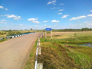
Monastyrshchina is an urban locality and the administrative center of Monastyrshchinsky District of Smolensk Oblast, Russia. It is located on the left bank of the Vikhra River, in the western part of the oblast. Population: 4,065 (2010 Census); 4,622 (2002 Census); 5,166 (1989 Soviet census).
Yershichi is a rural locality and the administrative center of Yershichsky District of Smolensk Oblast, Russia. It is located on the right bank of the Iput River. Population: 3,169 (2010 Census); 3,326 (2002 Census); 3,808 (1989 Soviet census).
Novodugino is a rural locality and the administrative center of Novoduginsky District, Smolensk Oblast, Russia. Population: 3,839 (2010 Census); 3,999 (2002 Census); 4,153 (1989 Soviet census).


