Demidov is a town and the administrative center of Demidovsky District in Smolensk Oblast, Russia, located on the Kasplya River at its confluence with the Gobza River. Population: 7,333 (2010 Census); 8,786 (2002 Census); 10,198 (1989 Census). It was previously known as Porechye.

Dukhovshchina is a town and the administrative center of Dukhovshchinsky District in Smolensk Oblast, Russia, located on the Vostitsa River 57 kilometers (35 mi) northeast of Smolensk, the administrative center of the oblast. Population: 4,371 (2010 Census); 4,683 (2002 Census); 5,747 (1989 Census).

Yelnya is a town and the administrative center of Yelninsky District in Smolensk Oblast, Russia, located on the Desna River, 82 kilometers (51 mi) from Smolensk, the administrative center of the oblast. Population: 10,095 (2010 Census); 10,798 (2002 Census); 9,868 (1989 Census).

Yartsevo is a town and the administrative center of Yartsevsky District in Smolensk Oblast, Russia, located on the Vop River, 63 kilometers (39 mi) northeast of Smolensk, the administrative center of the oblast. Population: 47,848 (2010 Census); 52,617 (2002 Census); 52,304 (1989 Census).
Krasny is an urban locality and the administrative center of Krasninsky District of Smolensk Oblast, Russia, located at the confluence of the Svinaya and the Mereya Rivers 67 kilometers (42 mi) southwest of Smolensk. Population: 4,349 (2010 Census); 4,714 (2002 Census); 5,087 (1989 Census).
Pechersk, also spelled Pechyorsk (Печёрск), is a rural locality in Smolensky District of Smolensk Oblast, Russia, located 7 kilometers (4.3 mi) north of Smolensk. Population: 3,884 (2010 Census); 3,750 (2002 Census); 4,067.

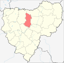
Krasninsky District is an administrative and municipal district (raion), one of the twenty-five in Smolensk Oblast, Russia. It is located in the west of the oblast and borders with Rudnyansky District in the north, Smolensky District in the east, Monastyrshchinsky District in the south, Horki District of Mogilev Region of Belarus in the southwest, and with Dubrowna District of Vitebsk Region, also of Belarus, in the west. The area of the district is 1,507.67 square kilometers (582.11 sq mi). Its administrative center is the urban locality of Krasny. Population: 12,895 ; 15,537 (2002 Census); 18,758 (1989 Census). The population of Krasny accounts for 33.7% of the district's total population.

Dorogobuzhsky District is an administrative and municipal district (raion), one of the twenty-five in Smolensk Oblast, Russia. It is located in the center of the oblast. The area of the district is 1,771.99 square kilometers (684.17 sq mi). Its administrative center is the town of Dorogobuzh. Population: 29,077 ; 32,672 (2002 Census); 36,016 (1989 Census). The population of Dorogobuzh accounts for 36.9% of the district's total population.

Dukhovshchinsky District is an administrative and municipal district (raion), one of the twenty-five in Smolensk Oblast, Russia. It is located in the north of the oblast. The area of the district is 2,610.78 square kilometers (1,008.03 sq mi). Its administrative center is the town of Dukhovshchina. Population: 16,658 ; 19,182 (2002 Census); 23,720 (1989 Census). The population of Dukhovshchina accounts for 42.4% of the district's total population.
Gagarinsky District is an administrative and municipal district (raion), one of the twenty-five in Smolensk Oblast, Russia. It is located in the northeast of the oblast. The area of the district is 2,904.59 square kilometers (1,121.47 sq mi). Its administrative center is the town of Gagarin. Population: 48,928 ; 46,401 (2002 Census); 21,978 (1989 Census). The population of Gagarin accounts for 64.8% of the district's total population.

Glinkovsky District is an administrative and municipal district (raion), one of the twenty-five in Smolensk Oblast, Russia. It lies in the center of the oblast and borders with Dorogobuzhsky District in the northeast, Yelninsky District in the southeast, Pochinkovsky District in the southwest, and with Kardymovsky District in the west. The area of the district is 1,225.74 square kilometers (473.26 sq mi). Its administrative center is the rural locality of Glinka. Population: 4,948 ; 6,149 (2002 Census); 7,866 (1989 Census).

Kardymovsky District is an administrative and municipal district (raion), one of the twenty-five in Smolensk Oblast, Russia. It is located in the center of the oblast. The area of the district is 1,093.15 square kilometers (422.07 sq mi). Its administrative center is the urban locality of Kardymovo. Population: 11,852 ; 12,521 (2002 Census); 13,505 (1989 Census). The population of Kardymovo accounts for 39.3% of the district's total population.
Kholm-Zhirkovsky District is an administrative and municipal district (raion), one of the twenty-five in Smolensk Oblast, Russia. It is located in the north of the oblast. The area of the district is 2,033.40 square kilometers (785.10 sq mi). Its administrative center is the urban locality of Kholm-Zhirkovsky. Population: 10,717 ; 12,815 (2002 Census); 15,966 (1989 Census). The population of the administrative center accounts for 32.6% of the district's total population.

Monastyrshchinsky District is an administrative and municipal district (raion), one of the twenty-five in Smolensk Oblast, Russia. It is located in the west of the oblast and borders with Smolensky District in the north, Pochinkovsky District in the east, Khislavichsky District in the south, Mstsislaw District of Mogilev Region of Belarus in the west, and with Krasninsky District in the northwest. The area of the district is 1,513.75 square kilometers (584.46 sq mi). Its administrative center is the urban locality of Monastyrshchina. Population: 10,788 ; 13,876 (2002 Census); 17,559 (1989 Census). The population of Monastyrshchino accounts for 37.7% of the district's total population.

Novoduginsky District is an administrative and municipal district (raion), one of the twenty-five in Smolensk Oblast, Russia. It is located in the northeast of the oblast. The area of the district is 1,922.04 square kilometers (742.10 sq mi). Its administrative center is the rural locality of Novodugino. Population: 10,477 ; 11,860 (2002 Census); 14,240 (1989 Census). The population of Novodugino accounts for 36.6% of the district's total population.

Safonovsky District is an administrative and municipal district (raion), one of the twenty-five in Smolensk Oblast, Russia. It is located in the northern central part of the oblast. The area of the district is 2,258.46 square kilometers (872.00 sq mi). Its administrative center is the town of Safonovo. Population: 61,572 ; 65,251 (2002 Census); 17,115 (1989 Census). The population of Safonovo accounts for 74.9% of the district's total population.

Sychyovsky District is an administrative and municipal district (raion), one of the twenty-five in Smolensk Oblast, Russia. It is located in the northeast of the oblast. The area of the district is 1,803.90 square kilometers (696.49 sq mi). Its administrative center is the town of Sychyovka. Population: 14,158 ; 15,835 (2002 Census); 18,847 (1989 Census). The population of Sychyovka accounts for 57.3% of the district's total population.

Tyomkinsky District is an administrative and municipal district (raion), one of the twenty-five in Smolensk Oblast, Russia. It is located in the northeast of the oblast. The area of the district is 1,324.22 square kilometers (511.28 sq mi). Its administrative center is the rural locality of Tyomkino. Population: 6,348 ; 6,916 (2002 Census); 8,160 (1989 Census). The population of the administrative center accounts for 38.0% of the district's total population.

Ugransky District is an administrative and municipal district (raion), one of the twenty-five in Smolensk Oblast, Russia. It is located in the east of the oblast. The area of the district is 2,868.52 square kilometers (1,107.54 sq mi). Its administrative center is the rural locality of Ugra. Population: 8,916 ; 11,022 (2002 Census); 14,005 (1989 Census). The population of Ugra accounts for 48.0% of the district's total population.

Vyazemsky District is an administrative and municipal district (raion), one of the twenty-five in Smolensk Oblast, Russia. It is located in the northeast of the oblast. The area of the district is 3,337.90 square kilometers (1,288.77 sq mi). Its administrative center is the town of Vyazma. Population: 80,436 ; 81,305 (2002 Census); 25,106 (1989 Census). The population of Vyazma accounts for 71.0% of the district's total population.