
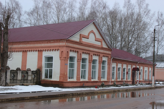
Demidov is a town and the administrative center of Demidovsky District in Smolensk Oblast, Russia, located on the Kasplya River at its confluence with the Gobza River. Population: 7,333 (2010 Russian census); 8,786 (2002 Census); 10,198 (1989 Soviet census). It was previously known as Porechye.

Rudnya is a town and the administrative center of Rudnyansky District in Smolensk Oblast, Russia, located on the Malaya Berezina River 68 kilometers (42 mi) northwest of Smolensk, the administrative center of the oblast. Population: 10,030 (2010 Russian census); 9,853 (2002 Census); 11,032 (1989 Soviet census).
Krasny is an urban locality and the administrative center of Krasninsky District of Smolensk Oblast, Russia, located at the confluence of the Svinaya and the Mereyka Rivers 67 kilometers (42 mi) southwest of Smolensk. Population: 4,349 (2010 Russian census); 4,714 (2002 Census); 5,087 (1989 Soviet census).

Przhevalskoye is an urban locality in Demidovsky District of Smolensk Oblast, Russia, located in the northwestern part of the oblast, on Lake Sapsho, northeast of the town of Demidov, the administrative center of the district. It is a terminus of the Demidov-Przhevalskoye Highway. As of the 2010 Census, its population was 1,683.

Krasninsky District is an administrative and municipal district (raion), one of the twenty-five in Smolensk Oblast, Russia. It is located in the west of the oblast and borders with Rudnyansky District in the north, Smolensky District in the east, Monastyrshchinsky District in the south, Horki District of Mogilev Region of Belarus in the southwest, and with Dubrowna District of Vitebsk Region, also of Belarus, in the west. The area of the district is 1,507.67 square kilometers (582.11 sq mi). Its administrative center is the urban locality of Krasny. Population: 12,895 ; 15,537 (2002 Census); 18,758 (1989 Soviet census). The population of Krasny accounts for 33.7% of the district's total population.

Demidovsky District is an administrative and municipal district (raion), one of the twenty-five in Smolensk Oblast, Russia. It is located in the northwest of the oblast and borders with Zharkovsky District of Tver Oblast in the north, Velizhsky District in the northwest, Rudnyansky District in the southwest, Smolensky District in the south, and with Dukhovshchinsky District in the east. The area of the district is 2,514.02 square kilometers (970.67 sq mi). Its administrative center is the town of Demidov. Population: 14,039 ; 18,167 (2002 Census); 24,237 (1989 Soviet census). The population of Demidov accounts for 52.2% of the district's total population.

Dorogobuzhsky District is an administrative and municipal district (raion), one of the twenty-five in Smolensk Oblast, Russia. It is located in the center of the oblast. The area of the district is 1,771.99 square kilometers (684.17 sq mi). Its administrative center is the town of Dorogobuzh. Population: 29,077 ; 32,672 (2002 Census); 36,016 (1989 Soviet census). The population of Dorogobuzh accounts for 36.9% of the district's total population.
Kholm-Zhirkovsky District is an administrative and municipal district (raion), one of the twenty-five in Smolensk Oblast, Russia. It is located in the north of the oblast. The area of the district is 2,033.40 square kilometers (785.10 sq mi). Its administrative center is the urban locality of Kholm-Zhirkovsky. Population: 10,717 ; 12,815 (2002 Census); 15,966 (1989 Soviet census). The population of the administrative center accounts for 32.6% of the district's total population.

Novoduginsky District is an administrative and municipal district (raion), one of the twenty-five in Smolensk Oblast, Russia. It is located in the northeast of the oblast. The area of the district is 1,922.04 square kilometers (742.10 sq mi). Its administrative center is the rural locality of Novodugino. Population: 10,477 ; 11,860 (2002 Census); 14,240 (1989 Soviet census). The population of Novodugino accounts for 36.6% of the district's total population.
Rudnyansky District is an administrative and municipal district (raion), one of the twenty-five in Smolensk Oblast, Russia. It is located in the west and northwest of the oblast and borders with Velizhsky District in the north, Demidovsky District in the northeast, Smolensky District in the east, Krasnensky District in the south, and with Vitebsk, Liozna, and Dubrowna Districts of Vitebsk Region of Belarus in the west. The area of the district is 2,111.41 square kilometers (815.22 sq mi). Its administrative center is the town of Rudnya. Population: 25,244 ; 28,037 (2002 Census); 34,724 (1989 Soviet census). The population of Rudnya accounts for 39.7% of the district's total population.

Safonovsky District is an administrative and municipal district (raion), one of the twenty-five in Smolensk Oblast, Russia. It is located in the northern central part of the oblast. The area of the district is 2,258.46 square kilometers (872.00 sq mi). Its administrative center is the town of Safonovo. Population: 61,572 ; 65,251 (2002 Census); 17,115 (1989 Soviet census). The population of Safonovo accounts for 74.9% of the district's total population.

Shumyachsky District is an administrative and municipal district (raion), one of the twenty-five in Smolensk Oblast, Russia. It is located in the southwest of the oblast and borders with Khislavichsky District in the north, Pochinkovsky District in the northwest, Roslavlsky District in the east, Yershichsky District in the southeast, Klimavichy District of Mogilev Region of Belarus in the south, and with Krychaw and Mstsislaw Districts, also of Mogilev Region, in the west. The area of the district is 1,367.70 square kilometers (528.07 sq mi). Its administrative center is the urban locality of Shumyachi. Population: 10,713 ; 14,032 (2002 Census); 17,678 (1989 Soviet census). The population of Shumyachi accounts for 39.5% of the district's total population.
Smolensky District is an administrative and municipal district (raion), one of the twenty-five in Smolensk Oblast, Russia. It is located in the west of the oblast and borders with Demidovsky District in the north, Dukhovshchinsky District in the northeast, Kardymovsky District in the east, Pochinkovsky District in the south, Monastyrshchinsky District in the southwest, Krasninsky District in the west, and with Rudnyansky District in the northwest. The area of the district is 2,494.98 square kilometers (963.32 sq mi). Its administrative center is the city of Smolensk. Population: 44,964 ; 47,281 (2002 Census); 50,620 (1989 Soviet census).

Tyomkinsky District is an administrative and municipal district (raion), one of the twenty-five in Smolensk Oblast, Russia. It is located in the northeast of the oblast. The area of the district is 1,324.22 square kilometers (511.28 sq mi). Its administrative center is the rural locality of Tyomkino. Population: 6,348 ; 6,916 (2002 Census); 8,160 (1989 Soviet census). The population of the administrative center accounts for 38.0% of the district's total population.

Ugransky District is an administrative and municipal district (raion), one of the twenty-five in Smolensk Oblast, Russia. It is located in the east of the oblast. The area of the district is 2,868.52 square kilometers (1,107.54 sq mi). Its administrative center is the rural locality of Ugra. Population: 8,916 ; 11,022 (2002 Census); 14,005 (1989 Soviet census). The population of Ugra accounts for 48.0% of the district's total population.

Velizhsky District is an administrative and municipal district (raion), one of the twenty-five in Smolensk Oblast, Russia. It is located in the northwest of the oblast and borders with Vitebsk District, Vitebsk Region of Belarus in the west, Usvyatsky and Kunyinsky Districts of Pskov Oblast in the northwest, Zapadnodvinsky and Zharkovsky Districts of Tver Oblast in the northeast, Demidovsky District in the east, and with Rudnyansky District in the south. The area of the district is 1,473.19 square kilometers (568.80 sq mi). Its administrative center is the town of Velizh. Population: 12,248 ; 14,329 (2002 Census); 17,239 (1989 Soviet census). The population of Velizh accounts for 62.2% of the district's total population.

Vyazemsky District is an administrative and municipal district (raion), one of the twenty-five in Smolensk Oblast, Russia. It is located in the northeast of the oblast. The area of the district is 3,337.90 square kilometers (1,288.77 sq mi). Its administrative center is the town of Vyazma. Population: 80,436 ; 81,305 (2002 Census); 25,106 (1989 Soviet census). The population of Vyazma accounts for 71.0% of the district's total population.
Yershichsky District is an administrative and municipal district (raion), one of the twenty-five in Smolensk Oblast, Russia. It is located in the south of the oblast and borders with Roslavlsky District in the north, Dubrovsky District of Bryansk Oblast in the east, Kletnyansky District, also of Bryansk Oblast, in the south, Khotsimsk District of Mogilev Region of Belarus in the southwest, Klimavichy District of Mogilev Region in the west, and with Shumyachsky District in the northwest. The area of the district is 1,039.00 square kilometers (401.16 sq mi). Its administrative center is the rural locality of Yershichi. Population: 7,102 ; 8,859 (2002 Census); 11,544 (1989 Soviet census). The population of Yershichi accounts for 44.6% of the district's total population.
Golynki is an urban-type settlement in Rudnyansky District of Smolensk Oblast, Russia. It is located on the banks of the Yelenka River. Population: 3,573 (2010 Russian census); 3,884 (2002 Census); 4,607 (1989 Soviet census).
Glinka is a rural locality and the administrative center of Glinkovsky District of Smolensk Oblast, Russia. Population: 1,942 (2010 Russian census); 2,017 (2002 Census); 2,283 (1989 Soviet census).


