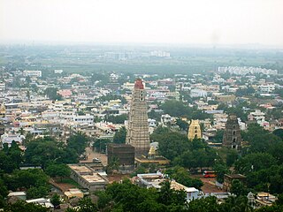
Mangalagiri is a major Sub-urban of Vijayawada in Guntur district of Indian state of Andhra Pradesh. The town is a part of Mangalagiri Tadepalli Municipal Corporation and part of Tenali revenue division. It and a part of Andhra Pradesh Capital Region. It is situated on National Highway 16 between Vijayawada and Guntur.

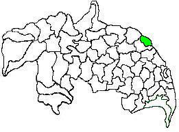
Guntur district is one of the twenty six districts in the Coastal Andhra region of the Indian state of Andhra Pradesh. The administrative seat of the district is located at Guntur, the largest city of the district in terms of area and with a population of 670,073. It has a coastline of approximately 100 km (62 mi) on the right bank of Krishna River, that separates it from Krishna district and NTR district. It is bounded on the south by Bapatla district and on the west by Palnadu district. It has an area of 2,443 km2 (943 sq mi), with a population of 20,91,075, as per 2011 census of India.
Bapatla is a town and district headquarters of Bapatla district in the Indian state of Andhra Pradesh. It is a municipality and the mandal headquarters of Bapatla mandal of Bapatla revenue division. The nearest towns and cities to Bapatla are Chirala, Ponnur, Tenali and Guntur of 17 km, 22 km, 50 km and 53 km respectively.
Narasaraopeta is a city and district headquarters of Palnadu District of the Indian state of Andhra Pradesh. The town is a municipality and mandal headquarters of Narasaraopet mandal and Headquarters of Narasaraopet revenue division. The town also is the seat of the court of Additional District Judge. Narasaraopet acts as a melting point for the Palnadu and Delta regions of the district. The town is also referred as the 'Gateway of Palnadu'. The main offices of Nagarjuna Sagar Jawahar Canal Operation & Maintenance Lingamguntla Circle are located in this town. Also it is considered as holy place.
Ponnur is a major city/town in Guntur district of the Indian state of Andhra Pradesh. A road to Chandole goes south-east and comes to Nidubrolu, where there is a temple with a stone bearing inscription recording the erection of 90 temple in A.D. 1132. An ancient Telugu manuscript entitled 'Ponnuru-Chandavolu Shasanam' was present in Potti Sreeramulu Telugu University. Kilari Venkata Rosaiah of YSRCP party is the current MLA of the constituency, who won the 2019 Andhra Pradesh Legislative Assembly election. It is a municipality and the mandal headquarter of Ponnur mandal under Tenali revenue division.

Repalle is a town in Bapatla district of the Indian state of Andhra Pradesh. The town is one of the 12 municipalities in Bapatla district and the headquarters of Repalle mandal under the administration of Repalle revenue division. It is situated near Krishna River in the Coastal Andhra region of the state.

Chirala, is a city in Bapatla district of the Indian state of Andhra Pradesh. It is a municipality and the headquarters of Chirala mandal in Chirala revenue division. As of 2011, it had a population of above 170,000.
Krishna Canal Junction railway station is an Indian Railways station in Tadepalle which is part of Mangalagiri Tadepalli Municipal Corporation and a satellite station of Vijayawada in Andhra Pradesh. It is administered by Vijayawada Railway Division of South Coast Railway zone and situated on New Delhi–Chennai, Howrah–Chennai main line. The station is the terminus for Guntur–Krishna Canal section. It is categorized as a Non-Suburban Grade-6 (NSG-6) station in the division. It is one of the 27 rural stations in the state to have Wi-Fi.

Duggirala is a village in Guntur district of the Indian state of Andhra Pradesh. It is the mandal headquarters of Duggirala mandal in Tenali revenue division. It is one of the major turmeric trading centres in the country.
Chilakaluripet is a city in Palnadu district of the Indian state of Andhra Pradesh. It is the Mandal headquarters of Chilakaluripet Mandal in Narasaraopet Revenue Division.

Pedavadlapudi is a village in Guntur district of the Indian state of Andhra Pradesh. It is in Mangalagiri mandal. It is part of Mangalagiri Tadepalle Municipal Corporation It is part of Guntur revenue division.

Mellempudi is a village or gram panchayat in Tadepalle mandal, Guntur district, Andhra Pradesh, India which is part of Mangalagiri Tadepalle Municipal Corporation with the postal identification number 522303. The nearest landmarks of this village includes the KL University.
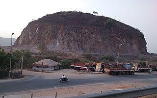
Kolanukonda is a suburb of Vijayawada in Guntur district of the Indian state of Andhra Pradesh. It is located in Tadepalle mandal part of Mangalagiri Tadepalle Municipal Corporation part of Guntur revenue division. There is a historical temple on the hill here. It is a Shiva temple and kodanda ramalayam and malchaamma Zenda chettu in tanda

Mangalagiri mandal is one of the 18 mandals in Guntur district of the Indian state of Andhra Pradesh. It is under the administration of Tenali revenue division and the headquarters are located at Mangalagiri town part of Mangalagiri Tadepalli Municipal Corporation. The mandal is bounded by Thullur, Tadepalle, Tadikonda, Pedakakani and Duggirala mandals and a portion of the mandal lies on the banks of Krishna River.
Tadepalle mandal is one of the 18 mandals in Guntur district of the Indian state of Andhra Pradesh. It is under the administration of Tenali revenue division and the headquarters are located at Tadepalle town. The mandal is situated on the banks of Krishna River, bounded by Thullur and Mangalagiri mandals. from the mandal are under the jurisdiction of Andhra Pradesh Capital City.

Chinakakani is a village in Guntur district of the Indian state of Andhra Pradesh. It is located in Mangalagiri mandal part of Mangalagiri Tadepalle Municipal Corporation part of Guntur revenue division.
Vaddeswaram is a census town in Guntur district of the Indian state of Andhra Pradesh. It is located at a distance of 5 km (3.1 mi) from Krishna River, in Tadepalle mandal part of Mangalagiri Tadepalle Municipal Corporation part of Guntur revenue division.

Penumaka is a part of Mangalagiri Tadepalle Municipal Corporation part of Guntur district which is part of Andhra Pradesh. It was a village in Tadepalle mandal of Guntur district, prior to its de–notification as gram panchayat.
Mangalagiri Tadepalli Municipal Corporation is the local self government in Mangalagiri, Tadepalle towns of the Indian state of Andhra Pradesh. It is classified as a Municipal Corporation.
Mangalagiri Tadepalli Municipal Corporation (MTMC) is the civic body that governs Mangalagiri and Tadepalle city's and villages in the corresponding mandals of the Mangalagiri Assembly constituency in Guntur district of Andhra Pradesh. It is the second largest municipal corporation next in line to GVMC in terms of area with 194.41 km2 (75.06 sq mi) and 2,53,875 of voters in the state of Andhra Pradesh. It is classified as important Municipal Corporation in the Capital of Andhra Pradesh. Municipal Corporation mechanism in India was introduced during British Rule with formation of municipal corporation in Madras (Chennai) in 1688, later followed by municipal corporations in Bombay (Mumbai) and Calcutta (Kolkata) by 1762. Mangalagiri Tadepalli Municipal Corporation Municipal Corporation is headed by Mayor of city and governed by Commissioner.

