Tago River

Last updated
Tago River
Philippines relief location map (Mindanao).svg
Red pog.svg
Tago River mouth
Philippines relief location map (square).svg
Red pog.svg
Tago River (Philippines)
Native nameIlog Tago (Tagalog)
Location
Country Philippines
Region Caraga
Province Surigao del Sur
Municipality Sibagat, Tandag City, San Miguel, Tago
Physical characteristics
Source 
  location Sibagat, Agusan del Sur, Caraga Region
Mouth Philippine Sea
  location
Purisima (Poblacion), Tago, Surigao del Sur
  coordinates
9°01′16″N126°13′54″E / 9.02111°N 126.23167°E / 9.02111; 126.23167
Length19 km (12 mi)
Basin size35 km2 (14 sq mi)
Discharge 
  locationTago River
  average56 m3/s (2,000 cu ft/s)
Basin features
ProgressionTago River- Philippine Sea

The Tago River (Tagalog : Ilog Tago; Cebuano : Suba sa Tago; Surigaonon : Suba nan Tago) is a stream located in Sibagat, Agusan del Sur, and the municipalities of San Miguel and Tago, Surigao del Sur, Caraga Region, in northeastern Mindanao, in southern Philippines. [1]

Contents

Etymology

Tago is a Visayan term meaning "hide" or "hidden".

Geography

The Tago River is situated approximately 9.01555556, 126.24055556 in the island of Mindanao. [2] [3] The estimate terrain elevation above sea level is 1 metre. [1]

The Tago River headwaters from the Diwata Mountain Range in Sibagat, Agusan del Sur. It traverses along the barangays of Kolambugan and Padiay in Sibagat; the riverbank barangays of Bitaugan, Bagyang, Calatngan, Carromata, Sagbayan, Poblacion, Baras and Libas Gua (all in the municipality of San Miguel, Surigao del Sur); and barangays of Badong, Alba, Bangsud, Anahao Bag-o, Anahao Daan, Gamut, Camagong, Unaban, Unidos, Purisima (all in the municipality of Tago, Surigao del Sur) where its mouth located in Barangay Poblacion meet with the Philippine Sea of the Western Pacific Ocean.

The Tago River also serves as boundaries that separates the municipalities of Tago and Bayabas, Surigao del Sur, as well as Tago and Tandag City. [4]

Tago River basin

The Tago River basin is composed of the province of Surigao del Sur and Agusan del Sur in Mindanao. It lies at 125°43’ to 126°16’ east longitude and 8°44’ to 9°11’ north latitude. It traverses the municipality of Sibagat of Agusan del Sur and the municipalities of Cantilan, Lanuza, Tandag City, San Miguel, Cagwait, and Tago of Surigao del Sur. The basin has an estimated drainage area of 1,448 square kilometers, and is about 50 kilometers long and 60 kilometers wide. [5]

The Tago River is the principal drainageway of the basin. It originates in the City of Cabadbaran, Agusan del Norte, and the municipality of Sibagat, Agusan del Sur, and traverses the entire length of the basin in an easterly direction and discharges into the Philippine Sea. The river channel is wide and is navigable by motorboats up to about 45 kilometers from its outlet. Several tributaries, such as the Maitum and Umalag Rivers that pass Barangay Poblacion in San Miguel, Surigao del Sur, and the Bagyang River, which traverses from Barangay Bitaugan down to Barangay Calatngan of the same municipality, contribute directly to the Tago River. [5]

Watershed

The Tago River Watershed, covering a total area of 143,770 hectares, has its Headwaters originating from the northwestern portion of Diwata Mountain Range located in Sibagat in the Province of Agusan del Sur. Its major tributaries are the Agasan River, Calatngan River, Baroboan River, Umalag River and Suba River. Among the more prominent flowing creeks/tributaries are the Malagdao Creek, Malitbog Creek, Bato Creek, Dioco Creek, Bacnalon Creek, Balancanadan Creek, Pajo Creek, Bakaka-an Creek, Bitaugan Creek, Cadilotan Creek, and Enadan Creek. [6]

Following a southeasterly direction,the Tago Riverenters the SUDECOR area at the midsection of the western boundary where it drains an area of more than 35,500 ha. From there, along its sinuous course, the Tago River is fed with waters of Agasan, Calatngan, Baroboan, and Suba River draining the northwestern, central, southwestern and southeastern part, respectively. Shortly after leaving the main forest concession and upon reaching the flood plains of San Miguel, the waters draining from the Tago River and its tributaries are tapped by a National Irrigation Administration (NIA) diversion dam for irrigating some 14,000-ha of rice fields in the San MiguelTago area. About 9 km further downstream, the Tago River the water of the Suba River that drains the southeastern part, thence the river continues eastward until it reaches the Philippine Sea near the town of Tago, Surigao del Sur. [6]

See also

Related Research Articles

<span class="mw-page-title-main">Surigao del Norte</span> Province in Caraga, Philippines

Surigao del Norte, officially the Province of Surigao del Norte, is a province in the Philippines located in the Caraga region of Mindanao. The province was formerly under the jurisdiction of Region 10 until 1995. Its capital is Surigao City. The province comprises two major islands—Siargao and Bucas Grande—in the Philippine Sea, plus a small area at the northeastern tip of mainland Mindanao and other surrounding minor islands and islets. This mainland portion borders Agusan del Norte – between the Municipality of Alegria in Surigao del Norte and the Municipality of Kitcharao in Agusan del Norte; and the province of Surigao del Sur, to the south.

<span class="mw-page-title-main">Surigao del Sur</span> Province in Caraga, Philippines

Surigao del Sur, officially the Province of Surigao del Sur, is a province in the Philippines located in the Caraga region in Mindanao. Its capital is Tandag City. Surigao del Sur is situated at the eastern coast of Mindanao and faces the Philippine Sea to the east.

<span class="mw-page-title-main">Tandag</span> Capital of Surigao del Sur, Philippines

Tandag, officially the City of Tandag, is a 5th class component city and capital of the province of Surigao del Sur, Philippines. According to the 2020 census, it has a population of 62,669 people.

<span class="mw-page-title-main">Sibagat</span> Municipality in Agusan del Sur, Philippines

Sibagat, officially the Municipality of Sibagat, is a 1st class municipality in the province of Agusan del Sur, Philippines. According to the 2020 census, it has a population of 33,957 people.

<span class="mw-page-title-main">Bislig</span> Component city in Surigao del Sur, Philippines

Bislig, officially the City of Bislig, is a 3rd class component city in the province of Surigao del Sur, Philippines. According to the 2020 census, it has a population of 99,290 people.

<span class="mw-page-title-main">Cantilan</span> Municipality in Surigao del Sur, Philippines

Cantilan, officially the Municipality of Cantilan, is a 2nd class municipality in the province of Surigao del Sur, Philippines. According to the 2020 census, it has a population of 34,060 people.

<span class="mw-page-title-main">Bayugan</span> Component city in Agusan del Sur, Philippines

Bayugan, officially the City of Bayugan, is a 5th class component city in the province of Agusan del Sur, Philippines. According to the 2020 census, it has a population of 109,499 people..

<span class="mw-page-title-main">San Francisco, Agusan del Sur</span> Municipality in Agusan del Sur, Philippines

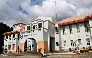
San Francisco, officially the Municipality of San Francisco, is a 1st class municipality in the province of Agusan del Sur, Philippines. According to the 2020 census, it has a population of 80,760 people.

<span class="mw-page-title-main">Surigao City</span> Capital of Surigao del Norte, Philippines

Surigao City, officially the City of Surigao, is a 1st class component city and capital of the province of Surigao del Norte, Caraga Region, on the north-eastern island of Mindanao, Philippines.

<span class="mw-page-title-main">Barobo</span> Municipality in Surigao Del Sur, Philippines

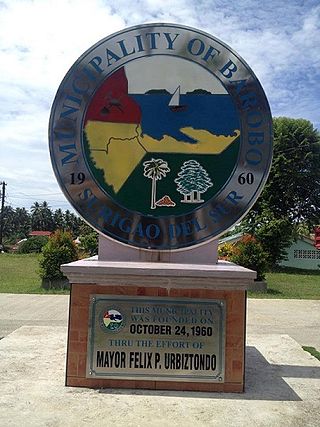
Barobo, officially the Municipality of Barobo is a 3rd class municipality in the province of Surigao del Sur, Philippines. According to the 2020 census, it has a population of 53,146 people.

<span class="mw-page-title-main">Cagwait</span> Municipality in Surigao del Sur, Philippines

Cagwait, officially the Municipality of Cagwait, is a 4th class municipality in the province of Surigao del Sur, Philippines. According to the 2020 census, it has a population of 21,747 people.

<span class="mw-page-title-main">Lianga</span> Municipality in Surigao del Sur, Philippines

Lianga, officially the Municipality of Lianga, is a 4th class municipality in the province of Surigao del Sur, Philippines. According to the 2020 census, it has a population of 33,869 people.

<span class="mw-page-title-main">Tago, Surigao del Sur</span> Municipality in Surigao del Sur, Philippines

Tago, officially the Municipality of Tago, is a 2nd class municipality in the province of Surigao del Sur, Philippines. According to the 2020 census, it has a population of 39,831 people.

The Wawa River is a river located in Caraga, in northeastern Mindanao, in the southern Philippine island. Its headwaters traverse the municipality of Sibagat, Bayugan, and Esperanza. The Wawa River is a tributary of the larger Agusan River.

<span class="mw-page-title-main">Pinandagatan Falls</span> Waterfall in Agusan del Sur, Philippines

Pinandagatan Falls is located in the far-flung barangay of New Tubigon, Sibagat, Agusan del Sur in the southern Philippine island of Mindanao. It is one of the tourist attractions of Sibagat, Agusan del Sur.

<span class="mw-page-title-main">Sibagat River</span> River in Caraga, Philippines

The Sibagat River is a stream located in Sibagat, Agusan del Sur, Caraga Region, Philippines. It is a tributary of the larger Wawa River with headwaters located in the northeastern mountain boundaries of Sibagat and Butuan.

Managong Falls is known to be the biggest and tallest waterfalls in the province of Agusan del Sur. Located in barangay Padiay in the municipality of Sibagat, Agusan del Sur, Caraga Region, in the southern Philippine island of Mindanao, is one of the tourist attractions and ecotourism sites of Sibagat.

The Tambagoko River is a stream located in Sibagat, Agusan del Sur, Caraga Region, Philippines. It is a tributary of the Sibagat River with headwaters located in the hinterlands of Barangays Perez and Sta. Cruz.

The Andanan River is a stream located in Sibagat, Agusan del Sur and Bayugan, Caraga Region, Philippines. It is a tributary of the larger Wawa River.

The Boguko River is a stream located in Sibagat, Agusan del Sur, Caraga Region, Philippines. It is a tributary of the larger Wawa River with headwaters located in the mountain boundaries of Sibagat and the Province of Surigao del Sur.

References

  1. 1 2 "Tago River stream, Caraga, Philippines". ph.geoview.info. Retrieved 2021-04-17.
  2. "Mindat.org". www.mindat.org. Retrieved 2021-04-17.
  3. "Tago River, Philippines - Geographical Names, map, geographic coordinates". geographic.org. Retrieved 2021-04-17.
  4. Mordeno, H. Marcos (2017-12-05). "A View of Tago River from Tandag City".{{cite journal}}: Cite journal requires |journal= (help)
  5. 1 2 Paringit, Enrico C. Dr. Eng; Makinano - Santillan, Meriam (2017-07-01). "LiDAR Surveys and Flood Mapping of Tago River" (PDF). Hazard Mapping of the Philippines Using LIDAR (Phil-LIDAR 1): 1.
  6. 1 2 Sustainable Ecosystem International Corp. "Integration of Forest Management Units (FMU) into a Sustainable Development Unit (SDU) through Collaborative Forest Management in Surigao del Sur (Tago Watershed)" (PDF). Collaborative Framework for Sustainable Forest Management in the East Diwata SDU. PD 167/02 Rev. 2 (F): 16.