
The Ordovician is a geologic period and system, the second of six periods of the Paleozoic Era. The Ordovician spans 41.6 million years from the end of the Cambrian Period 485.4 million years ago (Mya) to the start of the Silurian Period 443.8 Mya.
The Franklin Mountains of New Zealand are a group of peaks in the southwestern area of the South Island, located between Bligh Sound and Lake Te Anau, within Fiordland National Park.

The Torlesse Composite Terrane is a plate tectonic terrane forming part of the South Island of New Zealand. It contains the Rakaia, Aspiring and Pahau Terranes and the Esk Head Belt. Greywacke is the dominant rock type of the composite terrane; argillite is less common and there are minor basalt occurrences. The Torlesse Composite Terrane is found east of the Alpine Fault in the Southern Alps of New Zealand. Its southern extent is a cryptic boundary with the Caples Terrane within the Haast Schists in Central Otago. It is named for the Torlesse Range in Canterbury.

The Haast Schist, which contains both the Alpine and Otago Schist, is a metamorphic unit in the South Island of New Zealand. It extends from Central Otago, along the eastern side of the Alpine Fault to Cook Strait. There are also isolated outcrops of the Haast Schist within the central North Island. The schists were named after Haast Pass on the West Coast. The Haast Schist can be divided geographically from north to south into the Kaimanawa, Terawhiti, Marlborough, Alpine, Otago and Chatham schist.
The Lachlan Fold Belt (LFB) or Lachlan Orogen is a geological subdivision of the east part of Australia. It is a zone of folded and faulted rocks of similar age. It dominates New South Wales and Victoria, also extending into Tasmania, the Australian Capital Territory and Queensland. It was formed in the Middle Paleozoic from 450 to 340 Mya. It was earlier known as Lachlan Geosyncline. It covers an area of 200,000 km2.

The geology of New Zealand is noted for its volcanic activity, earthquakes and geothermal areas because of its position on the boundary of the Australian Plate and Pacific Plates. New Zealand is part of Zealandia, a microcontinent nearly half the size of Australia that broke away from the Gondwanan supercontinent about 83 million years ago. New Zealand's early separation from other landmasses and subsequent evolution have created a unique fossil record and modern ecology.
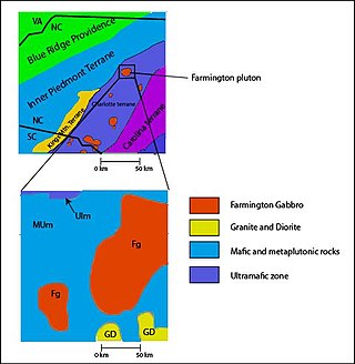
The Carolina Terrane, also called the Carolina Superterrane or Carolinia, is an exotic terrane running ~370 miles (600 km) approximately North-South from central Georgia to central Virginia in the United States. It constitutes a major part of the eastern Piedmont Province.
The Huriwai River is a river of about 9 km (5.6 mi) in New Zealand's North Island. It rises in rough hill country to the southeast of Port Waikato, flowing west to reach the Tasman Sea 5 kilometres (3 mi) south of the mouth of the Waikato River. The main tributary is the Mangapai Stream.

The Tasman Region, and the small adjoining Nelson Region, form one of the more geologically interesting regions of New Zealand. It contains the oldest rocks of anywhere on New Zealand's main islands. It contains all the main terranes that make up New Zealand's basement. These basement rocks include Ultramafic rocks, such as Serpentine and Dunite, and valuable minerals, such as Gold. The Nelson Region is bordered to the south by the Alpine Fault, the main fault forming the boundary between the Pacific Plate and the Indo-Australian Plate, that generated the Southern Alps.

Mount Arthur is in the Wharepapa / Arthur Range in the north western area of the South Island of New Zealand. Mount Arthur, named after Captain Arthur Wakefield, lies within Kahurangi National Park and has a peak elevation of 1,795 metres (5,889 ft).
Kakepuku is a volcanic cone which rises from the plain between the Waipā and Puniu rivers, about 3 km (2 mi) NW of Te Kawa and 8 km (5 mi) SW of Te Awamutu in the Waikato region of New Zealand's North Island.
The Dun Mountain-Maitai Terrane comprises the Dun Mountain Ophiolite Belt, Maitai Group and Patuki Mélange. The Dun Mountain Ophiolite is an ophiolite of Permian age located in New Zealand's South Island. Prehistorically this ophiolite was quarried by Māori for both metasomatized argillite and pounamu (jade) which was used in the production of tools and jewellery.

This is a list of the units into which the rock succession of New Zealand is formally divided. As new geological relationships have been discovered new names have been proposed and others are made obsolete. Not all these changes have been universally adopted. This table is based on the 2014 New Zealand Stratigraphic Lexicon (Litho2014). However, obsolete names that are still in use and names postdating the lexicon are included if it aids in understanding.

The Banks Peninsula Volcano is an extinct volcanic complex to the east of Christchurch on New Zealand's South Island. While the volcano is highly eroded it still forms the majority of Banks Peninsula with a highest point of 919 m (3,015 ft). It is a composite of two main eruptive centres one originating at Lyttelton Harbour, the other at Akaroa Harbour. The eruptions were predominantly basaltic, with associated andesite and trachytes, with minor rhyolite. The volcanic activity occurred in the Late Miocene and possibly extended into the Early Pliocene. There are four volcanic groups, all of which are within the Māui Supergroup. The Christchurch earthquakes led to rumors of a possible eruption, however, there is no known magma chamber beneath the volcano and there has not been any sign of volcanic activity in the last 5 million years.

The geology of the West Coast of New Zealand's South Island is divided in two by the Alpine Fault, which runs through the Region in a North-East direction. To the West of the fault Paleozoic basement rocks are interluded by plutones and both are unconformably covered in a sedimentary sequence. To the East of the Alpine Fault are the Mesozoic Alpine Schist and Greywacke of the Southern Alps. There are numerous active faults throughout the region.

The Southland Syncline is a major geological structure located in the Southland Region of New Zealand's South Island. The syncline folds the Mesozoic greywackes of the Murihiku Terrane. The northern limb of the fold is steep to overturned, while the southern limb dips shallowly to the northeast. The axial plan dips to the northeast and the axis plunges to the southeast.

The Waitemata Group is an Early Miocene geologic group that is exposed in and around the Auckland Region of New Zealand, between the Whangarei Harbour in the North and the Raglan Harbour in the South. The Group is predominantly composed of deep water sandstone and mudstone (flysch). The sandstone dominated units form the cliffs around the Waitemata Harbour and rare more resistant conglomerates underlie some of Auckland's prominent ridges.
Roger Alan Cooper was a New Zealand paleontologist, known as a leading expert on the fossil zooplankton of the early Paleozoic and the paleobiology of Zealandia.
The Waitākere volcano, also known as the Manukau volcano, was a Miocene era volcano that formed off the west coast of the modern Auckland Region of New Zealand's North Island. Erupting intermittently between 23 million and 15 million years ago, the volcano was at one point one of the tallest mountains in New Zealand. The volcano alternated between periods as a seamount and as a volcanic island, before tectonic forces raised the volcano up from the seafloor 17 million years ago. Volcanism at the site ceased 15 million years ago and the cone has mostly eroded, however the modern Waitākere Ranges are formed from the remnants of the volcano's eastern slopes. A number of visible volcanic sites associated with the Waitākere volcano remain around Auckland, including Pukematekeo, Karekare and Lion Rock.

