Tangalan Last updated January 08, 2026 Municipality in Aklan, Philippines
Municipality in Western Visayas, Philippines
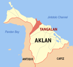
Tangalan , officially the Municipality of Tangalan (Aklanon : Banwa it Tangalan ; Hiligaynon : Banwa sang Tangalan ; Tagalog : Bayan ng Tangalan municipality in the province of Aklan , Philippines . According to the 2024 census, it has a population of 24,004 people. [ 5]
History Tangalan was formerly an arrabal of Makato . At the time of its creation, it included the following barrio s: Tondog, Jawili, Dumatad, Afga, Baybay, Dapdap, Pudyot, Tagas, Tamalagon, Panayakan, Vivo, Lanipga, Napatag and Tamokoe. [ 6]
Geography Tangalan is located at 11°46′39″N 122°15′37″E / 11.7775°N 122.2603°E / 11.7775; 122.2603 18 kilometres (11 mi) from Kalibo , the provincial capital.
According to the Philippine Statistics Authority , the municipality has a land area of 74.59 square kilometres (28.80 sq mi) [ 7] constituting 4.10% of the 1,821.42-square-kilometre- (703.25 sq mi) total area of Aklan.
Climate Climate data for Tangalan, Aklan Month Jan Feb Mar Apr May Jun Jul Aug Sep Oct Nov Dec Year Mean daily maximum °C (°F) 28 29 30 32 32 31 30 29 29 29 29 28 30 Mean daily minimum °C (°F) 23 23 23 24 25 25 25 24 24 24 24 23 24 Average precipitation mm (inches) 47 33 39 48 98 150 169 147 163 172 118 80 1,264 Average rainy days 11.4 8.2 9.3 9.7 19.1 25.6 27.4 25.5 25.5 25.2 18.5 14.5 219.9 Source: Meteoblue [ 8]
Barangays Tangalan is politically subdivided into 15 barangays . [ 9] Each barangay consists of puroks and some have sitios .
PSGC Barangay Population ±% p.a. 2024 [ 10] 2010 [ 11] 060417001 Afga 6.7% 1,612 1,472 ▴ 0.67% 060417002 Baybay 6.7% 1,597 1,582 ▴ 0.07% 060417003 Dapdap 4.3% 1,042 966 ▴ 0.55% 060417004 Dumatad 4.7% 1,130 1,051 ▴ 0.53% 060417005 Jawili 7.6% 1,822 1,732 ▴ 0.37% 060417006 Lanipga 1.4% 330 312 ▴ 0.41% 060417007 Napatag 0.9% 224 280 ▾ −1.62% 060417008 Panayakan 13.0% 3,116 2,684 ▴ 1.10% 060417009 Poblacion 6.3% 1,516 1,429 ▴ 0.43% 060417010 Pudiot 7.6% 1,828 1,617 ▴ 0.90% 060417011 Tagas 10.0% 2,407 2,017 ▴ 1.30% 060417012 Tamalagon 10.9% 2,609 2,497 ▴ 0.32% 060417013 Tamokoe 0.6% 154 228 ▾ −2.83% 060417014 Tondog 8.1% 1,955 1,745 ▴ 0.83% 060417015 Vivo 2.4% 574 665 ▾ −1.07% Total 24,004 20,277 ▴ 1.24%
Demographics Population census of Tangalan Year ±% p.a. 1903 3,009 — 1948 6,765 +1.82% 1960 7,650 +1.03% 1970 9,987 +2.70% 1975 10,509 +1.03% 1980 11,174 +1.23% 1990 14,773 +2.83% 1995 16,172 +1.71% 2000 17,606 +1.84% 2007 19,121 +1.15% 2010 20,277 +2.16% 2015 21,916 +1.49% 2020 23,704 +1.66% 2024 24,004 +0.30% Source: Philippine Statistics Authority [ 12] [ 13] [ 11] [ 14] [ 15]
In the 2024 census, Tangalan had a population of 24,004 people. [ 16] The population density was 320 inhabitants per square kilometre (830/sq mi) .
Tourism Jawili Falls Tourist spots with government support under "Project Bugna" include Jawili Falls, Jawili Beach Resorts, Dumatad Souvenir Shop, and Bughawi Reforestation Project.
The Tangalan Marine Sanctuary covers 375 hectares (930 acres) of marine ecosystem and a 10 hectares (25 acres) coral garden.
Education The Tangalan Schools District Office governs all educational institutions within the municipality. It oversees the management and operations of all private and public, from primary to secondary schools. [ 25]
Primary and elementary schools Baybay Elementary School Dapdap Elementary School Dumatad Elementary School Juan B. Molo-Afga Elementary School Lanipga-Napatag Primary School Panayakan Elementary School Sergio L. Taligatos Elementary School Tagas Elem. School Tangalan Elementary School Tondog Elementary School Vivo Integrated School Secondary schools Jawili Integrated School Panayakan National High School Tamalagon Integrated School Tangalan National High School Vivo Integrated School References ↑ Municipality of Tangalan | (DILG) ↑ "2015 Census of Population, Report No. 3 – Population, Land Area, and Population Density" (PDF) . Philippine Statistics Authority . Quezon City, Philippines. August 2016. ISSN 0117-1453 . Archived (PDF) from the original on May 25, 2021. Retrieved July 16, 2021 . ↑ "2024 Census of Population (POPCEN) Population Counts Declared Official by the President" . Philippine Statistics Authority. 17 July 2025. Retrieved 18 July 2025 . ↑ "PSA Releases the 2021 City and Municipal Level Poverty Estimates" . Philippine Statistics Authority. 2 April 2024. Retrieved 28 April 2024 . ↑ "2024 Census of Population (POPCEN) Population Counts Declared Official by the President" . psa.gov.ph . July 17, 2024. Retrieved November 24, 2025 . ↑ "Republic Act No. 285; An Act Creating the Municipality of Tangalan in the Province of Capiz" . The Corpus Juris . 16 June 1948. Retrieved 22 October 2016 . ↑ "Province: Aklan" . PSGC Interactive . Quezon City, Philippines: Philippine Statistics Authority . Retrieved 25 August 2025 . ↑ "Tangalan: Average Temperatures and Rainfall" . Meteoblue. Retrieved 1 May 2020 . ↑ "Municipal: Tangalan" . PSGC Interactive . Quezon City, Philippines: Philippine Statistics Authority . Retrieved 8 January 2016 . ↑ Census of Population (2020). "Region VI (Western Visayas)" . Total Population by Province, City, Municipality and Barangay . Philippine Statistics Authority . Retrieved 8 July 2021 . 1 2 Census of Population and Housing (2010). "Region VI (Western Visayas)" (PDF) . Total Population by Province, City, Municipality and Barangay . National Statistics Office . Retrieved 29 June 2016 . ↑ "2024 Census of Population (POPCEN) Population Counts Declared Official by the President" . Philippine Statistics Authority. 17 July 2025. Retrieved 18 July 2025 . ↑ Census of Population (2015). "Region VI (Western Visayas)" . Total Population by Province, City, Municipality and Barangay . Philippine Statistics Authority . Retrieved 20 June 2016 . ↑ Censuses of Population (1903–2007). "Region VI (Western Visayas)" . Table 1. Population Enumerated in Various Censuses by Province/Highly Urbanized City: 1903 to 2007 National Statistics Office . ↑ "Province of Aklan" . Municipality Population Data . Local Water Utilities Administration Research Division. Retrieved 17 December 2016 . ↑ "2024 Census of Population (POPCEN) Population Counts Declared Official by the President" . Philippine Statistics Authority. 17 July 2025. Retrieved 18 July 2025 . ↑ "Poverty incidence (PI):" . Philippine Statistics Authority. Retrieved December 28, 2020 . ↑ "Estimation of Local Poverty in the Philippines" (PDF) . Philippine Statistics Authority. 29 November 2005. ↑ "2003 City and Municipal Level Poverty Estimates" (PDF) . Philippine Statistics Authority. 23 March 2009. ↑ "City and Municipal Level Poverty Estimates; 2006 and 2009" (PDF) . Philippine Statistics Authority. 3 August 2012. ↑ "2012 Municipal and City Level Poverty Estimates" (PDF) . Philippine Statistics Authority. 31 May 2016. ↑ "Municipal and City Level Small Area Poverty Estimates; 2009, 2012 and 2015" . Philippine Statistics Authority. 10 July 2019. ↑ "PSA Releases the 2018 Municipal and City Level Poverty Estimates" . Philippine Statistics Authority. 15 December 2021. Retrieved 22 January 2022 . ↑ "PSA Releases the 2021 City and Municipal Level Poverty Estimates" . Philippine Statistics Authority. 2 April 2024. Retrieved 28 April 2024 . ↑ "Masterlist of Schools" (PDF) . Department of Education . January 15, 2021. Retrieved November 24, 2025 . External links Wikimedia Commons has media related to
Tangalan .
Places adjacent to Tangalan
This page is based on this
Wikipedia article Text is available under the
CC BY-SA 4.0 license; additional terms may apply.
Images, videos and audio are available under their respective licenses.