Makato Last updated January 08, 2026 Municipality in Aklan, Philippines
Not to be confused with
Makati .
Municipality in Western Visayas, Philippines
Makato
Taft
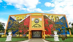
Municipality of Makato Makato Sports Complex
Flag
Seal
Nickname: Blooming Makato
Motto: Hala Bira sa Progreso
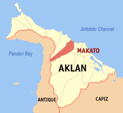
Map of Aklan with Makato highlighted
Interactive map of Makato
Coordinates: 11°42′43″N 122°17′32″E / 11.712°N 122.2922°E / 11.712; 122.2922 Country Philippines Region Western Visayas Province Aklan District 2nd district Barangays Barangays ) • Type Sangguniang Bayan • Mayor Ramon Anselmo Martin D. Legaspi III • Vice Mayor Leoncito Y. Mationg • Representative Teodorico T. Haresco Jr. • Municipal Council
Nilo M. Amboboyog Marlene Mae Blaire T. Igham Nerli F. dela Cena Randy R. Vargas Rhine I. Roldan Abencio Honeyboy P. Torres III Leoncito Y. Mationg Steven M. Tejada • Electorate 23,128 voters (2025 ) • Total
64.60 km2 (24.94 sq mi) Elevation
52 m (171 ft) Highest elevation
1,070 m (3,510 ft) Lowest elevation
0 m (0 ft) • Total
30,650 • Density474.5/km2 (1,229/sq mi) • Households
7,394 • Income class 4th municipal income class • Poverty incidence % (2021) [ 4] • Revenue ₱ 95,616,098.46 [ 5] • Appropriations ₱98,469,786.02 [ 6] • Assets ₱245,439,688.82 [ 7] • Liabilities ₱42,440,665,26 [ 8] • Expenditure ₱87,558,602.68 [ 9] • Obligation's ₱98,469,786.02 [ 10] • ElectricityAklan Electric Cooperative (AKELCO) Time zone UTC+8 (PST ) ZIP code 5611
PSGC IDD area code +63 (0)36 Native languages Aklanon Patron saint Santo Niño Website www
Makato , officially the Municipality of Makato (Aklanon : Banwa it Makato ; Hiligaynon : Banwa sang Makato ; Tagalog : Bayan ng Makato municipality in the province of Aklan , Philippines . According to the 2024 census, it has a population of 30,650 people. [ 11]
The town is the home of the Ati-Atihan Festival , a historic celebration that attracts devotees from across the Philippines and abroad to honor Sto. Niño through vibrant cultural and religious activities. [ 12]
History Established in the thirteenth century, the town’s name had been acquired by accident. Thinking that the Spaniards came to ask the route along the river, the native answered “Makato” which meant “that way”. The Spaniards recorded the name Makato in 1800, thinking it was the name of the town. In 1901, the town merged with Tangalan to form the new municipality of Taft, named after the then Governor-General of the Philippines and future United States President , William Howard Taft . But in 1917, it was reverted to its former name. [ 13] In 1948, the arrabal of Tangalan, comprising the barrio s of Tondog, Jawili, Dumatad, Afga, Baybay, Dapdap, Pudyot, Tagas, Tamalagon, Panayakan, Vivo, Lanipga, Napatag and Tamoko, was separated from Makato to form the municipality of Tangalan . [ 14]
Geography Makato is located at 11°42′43″N 122°17′32″E / 11.712°N 122.2922°E / 11.712; 122.2922 8 kilometers (5.0 mi) from Kalibo , the provincial capital.
According to the Philippine Statistics Authority , the municipality has a land area of 64.60 square kilometers (24.94 sq mi) [ 15] constituting 3.55% of the 1,821.42-square-kilometer (703.25 sq mi) total area of Aklan.
Barangays Makato is politically subdivided into 18 barangays . [ 16] Each barangay consists of puroks and some have sitios .
PSGC Barangay Population ±% p.a. 2024 [ 17] 2010 [ 18] 060411001 Agbalogo 3.7% 1,127 990 ▴ 0.95% 060411002 Aglucay 1.8% 557 521 ▴ 0.49% 060411003 Alibagon 2.1% 641 543 ▴ 1.22% 060411004 Bagong Barrio 1.6% 487 429 ▴ 0.93% 060411005 Baybay 6.8% 2,077 1,916 ▴ 0.59% 060411006 Cabatanga 4.1% 1,246 1,144 ▴ 0.63% 060411007 Cajilo 4.7% 1,446 1,294 ▴ 0.81% 060411008 Calangcang 5.6% 1,715 1,701 ▴ 0.06% 060411009 Calimbajan 6.7% 2,068 1,855 ▴ 0.80% 060411010 Castillo 3.1% 956 791 ▴ 1.39% 060411011 Cayangwan 6.9% 2,125 2,058 ▴ 0.23% 060411012 Dumga 7.1% 2,170 2,107 ▴ 0.22% 060411013 Libang 4.6% 1,401 1,561 ▾ −0.79% 060411014 Mantiguib 6.3% 1,921 1,778 ▴ 0.57% 060411015 Poblacion 10.7% 3,288 3,172 ▴ 0.26% 060411016 Tibiawan 2.8% 869 785 ▴ 0.75% 060411017 Tina 4.0% 1,223 1,094 ▴ 0.82% 060411018 Tugas 6.3% 1,945 1,722 ▴ 0.89% Total 30,650 25,461 ▴ 1.36%
Climate Climate data for Makato, Aklan Month Jan Feb Mar Apr May Jun Jul Aug Sep Oct Nov Dec Year Mean daily maximum °C (°F) 28 29 30 32 32 31 30 30 29 29 29 28 30 Mean daily minimum °C (°F) 23 22 23 24 25 25 25 24 25 24 24 23 24 Average precipitation mm (inches) 47 33 39 48 98 150 169 147 163 172 118 80 1,264 Average rainy days 11.4 8.2 9.3 9.7 19.1 25.6 27.4 25.5 25.5 25.2 18.5 14.5 219.9 Source: Meteoblue [ 19]
Demographics Population census of Makato Year ±% p.a. 1903 5,289 — 1918 11,661 +5.41% 1939 15,526 +1.37% 1948 9,939 −4.84% 1960 11,951 +1.55% 1970 13,287 +1.06% 1975 14,972 +2.42% 1980 16,732 +2.25% 1990 19,230 +1.40% 1995 21,955 +2.51% 2000 22,777 +0.79% 2007 25,043 +1.32% 2010 25,461 +0.60% 2015 27,262 +1.31% 2020 29,717 +1.83% 2024 30,650 +0.74% Source: Philippine Statistics Authority [ 20] [ 21] [ 18] [ 22] [ 23]
In the 2024 census, Makato had a population of 30,650 people. [ 24] The population density was 470 inhabitants per square kilometer (1,200/sq mi) .
Religion Holy Child Jesus Parish Church Domicile of the Santo Niño and Ati-Atihan Festival known throughout the province and a week ahead of Kalibo, Makato has been celebrating the “Mother of all Philippine Festivals” in admiration of the Holy Child .
Government Elected officials Mayor: Ramon Anselmo Martin D. Legaspi III
Vice Mayor: Leoncito Y. Mationg
Sangguniang Bayan Members:
Nilo M. Amboboyog Marlene Mae Blaire T. Igham Nerli F. dela Cena Randy R. Vargas Rhine I. Roldan Abencio Honeyboy P. Torres III Leoncito Y. Mationg Steven M. Tejada Liga ng Barangay (LnB): Shirly M. Lagradante
Sangguniang Kabataan Federation: Dina Mae Taladro
Infrastructure The Aklan Sports Complex , opened in 2010, is located here in Makato. It hosted the 2010 Western Visayas Regional Athletic Association (WVRAA) Meet. [ 33]
Education The Makato Schools District Office governs all educational institutions within the municipality. It oversees the management and operations of all private and public, from primary to secondary schools. [ 34]
Primary and elementary schools Alibagon Primary School Cabatanga Elementary School Cajilo Elementary School Calangcang Elementary School Calimbajan-Tina Elementary School Castillo Elementary School Cayangwan Elementary School Christ the King Kindergarten Col. D.U. Tenazas Memorial School Dioscoro T. Tejada Elementary School (Agbalogo) Libang Elementary School Little Angels Montessorie School Mantiguib Elementary School Quirico T. Tabanera Elementary School Tibiawan Elementary School Tugas-Dumga Elementary School Secondary schools Aklan Central Institute Anselmo B. Legaspi National High School Bagong Barrio Integrated School Baybay-Alibagon Integrated School Dr. Ramon B. Legaspi Sr. National High School Makato Integrated School References ↑ Municipality of Makato | (DILG) ↑ "2015 Census of Population, Report No. 3 – Population, Land Area, and Population Density" (PDF) . Philippine Statistics Authority . Quezon City, Philippines. August 2016. ISSN 0117-1453 . Archived (PDF) from the original on May 25, 2021. Retrieved July 16, 2021 . ↑ "2024 Census of Population (POPCEN) Population Counts Declared Official by the President" . Philippine Statistics Authority. 17 July 2025. Retrieved 18 July 2025 . ↑ "PSA Releases the 2021 City and Municipal Level Poverty Estimates" . Philippine Statistics Authority. 2 April 2024. Retrieved 28 April 2024 . ↑ "COA Report - Makato, Aklan" . Commission on Audit. Retrieved 24 May 2021 . ↑ "COA Report - Makato, Aklan" . Commission on Audit. Retrieved 24 May 2021 . ↑ "Commission on Audit Financial Report (Aklan)" . Commission on Audit. Retrieved 24 May 2021 . ↑ "Commission on Audit Financial Report (Aklan)" . Commission on Audit. Retrieved 24 May 2021 . ↑ "Commission on Audit Financial Report (Aklan)" . Commission on Audit. Retrieved 24 May 2021 . ↑ "Commission on Audit Financial Report (Aklan)" . Commission on Audit. Retrieved 24 May 2021 . ↑ "2024 Census of Population (POPCEN) Population Counts Declared Official by the President" . psa.gov.ph . July 17, 2024. Retrieved November 21, 2025 . ↑ "Makato, Home of Ati-atihan Festival" . aklan.gov.ph . Retrieved November 21, 2025 . ↑ Act No. 2684 (March 9, 1917), An Act to Change the Name of the Municipality of Taft, Province of Capiz, to Makato , retrieved September 29, 2024 ↑ Republic Act No. 285 (16 June 1948), An Act Creating the Municipality of Tangalan in the Province of Capiz the original on 26 September 2013, retrieved 21 October 2016 ↑ "Province: Aklan" . PSGC Interactive . Quezon City, Philippines: Philippine Statistics Authority . Retrieved 25 August 2025 . ↑ "Municipal: Makato" . PSGC Interactive . Quezon City, Philippines: Philippine Statistics Authority . Retrieved 8 January 2016 . ↑ Census of Population (2020). "Region VI (Western Visayas)" . Total Population by Province, City, Municipality and Barangay . Philippine Statistics Authority . Retrieved 8 July 2021 . 1 2 Census of Population and Housing (2010). "Region VI (Western Visayas)" (PDF) . Total Population by Province, City, Municipality and Barangay . National Statistics Office . Retrieved 29 June 2016 . ↑ "Makato: Average Temperatures and Rainfall" . Meteoblue. Retrieved 1 May 2020 . ↑ "2024 Census of Population (POPCEN) Population Counts Declared Official by the President" . Philippine Statistics Authority. 17 July 2025. Retrieved 18 July 2025 . ↑ Census of Population (2015). "Region VI (Western Visayas)" . Total Population by Province, City, Municipality and Barangay . Philippine Statistics Authority . Retrieved 20 June 2016 . ↑ Censuses of Population (1903–2007). "Region VI (Western Visayas)" . Table 1. Population Enumerated in Various Censuses by Province/Highly Urbanized City: 1903 to 2007 National Statistics Office . ↑ "Province of Aklan" . Municipality Population Data . Local Water Utilities Administration Research Division. Retrieved 17 December 2016 . ↑ "2024 Census of Population (POPCEN) Population Counts Declared Official by the President" . Philippine Statistics Authority. 17 July 2025. Retrieved 18 July 2025 . ↑ "Poverty incidence (PI):" . Philippine Statistics Authority. Retrieved December 28, 2020 . ↑ "Estimation of Local Poverty in the Philippines" (PDF) . Philippine Statistics Authority. 29 November 2005. ↑ "2003 City and Municipal Level Poverty Estimates" (PDF) . Philippine Statistics Authority. 23 March 2009. ↑ "City and Municipal Level Poverty Estimates; 2006 and 2009" (PDF) . Philippine Statistics Authority. 3 August 2012. ↑ "2012 Municipal and City Level Poverty Estimates" (PDF) . Philippine Statistics Authority. 31 May 2016. ↑ "Municipal and City Level Small Area Poverty Estimates; 2009, 2012 and 2015" . Philippine Statistics Authority. 10 July 2019. ↑ "PSA Releases the 2018 Municipal and City Level Poverty Estimates" . Philippine Statistics Authority. 15 December 2021. Retrieved 22 January 2022 . ↑ "PSA Releases the 2021 City and Municipal Level Poverty Estimates" . Philippine Statistics Authority. 2 April 2024. Retrieved 28 April 2024 . ↑ "100315-R6-WVRAA4" . Philippine Information Agency . July 9, 2018. ↑ "Masterlist of Schools" (PDF) . Department of Education . January 15, 2021. Retrieved November 21, 2025 . External links
Places adjacent to Makato
This page is based on this
Wikipedia article Text is available under the
CC BY-SA 4.0 license; additional terms may apply.
Images, videos and audio are available under their respective licenses.


