
The North-West Frontier Province was a province of British India from 1901 to 1947, of the Dominion of Pakistan from 1947 to 1955, and of the Islamic Republic of Pakistan from 1970 to 2010. It was established on 9 November 1901 from the north-western districts of the British Punjab, during the British Raj. Following the referendum in 1947 to join either Pakistan or India, the province voted hugely in favour of joining Pakistan and it acceded accordingly on 14th August, 1947. It was dissolved to form a unified province of West Pakistan in 1955 upon promulgation of One Unit Scheme and was re-established in 1970. It was known by this name until 19 April 2010, when it was dissolved and redesignated as the province of Khyber Pakhtunkhwa following the passing of the Eighteenth Amendment to the Constitution of Pakistan, by erstwhile President Asif Ali Zardari.
Dera Ismail Khan District is a district in the Dera Ismail Khan division of the Khyber Pakhtunkhwa province of Pakistan. The capital of the district is the town of Dera Ismail Khan. The district has an area of 9,334 km2 (3,604 sq mi) and a population of 1,627,132 as of the 2017 Census.

Lakki Marwat is a district in the Bannu Division of the Khyber Pakhtunkhwa province of Pakistan. It was created as an administrative district on July 1, 1992, prior to which it was a tehsil of the Bannu District.

South Waziristan District was a district in the Dera Ismail Khan Division of the Khyber Pakhtunkhwa province before splitting into the Lower South Waziristan District and the Upper South Waziristan District on April 13, 2022. It covers around 11,585 km2 (4,473 mi2). Waziristan is located in the southwest of Khyber Pakhtunkhwa. It is situated between two rivers. The Tochi River is flowing on its north and the Gomal River is flowing on its south. The region was an independent tribal territory from 1893, separated from both Afghanistan the British-ruled empire in the subcontinent. Raiding the tribal areas was a constant problem for the British, requiring frequent punitive expeditions between 1860 and 1945. Troops of the British Raj coined a name for this region "Hell's Door Knocker" in recognition of the fearsome reputation of the local fighters and inhospitable terrain. The district headquarter of the South Waziristan district is Wanna. South Waziristan is divided into three administrative subdivisions of Ladha, Sarwakai, and Wanna. These three subdivisions are further divided into eight Tehsils: Ladha, Makin, Sararogha, Sarwakai, Tiarza, Wanna, Barmal, and Toi Khula.

Tank District is a district in the Dera Ismail Khan Division of the Khyber Pakhtunkhwa province of Pakistan. The city of Tank is the headquarter of the district, which consists of Union Council City I and Union Council City II. There are sixteen Union councils in the district Tank. Until 1992, Tank was a tehsil within Dera Ismail Khan district. Tank is bordered with the district of Lakki Marwat in the northeast, Dera Ismail Khan in the east, FR Tank in the north and the South Waziristan district in the west. The temperature of Tank reaches 110–120 °F in summer. However, in the winter, it is normal. People of the mountainous regions of the west usually come to Tank to avoid cold weather and then return during the summer.

Bannu Division is one of seven divisions in Pakistan's Khyber Pakhtunkhwa province. It consists of three districts: Bannu, Lakki Marwat, and North Waziristan. According to the 2017 Pakistani Census, the division had a population of 2,656,801, making it the least populous division in the province, but it spans 9,975 km2 (3,851 sq mi) of area, and this makes it the third-smallest division by area in the province. Lakki Marwat is the largest city of Bannu Division, with around 60,000 people, while the division's namesake and second-largest city is Bannu, with just under 50,000 people. The division borders Dera Ismail Khan Division to the south and west, Kohat Division to the north and east, and the province of Punjab, Pakistan to its east.

Dera Ismail Khan Division is an administrative division of Khyber Pakhtunkhwa Province, Pakistan. It is the southernmost division of Khyber Pakhtunkhwa.

The Frontier Regions of Pakistan were a group of small administrative units in the Federally Administered Tribal Areas (FATA), lying immediately to the east of the seven main tribal agencies and west of the settled districts of Khyber Pakhtunkhwa. Each of the Frontier Regions was named after an adjoining settled district and was administered by the district coordination officer (DCO) of that adjacent district. The overall administration of the Frontier Regions was carried out by the FATA Secretariat based in Peshawar, the capital of Khyber Pakhtunkhwa. The six Frontier Regions were:

Bannu Subdivision, formerly Frontier Region Bannu, is a subdivision in Khyber Pakhtunkhwa province of Pakistan. The region is named after Bannu District, which lies to the east, and also borders Karak District and Hangu District to the north, North Waziristan to the west, and Lakki Marwat Subdivision to the south. It is administered by the district coordination officer (DCO) of Bannu District.
Lakki Marwat Subdivision formerly Frontier Region Lakki Marwat is a subdivision in Khyber Pakhtunkhwa province of Pakistan. The region is named after Lakki Marwat District which lies to the northeast. The region shares its boundary on the north with Bannu Subdivision, on the west with Tank Subdivision, to the west with North and South Waziristan and to the northeast with the district of Lakki Marwat. Its total area is 132 square kilometers. It is administered by the district coordination officer (DCO) of Lakki Marwat District. The main settlement in Lakki Marwat subdivision is Chichindai Kalai.

Dera Ismail Khan Subdivision formerly Frontier Region Dera Ismail Khan is a subdivision in Khyber Pakhtunkhwa province of Pakistan. The region is named after Dera Ismail Khan District which lies to the east and also borders South Waziristan to the north, Dera Ghazi Khan and Musa Khel to the south and Zhob to the west. It is administered by the district coordination officer (DCO) of Dera Ismail Khan District. The main village of the frontier region is Darazinda, which borders South Waziristan.
The Federally Administered Tribal Areas was a semi-autonomous tribal region in north-western Pakistan that existed from 1947 until being merged with neighbouring province Khyber Pakhtunkhwa in 2018 with the Twenty-fifth Amendment to the Constitution of Pakistan passed by the Parliament as well as Provincial Assembly of KPK. It consisted of seven tribal agencies (districts) and six Frontier Regions, and were directly governed by Pakistan's federal government through a special set of laws called the Frontier Crimes Regulations.
Peshawar Subdivision formerly Frontier Region Peshawar is a subdivision in Khyber Pakhtunkhwa province of Pakistan. The region is named after Peshawar District which lies to the north and west and also borders Nowshera District to the east and Kohat Subdivision to the south. It is administered by the district coordination officer (DCO) of Peshawar District. The main settlement in Peshawar division is Kalakhel. GDP nominal 7 billion US dollars
Kohat Subdivision formerly Frontier Region Kohat is a subdivision in Khyber Pakhtunkhwa province of Pakistan. The region is located adjacent to the Kohat District, and therefore derives its name from Kohat. Kohat subdivision also shares its boundary with Peshawar District to the north, Nowshera District to the east and Orakzai Agency to the west. It is administered under the overall supervision and administrative command of Deputy Commissioner (DC) Kohat. The main towns in Kohat subdivision is Darra Adam Khel and Jawaki Adam Khel.
Barang Tehsil is a subdivision located in Bajaur District, Khyber Pakhtunkhwa, Pakistan.
Khar Bajaur Tehsil is a subdivision located in Bajaur District, Khyber Pakhtunkhwa, Pakistan. It starts in Jar to Zorbandar (east–west) and Tangai to Inzari (northwest–southwest) and A Inayat kali to Mandalu (northeast–southeast).
Tank is a tehsil located in Tank District, Khyber Pakhtunkhwa, Pakistan.
On 31 May 2018, with the application of 25th Amendment, Federally Administrated Tribal Areas ceased to exist, and stood merged into neighbouring province of Khyber Pakhtunkhwa.

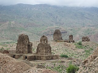
Hinduism is a minority religion in the Khyber Pakhtunkhwa province followed by 0.02% of the population of the province as per 2017 Census.

