The Tebrau River (Malay : Sungai Tebrau) is a river in Johor, Malaysia. [1]
The Tebrau River (Malay : Sungai Tebrau) is a river in Johor, Malaysia. [1]

The Johor Strait is an international strait in Southeast Asia, between Singapore and Peninsular Malaysia.

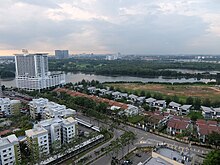
The Johor Bahru District is a district located in the southern part of Johor, Malaysia. The heavily suburban/suburbanizing district covers an area of 1,063.97 km2 (410.80 sq mi) and has a population of 1.71 million. The district capital is Johor Bahru City and the administrative capital is Iskandar Puteri City. The district borders Pontian District on the west, Kota Tinggi District on the east, Kulai District on the north and Straits of Johor to the south. The urban centres are divided into the cities of Johor Bahru, Iskandar Puteri and Pasir Gudang.
Johor Bahru–Kota Tinggi Highway (Malay: Lebuhraya Johor Bahru–Kota Tinggi), Federal Route 3, also known as Tebrau Highway (Jalan Tebrau) and Jalan Kota Tinggi is a highway that encompasses Federal Route 3 in Johor Bahru, Malaysia. Part of Asian Highway Route AH18, the highway stretches from its southern end at Jalan Wong Ah Fook and Jalan Tun Abdul Razak in the metropolitan area of Johor Bahru to the northern end at the underpass flyover with North–South Expressway Southern Route and Johor Bahru Eastern Dispersal Link Expressway around Pandan. The stretch of Tebrau Highway after this continues as Jalan Pandan and Jalan Kota Tinggi respectively, beyond Pandan. The highway became the backbone of the Johor Bahru road system linking Pandan to the city centre, and to the Johor–Singapore Causeway, before being surpassed by the Johor Bahru Eastern Dispersal Link Expressway in 2012.

The Bernam River is a river located between the Malaysian states of Perak and Selangor, demarcating the border of the two states. The river also separates the respective districts of Muallim and Bagan Datuk on the north and Hulu Selangor and Sabak Bernam in the south.

The Rejimen Askar Wataniah is the military reserve force of the Malaysian Army.

The Selangor River is a major river in Selangor, Malaysia. It runs from Kuala Kubu Bharu in the east and empties into the Straits of Malacca at Kuala Selangor in the west.

The Kerian River, alternately Krian, is a river in the northern part of the Malaysian state of Perak. The river originates from the Bintang Range. It flows westerly and discharges into the Strait of Malacca. The main tributaries are the Selama River, Ijok River, Samagagah River and Ulu Mengkuang River.

The Kesang River is the border river between Johor and Malacca states of Malaysia, together with the Chohong River. It supplies more than 54 million litres of water daily to the residents.
The Skudai River is located in Johor, Malaysia. Its main tributary originated from a small creek within an oil palm plantation in Kg. Sedenak, Kulai, then flowing south-ward towards the Johor Bahru city. Its river mouth is located in Danga Bay, Tampoi discharging its water to the narrow Tebrau Straits. The length of its main tributary is about 43 km, whilst the overall tributaries length is approximately 308 km. The Skudai River Basin (SRB) comprises 270 km2 of land, divided into 22 sub-catchments. It is within the jurisdiction area of Kulai Municipal Council (MPKu), Iskandar Puteri CIty Council (MBIP), and Johor Bahru CIty Council (MBJB). Among its main tributaries and sub-catchments are the Danga River (15.3 km), Melana River (15.9 km), Senai River (10.4 km), Anak Sungai Melana (5.8 km), UTM River (5.3 km), Kempas River (4.8 km), and Sri Sengkang River (8.4 km). This network of streams flows through several towns, huge residential establishments and several industrial parks, making them susceptible to pollution. The Danga River and Kempas River have been identified as the most polluted tributaries within SRB.

The Pulai River is a river in Johor, Malaysia. It runs from Mount Pulai in Kulai District until Tanjung Pelepas, draining into the Tebrau Straits. At its mouth lies the single largest seagrass bed in Malaysia, which extends all the way to Pulau Merambong. Sungai Pulai is also a mangrove forest reserve. The site is being studied to help manage the vast mangrove ecosystem, with assistance from University of Technology Malaysia and the National University of Malaysia, in line with the Integrated Management Plan for the sustainable use of mangroves in Johor.

The Batu Pahat River is a river originating from Sungai Simpang Kiri and Sungai Simpang Kanan near Tongkang Pechah, and flows through Batu Pahat and until it reaches the mouth of the river in Pantai Minyak Beku, a seaside village lying on the west coast of Johor, Malaysia.

The Perlis River is a river in Perlis, Malaysia.

The Damansara River is a river in Selangor state, Malaysia. It runs from Sungai Buloh until Shah Alam.
Bintangor River is a river in Sarawak, Malaysia. It is a tributary to the Rajang River. The river has previously had issues with pollution, but in recent years initiatives have been undertaken to improve the situation.
The Igan River is a river in Sarawak, Malaysia. It joins the Sungai Rajang in Sibu. The 95 km long river is still used as the primary route for travel to a number of rural districts in Sarawak.

The Kemena River is a river in Bintulu Division, Sarawak state, Malaysia. It flows past Sebauh and Bintulu, and is used for transporting timber and oil from the interior.
Majidee Malay Village is a Malay village located in the city of Johor Bahru, Johor, Malaysia.

Floods in Malaysia are one of the most regular natural disasters affecting the country, which occurs nearly every year especially during the monsoon season. The coasts of peninsular Malaysia are the most prone to flooding especially during the northeast monsoon season from October to March.

Sungai Ara is a residential neighbourhood within the city of George Town in the Malaysian state of Penang. Located 11.9 km (7.4 mi) south of the city centre, it lies between Relau, Bayan Baru and Bayan Lepas.
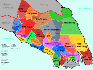
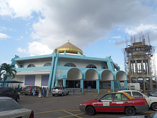
Tebrau is a federal constituency in Johor Bahru District, Kulai District and Kota Tinggi District, Johor, Malaysia, that has been represented in the Dewan Rakyat since 1986.
| | This Johor location article is a stub. You can help Wikipedia by expanding it. |
| | This article related to a river in Malaysia is a stub. You can help Wikipedia by expanding it. |